


Summary
Ville (French pronunciation: [vil] ⓘ) is a commune in the Oise department in the region of Hauts-de-France in northern France. The village is divided into a northern part and a southern part by the river Divette.
Ville | |
|---|---|
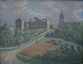 The château in disrepair painted by Général Léon Grégoire in 1927 | |
Location of Ville .mw-parser-output .locmap .od{position:absolute}.mw-parser-output .locmap .id{position:absolute;line-height:0}.mw-parser-output .locmap .l0{font-size:0;position:absolute}.mw-parser-output .locmap .pv{line-height:110%;position:absolute;text-align:center}.mw-parser-output .locmap .pl{line-height:110%;position:absolute;top:-0.75em;text-align:right}.mw-parser-output .locmap .pr{line-height:110%;position:absolute;top:-0.75em;text-align:left}.mw-parser-output .locmap .pv>div{display:inline;padding:1px}.mw-parser-output .locmap .pl>div{display:inline;padding:1px;float:right}.mw-parser-output .locmap .pr>div{display:inline;padding:1px;float:left}html.skin-theme-clientpref-night .mw-parser-output .od,html.skin-theme-clientpref-night .mw-parser-output .od .pv>div,html.skin-theme-clientpref-night .mw-parser-output .od .pl>div,html.skin-theme-clientpref-night .mw-parser-output .od .pr>div{background:#000;color:#fff}html.skin-theme-clientpref-night .mw-parser-output .locmap{filter:grayscale(0.6)}@media(prefers-color-scheme:dark){html.skin-theme-clientpref-os .mw-parser-output .locmap{filter:grayscale(0.6)}html.skin-theme-clientpref-os .mw-parser-output .od,html.skin-theme-clientpref-os .mw-parser-output .od .pv>div,html.skin-theme-clientpref-os .mw-parser-output .od .pl>div,html.skin-theme-clientpref-os .mw-parser-output .od .pr>div{background:#000;color:#fff}}  Ville  Ville | |
| Coordinates: 49°33′18″N 2°56′26″E / 49.555°N 2.9406°E | |
| Country | France |
| Region | Hauts-de-France |
| Department | Oise |
| Arrondissement | Senlis |
| Canton | Noyon |
| Intercommunality | Pays Noyonnais |
| Government | |
| • Mayor (2020–2026) | Philippe Barbillon[1] |
| Area 1 | 6.04 km2 (2.33 sq mi) |
| Population (2021)[2] | 750 |
| • Density | 120/km2 (320/sq mi) |
| Time zone | UTC+01:00 (CET) |
| • Summer (DST) | UTC+02:00 (CEST) |
| INSEE/Postal code | 60676 /60400 |
| Elevation | 41–164 m (135–538 ft) |
| 1 French Land Register data, which excludes lakes, ponds, glaciers > 1 km2 (0.386 sq mi or 247 acres) and river estuaries. | |
Demographics edit
The population of the town is relatively young. The rate of persons above the age of 60 years (21.0%) is lower than the national rate (26.4%) and the department rate (23.4%).[3]
| Year | Pop. | ±% p.a. |
|---|---|---|
| 1968 | 495 | — |
| 1975 | 555 | +1.65% |
| 1982 | 552 | −0.08% |
| 1990 | 613 | +1.32% |
| 1999 | 675 | +1.08% |
| 2009 | 780 | +1.46% |
| 2014 | 768 | −0.31% |
| 2020 | 755 | −0.28% |
| Source: INSEE[3] | ||
The château edit
The first castle stood at a place later known as Le Vieux Château (The Old Castle) near the junction of Rue du Château and Rue de l'Archerie. By the early 19th century the castle was in ruins and in 1840 it was replaced by a new château comprising a main building and two symmetrical wings situated just to the north east of the village church. This building was partially destroyed during the First World War and rebuilt on the old plans in the late 1920s.
See also edit
References edit
- ^ "Répertoire national des élus: les maires" (in French). data.gouv.fr, Plateforme ouverte des données publiques françaises. 13 September 2022.
- ^ "Populations légales 2021". The National Institute of Statistics and Economic Studies. 28 December 2023.
- ^ a b Évolution et structure de la population en 2020, INSEE