
KNOWPIA
WELCOME TO KNOWPIA

Villebarou 
Summary
Villebarou (pronounced [vilˈbaʁu]) is a commune in the Loir-et-Cher department, Centre-Val de Loire, France. It is located 3.8 km (2.4 mi) from Blois.
Villebarou | |
|---|---|
Commune | |
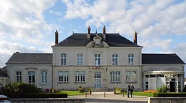 Town hall | |
Location of Villebarou .mw-parser-output .locmap .od{position:absolute}.mw-parser-output .locmap .id{position:absolute;line-height:0}.mw-parser-output .locmap .l0{font-size:0;position:absolute}.mw-parser-output .locmap .pv{line-height:110%;position:absolute;text-align:center}.mw-parser-output .locmap .pl{line-height:110%;position:absolute;top:-0.75em;text-align:right}.mw-parser-output .locmap .pr{line-height:110%;position:absolute;top:-0.75em;text-align:left}.mw-parser-output .locmap .pv>div{display:inline;padding:1px}.mw-parser-output .locmap .pl>div{display:inline;padding:1px;float:right}.mw-parser-output .locmap .pr>div{display:inline;padding:1px;float:left}html.skin-theme-clientpref-night .mw-parser-output .od,html.skin-theme-clientpref-night .mw-parser-output .od .pv>div,html.skin-theme-clientpref-night .mw-parser-output .od .pl>div,html.skin-theme-clientpref-night .mw-parser-output .od .pr>div{background:#000;color:#fff}html.skin-theme-clientpref-night .mw-parser-output .locmap{filter:grayscale(0.6)}@media(prefers-color-scheme:dark){html.skin-theme-clientpref-os .mw-parser-output .locmap{filter:grayscale(0.6)}html.skin-theme-clientpref-os .mw-parser-output .od,html.skin-theme-clientpref-os .mw-parser-output .od .pv>div,html.skin-theme-clientpref-os .mw-parser-output .od .pl>div,html.skin-theme-clientpref-os .mw-parser-output .od .pr>div{background:#000;color:#fff}}  Villebarou  Villebarou | |
| Coordinates: 47°37′24″N 1°19′27″E / 47.6233°N 1.3242°E | |
| Country | France |
| Region | Centre-Val de Loire |
| Department | Loir-et-Cher |
| Arrondissement | Blois |
| Canton | Blois-2 |
| Intercommunality | CA Blois Agglopolys |
| Government | |
| • Mayor (2020–2026) | Philippe Masson[1] |
| Area 1 | 9.11 km2 (3.52 sq mi) |
| Population (2021)[2] | 2,519 |
| • Density | 280/km2 (720/sq mi) |
| Time zone | UTC+01:00 (CET) |
| • Summer (DST) | UTC+02:00 (CEST) |
| INSEE/Postal code | 41276 /41000 |
| Elevation | 108–121 m (354–397 ft) (avg. 120 m or 390 ft) |
| 1 French Land Register data, which excludes lakes, ponds, glaciers > 1 km2 (0.386 sq mi or 247 acres) and river estuaries. | |
History edit
Archaeological assessment suggests ancient settlement near the present-day Vendôme Route, with ceramics dating from the 1st and 2nd centuries.[3]
Population edit
|
| ||||||||||||||||||||||||||||||||||||||||||||||||||||||
| Source: EHESS[4] and INSEE (1968-2017)[5] | |||||||||||||||||||||||||||||||||||||||||||||||||||||||
See also edit
References edit
- ^ "Répertoire national des élus: les maires" (in French). data.gouv.fr, Plateforme ouverte des données publiques françaises. 13 September 2022.
- ^ "Populations légales 2021". The National Institute of Statistics and Economic Studies. 28 December 2023.
- ^ Guiot, T (2015). "Villebarou - Les Mardeaux". Archéologie de la France - Informations. doi:10.4000/adlfi.14258.
- ^ Des villages de Cassini aux communes d'aujourd'hui: Commune data sheet Villebarou, EHESS (in French).
- ^ Population en historique depuis 1968, INSEE
Wikimedia Commons has media related to Villebarou (Loir-et-Cher).