
KNOWPIA
WELCOME TO KNOWPIA

Villers-Saint-Frambourg-Ognon 
Summary
Villers-Saint-Frambourg-Ognon (French pronunciation: [vilɛʁ sɛ̃ fʁɑ̃buʁ ɔɲɔ̃]) is a commune in the northern French department of Oise. It was established on 1 January 2019 by merger of the former communes of Villers-Saint-Frambourg (the seat) and Ognon.[3]
Villers-Saint-Frambourg-Ognon | |
|---|---|
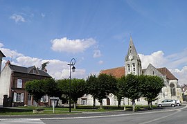 The main square in Villers-Saint-Frambourg | |
Location of Villers-Saint-Frambourg-Ognon .mw-parser-output .locmap .od{position:absolute}.mw-parser-output .locmap .id{position:absolute;line-height:0}.mw-parser-output .locmap .l0{font-size:0;position:absolute}.mw-parser-output .locmap .pv{line-height:110%;position:absolute;text-align:center}.mw-parser-output .locmap .pl{line-height:110%;position:absolute;top:-0.75em;text-align:right}.mw-parser-output .locmap .pr{line-height:110%;position:absolute;top:-0.75em;text-align:left}.mw-parser-output .locmap .pv>div{display:inline;padding:1px}.mw-parser-output .locmap .pl>div{display:inline;padding:1px;float:right}.mw-parser-output .locmap .pr>div{display:inline;padding:1px;float:left}html.skin-theme-clientpref-night .mw-parser-output .od,html.skin-theme-clientpref-night .mw-parser-output .od .pv>div,html.skin-theme-clientpref-night .mw-parser-output .od .pl>div,html.skin-theme-clientpref-night .mw-parser-output .od .pr>div{background:#000;color:#fff}html.skin-theme-clientpref-night .mw-parser-output .locmap{filter:grayscale(0.6)}@media(prefers-color-scheme:dark){html.skin-theme-clientpref-os .mw-parser-output .locmap{filter:grayscale(0.6)}html.skin-theme-clientpref-os .mw-parser-output .od,html.skin-theme-clientpref-os .mw-parser-output .od .pv>div,html.skin-theme-clientpref-os .mw-parser-output .od .pl>div,html.skin-theme-clientpref-os .mw-parser-output .od .pr>div{background:#000;color:#fff}}  Villers-Saint-Frambourg-Ognon  Villers-Saint-Frambourg-Ognon | |
| Coordinates: 49°15′21″N 2°38′24″E / 49.2558°N 2.64°E | |
| Country | France |
| Region | Hauts-de-France |
| Department | Oise |
| Arrondissement | Senlis |
| Canton | Pont-Sainte-Maxence |
| Intercommunality | Senlis Sud Oise |
| Government | |
| • Mayor (2020–2026) | Laurent Nocton[1] |
| Area 1 | 14.54 km2 (5.61 sq mi) |
| Population (2021)[2] | 719 |
| • Density | 49/km2 (130/sq mi) |
| Time zone | UTC+01:00 (CET) |
| • Summer (DST) | UTC+02:00 (CEST) |
| INSEE/Postal code | 60682 /60810 |
| Elevation | 63–215 m (207–705 ft) |
| 1 French Land Register data, which excludes lakes, ponds, glaciers > 1 km2 (0.386 sq mi or 247 acres) and river estuaries. | |
See also edit
References edit
- ^ "Répertoire national des élus: les maires" (in French). data.gouv.fr, Plateforme ouverte des données publiques françaises. 13 September 2022.
- ^ "Populations légales 2021". The National Institute of Statistics and Economic Studies. 28 December 2023.
- ^ Arrêté préfectoral 28 September 2018, modified 14 December 2018 (in French)
Wikimedia Commons has media related to Villers-Saint-Frambourg-Ognon.