


Summary
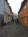
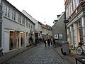
Volden (Lit. The Rampart) is a 180 meters long street in Aarhus, Denmark, situated in the historic Latin Quarter neighborhood. Volden runs from south to north from Store Torv to Graven and intersects Rosensgade roughly in the middle. Volden was created some time before year 1500 on and in the westernmost rampart used to defend the early Viking settlement.[1] It is one of the oldest streets in the city and used to mark the western city limits. Volden is fairly narrow and is a pedestrianized street with cars forbidden access.[2]
 Volden | |
| Length | 180 m (590 ft) |
|---|---|
| Location | Latin Quarter, Aarhus, Denmark |
| Postal code | 8000 |
| Coordinates | 56°09′29.9″N 10°12′31.4″E / 56.158306°N 10.208722°E |
History edit
The early Viking settlement was defended by moats and ramparts to the north, west and south.[3] During the Middle Ages the city grew beyond the boundaries marked by these defenses and at the same time advents in warfare had made such structures less useful for defense. Some time before 1500 the ramparts and moats were dismantled and the street Volden was established on the former westernmost rampart.[4] The street Badstuegade runs parallel to Volden to the west and archaeological excavations have shown evidence of a former moat and the foundations of an old city gate by the building Borgporten (Lit. Castle Gate). It is believed the surplus earth from the rampart was used to fill in the moat Badstuegade was established on.[5][6]
Until 1867 the southern section of Volden, nearest Store Torv, was called Pustervig which is a common name known from other Danish cities. The word "puz" means water-filled hole or mud-pit so some theories speculate that the area may have been swampy. Another theory is that it is related to blacksmiths which at the time were called kulpustere (coal-blowers) for their use of bellows.[7] Additionally, blacksmiths in medieval towns tended to be located at the outskirts or by open areas to protect thatched housing from fire and embers. The building on the corner of Volden and Rosensgade was called smedegården (smith's house) until 1562 and was owned by the blacksmiths' guild. The name pustervig can then best be translated as smedegade (Smith street) and it was likely where blacksmiths plied their trade in the Middle Ages.[8]
Gallery edit


References edit
- ^ Emanuel 1960, p. 51, line 5: "Som navnet Volden antyder, er denne gade anlagt ved ellcr på den udjævnede bybefæstningsvold og må således formodontlig stamme fra slutningen af middelalderen."
- ^ "Volden" (in Danish). Aarhus City Archives. Archived from the original on 5 January 2017. Retrieved 4 January 2017.
- ^ Emanuel 1960, p. 51, line 10: "At der har været flere grave og volde fremgår af, at en jordskyldsbog fra I562 nævner mester >Thomas Ribers grund på Nørregrave og Volden<, Iigesom der omtales en >urtehave på Nørrevold<. Der har altså også været en Søndergrave og en Søndervold<."
- ^ Weinreich 2007, p. 55, line 5-8: ...i 1562 omtales mester Ribers grund på Nprregrav og Volden."
- ^ Emanuel 1960, p. 51, line 12: "Volden er formodentlig udjævnet og brugt til at opfylde graveq med."
- ^ "Graven" (in Danish). Aarhus City Archives. Archived from the original on 20 December 2016. Retrieved 9 December 2016.
- ^ Emanuel 1960, p. 46, line 13: "I øvrigt hed den søndre del af gaden Volden nærmest Store Torv ligc indtil 1867 Pustervig, et gadenavn som også kendes fra andre byer."
- ^ Emanuel 1960, p. 46, line 15: "Det er da sandsynligt, at smedene i det gamle Århus har boet ved Volden, og vi ved også, at gården på hjørnet af Rosensgade og Volden i 1562 kaldtes smedegården og var smedelavets ejendom. Pustervig kan altså bedst oversættes til Smedegade."
- Publications
- Sejr, Emanuel (1960). Gamle Århusgader – Første samling. Århus Byhistoriske Udvalg. ISBN 87-504-0353-2.