


Summary
Voltri is a quartiere of the Italian city of Genoa, located 17 kilometres (10.6 mi) west of the city centre. It was formerly an independent comune.
Voltri
Utri | |
|---|---|
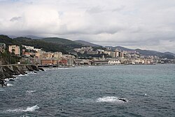 View of Voltri from the Mulino di Crevari | |
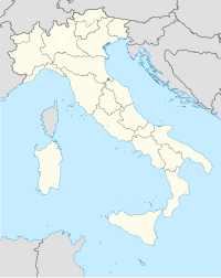 Voltri Location in Italy | |
| Coordinates: 44°25′42″N 8°45′8″E / 44.42833°N 8.75222°E | |
| Country | Italy |
| Region | Liguria |
| Province | Province of Genoa |
| Comune | Genoa |
| Population | |
| • Total | 12,402 |
| Area code | 010 |


In 2015, Voltri and the nearby hamlets included in Genoa's VII Municipio (Crevari, Acquasanta, Vesima, Fabbriche) had a total population of 12,402. Voltri is one of the 3 former municipalities (the other ones are Pra' and Pegli) being part of the Genoa's city VII Municipio.
History edit
The area of Voltri was inhabited since prehistoric times, and was a center of the Ligures tribe of the Veituri, from which it probably took its name. In the Middle Ages it was a hamlet part of the Republic of Genoa, its main activity being the production of paper.
In 1796 Voltri was the site of a battle between the French troops of Napoléon Bonaparte and of the Austrian Empire allied with the Kingdom of Sardinia-Piedmont. After the fall of the First French Empire, it became an autonomous commune in the Sardinian territories, a status it kept until 1926, when the Fascist government united it to Genoa.
Main sights edit
- Sanctuary of Madonna delle Grazie, a Capuchine monastery
- Sanctuary of Nostra Signora dell'Acquasanta (built in 1683-1718), a Baroque sanctuary housing works by Lazzaro Tavarone, Anton Maria Maragliano, Antonio Brilla and Domenico Fiasella.
- Church of Sant'Ambrogio
- Villa Brignole Sale Duchessa di Galliera
Transportation edit
Voltri is served by a station on the Genoa-Ventimiglia railroad. Another railway station is present in Acquasanta along the Genoa-Acqui Terme railroad, 6 km far from Voltri. It is also crossed by the SS1 Via Aurelia national road and by the A10 and the A26 motorways. The motorway exit is located in Pra, 1 km from Voltri. From Voltri it is possible to overcome the Appennino ligure by traveling via the passo del Turchino.
See also edit
44°25′42″N 8°45′8″E / 44.42833°N 8.75222°E