


Summary
The WSR-1 or Weather Surveillance Radar-1 was one of the first weather radars and the first used by a civilian organization in the US.[2] The WSR-1 series was a modified version of the AN/APS-2F radar, which the Weather Bureau (now the National Weather Service) acquired from the Navy. The WSR-1A, WSR-3, and WSR-4 were also variants of this radar.[1] The first WSR-1 in the USA was at Washington National Airport in Washington, D.C. in 1947,[1] and the last WSR-3 was retired by 1978.[3]
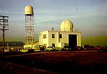 The upper air and radar (WSR-1) site, on the left, at the North Omaha Airport from 1954 to 1974. | |
| Country of origin | United States |
|---|---|
| Introduced | 1946 |
| No. built | 82 |
| Type | Weather radar |
| Frequency | 3.3 GHz (S band) |
| PRF | 325 and 650 Hz |
| Beamwidth | 3.5° |
| Pulsewidth | 1 and 2μs excepted 1 and 4 μs on WSR-4 |
| Range | more than 100 kilometres (62 mi) |
| Diameter | 2 m |
| Azimuth | 0 to 360º |
| Elevation | -2 to 50º |
| Power | 50 kW |
History edit
In 1946, the US Weather Bureau (ancestor of the National Weather Service) retrieved 25 AN/APS-2F aeronautical radars from the US Navy. The radars have been modified and adapted to meteorology and then delivered at the rate of five per year. The modifications were conducted by the weather service and the modified radars took the successive names of WSR-1, WSR-1A, WSR-3 and WSR-4, depending on the gradual improvement of hardware.[1] The first WSR-1 was put into service at the Washington, DC, national airport on March 12, 1947. The second began service on June 1, 1947 in Wichita, Kansas, in the heart of the Tornado Alley.[1] In August of the same year, the WSR-1 installed at Norfolk, Nebraska proved its usefulness and cost savings by alerting the Elkhorn Valley power system of the approach of thunderstorms.[1]
Three particularly severe weather events occurred during the spring of 1953 and led to the establishment of the Texas Tornado Warning Network. Major cities in Texas have been asked to fund the operation (both the private and public sectors) of modifying and implementing the WSR-1, WSR-1A, WSR-3 and WSR-4. The Weather Bureau agreed to operate these radars and maintain them in order to alert the public in case of danger, as soon as a visual confirmation was obtained. The establishment of the network became effective during a kick-off meeting on June 24, 1953.[1] It took nearly six years for the network to be fully operational; 17 radars have been modified and installed thanks to the joint efforts of local authorities, the state, federal agencies and a university.[1]
The APS-2F modified by Texas A & M University, although not actually part of the tornado surveillance network, was at least once used for warning purposes on April 5, 1956.[1] After 1956 the modification of the APS-2F radars in their WSR-1, WSR-1A, WSR-3 and WSR-4 versions was assigned to the Weather Office headquarters which had to move some antennas that had originally been installed to locations where it was difficult to ensure the maintenance.[1]
In April 1975, at the peak of the program, 82 WSR-1, WSR-1A, WSR-3 and WSR-4 were in service.[1] Some were replaced by WSR-57s, but most remained in service until they were replaced by WSR-74s during a period from 1976 to 1980.[1] No more remains in service today.
Characteristics edit

The WSR-1 to 4 series, the first operational weather radar in the United States, used the AN/APS-2F electronics, including a superheterodyne receiver, but with a larger antenna. As time progressed and experience with the original design increased, the Weather Bureau felt confident enough to upgrade the WSR-1 to WSR-1A, eventually finalizing on the WSR-3 and WSR-4 model. The WSR-4 upgrades included the removal of the original aircraft-oriented antenna in favor of a larger antenna, and the addition of a power converter such that it would now have the ability to function on conventional power.[1]
The main difference between the versions was their display and the control of the probed atmospheric volume. The diameter of the dish was nearly 2 meters by the WSR-4. The wavelength used was about 10 cm which corresponds to a frequency of 3 GHz. This frequency is in the S band which is still used by the current US weather radar network. Thanks to the radars operative frequency, the attenuation due to the rain was almost zero,[4] but the detection of a light rain or snow was delicate because of the weakness of the signal emitted by the radar (50 kW).[1]

The WSR-1 used a panoramic display (PPI) placing weather echoes in azimuth/distance coordinates on a circular screen whose center represented the position of the radar, and also a linear oscilloscope (A-Scope) showing the intensity of the echoes according to their distance from the radar.[1] Everything was mounted on a rack. The WSR-3 and WSR-4 used A-Scope displays and height/distance displays (RHI) which allows a vertical sectional view in a chosen direction. They were mounted next to each other on a console. The WSR-1A used the same displays but stacked vertically. From a technical point of view, the WSR-4 had a traveling-wave tube that improved the sensitivity compared to the WSR-3.[1]
Radar Sites edit

The 82 radar sites of WSR1, 1A, 3 and 4 are listed below
| Location | Commissioned | Decommissioned | Replaced by |
|---|---|---|---|
| Baton Rouge, LA | August 16, 1955 | 1973? | |
| Burrwood, LA | 1956 | 1960 | WSR-4 |
| Fort Worth, TX | April 21, 1954 | April 1961 | WSR-57 |
| Hartford, CT | 1955 | 1959 | WSR-3 |
| Dodge City, KS | June 13, 1954 | July 25, 1963 | WSR-3 |
| Lubbock, TX | 1954 | August 1972 | WSR-74C |
| Norfolk, NE | July 27, 1947 | 1976 | WSR-74C |
| North Omaha, NE | 1955 | 1977 | WSR-74C |
| Oklahoma City, OK | March 1, 1955 | 1960 | WSR-57 |
| Philadelphia, PA | November 20, 1959 | ? | |
| Pittsburgh, PA | 1952? | October 4, 1963 | |
| Port Arthur, TX | July 15, 1955 | ? | |
| St. Louis, MO | June 1955 | 1960 | WSR-57 |
| Shreveport, LA | November 1955 | 1976 | WSR-74C |
| Sioux Falls, SD | 1956 | 1976? | WSR-74C |
| Springfield, MO | June 28, 1957 | ? | |
| Tampa, FL | 1956 | 1960 | WSR-57 |
| Topeka, KS | 1953 | 1957 | WSR-3 |
| Tulsa, OK | May 4, 1956 | 1976 | WSR-74C |
| Waco, TX | April 28, 1955 | 1976 | WSR-74C |
| Washington, DC | March 12, 1947 | ? | |
| Wichita, KS | June 1, 1947 | June 5, 1956 | WSR-3 |
| Wichita Falls, TX | April 25, 1956 (Replaced a military APS-2F radar) |
1977 | WSR-74C |
| Worcester, MA | March 16, 1956 | 1976 | WSR-74C |
| Location | Commissioned | Decommissioned | Replaced by |
|---|---|---|---|
| Abilene, TX | 25 March 1972 | 27 August 1977 | WSR-74C |
| Albany, NY | 12 November 1958 | 27 July 1977 | WSR-74C |
| Astoria, OR | 1 June 1959 | 1 November 1967 | |
| Binghamton, NY | 15 June 1959 | 8 March 1978 | WSR-74S |
| Chicago/Midway, IL | 19 April 1958 | January 1963 | WSR-57 |
| Cleveland, OH | 13 May 1957 | WSR-74C | |
| Columbia, MO | August 1957 | November 1977 | WSR-74C |
| Columbus, OH | 12 February 1959 | 19 January 1977 | |
| Détroit, MI | 1 May 1957 | 12 September 1962 | WSR-57 |
| Dodge City, KS | 25 July 1963 | 25 July 1972 | |
| Eureka, CA | 1957 | June 1972 | Given to California State University in Humboldt |
| Flint, MI | 15 November 1957 | 15 January 1978 | |
| Fort Smith, AR | 30 August 1960 | 29 December 1975 | WSR-74C |
| Fort Wayne, IN | 1957 | 12 March 1976 | WSR-74C |
| Hartford, CT | 29 April 1959 | April 1977 | WSR-74C |
| Hunstville, AL | October 1958 | 1977 | WSR-74C |
| Location | Commissioned | Decommissioned | Replaced by |
|---|---|---|---|
| Indianapolis, IN | October 1959 | September 1977 | WSR-74C |
| Jackson, MS | 1959 | 1969 | WSR-57 |
| Little Rock, AR | 19 December en remplacement d'un AN/APS-2E militaire | 19 April 1962 | WSR-57 |
| Macon, GA | 21 April 1958 | 18 April 1977 | WSR-74C |
| Madison, WI | 29 March 1958 | 15 May 1979 | WSR-74C |
| Memphis, TN | 1957 | ? | |
| Meridian, MS | 16 August 1959 | 2 November 1976 | WSR-74C |
| Miami, FL | Durant la Seconde Guerre mondiale | ? | |
| Montgomery, AL | October 1958 | 1971 | WSR-74C in 1977 |
| Muskegon, MI | 9 May 1957 | 25 March 1976 | WSR-74C |
| Nashville, TN | 2 April 1957 | 31 October 1970 | WSR-57 |
| Richmond, VA | 7 July 1958 | October 1959 | |
| Rochester, MN | September 1960 | April 1976 | WSR-74C |
| Scottbluff, MO | Summer 1969 | 1978 | |
| Tatoosh Island, WA | 1 October 1960 | January 1964 | |
| Topeka, KS | 1957 | 1976 | WSR-74C |
| Wichita, Kansas | 5 June 1956 | 22 June 1960 | WSR-57 |
References edit
- ^ a b c d e f g h i j k l m n o p Whiton, Roger C.; al. (19 February 1998). "History of Operational Use of Weather Radar by U.S. Weather Services. Part I: The Pre-NEXRAD Era". Weather and Forecasting. 13 (2). American Meteorological Society: 219–243. doi:10.1175/1520-0434(1998)013<0219:HOOUOW>2.0.CO;2.
- ^ S. G. Bigler; P. L. Hexter Jr.; F. E. Wells (November 1962). "The Radar Program of the U. S. Weather Bureau". Bulletin of the American Meteorological Society. 43 (11): 591–603. doi:10.1175/1520-0477-43.11.591. ISSN 0003-0007. Retrieved 2021-09-04.
- ^ a b c d Chris Geelhart (Central Office in Illinois) (9 March 2011). "Brief History of National Weather Service Offices Past and Present". National Weather Service. Retrieved 5 April 2018.
- ^ David Atlas; Banks, Harold C. (October 1951). "The interpretation of microwave reflections from rainfall". Journal of Meteorology. 8 (5): 271–282. doi:10.1175/1520-0469(1951)008<0271:TIOMRF>2.0.CO;2.