


Summary
Wabe-Schunter-Beberbach is a Stadtbezirk (borough) in the north-eastern and eastern part of Braunschweig, Germany. The district is named after the river Schunter and its tributaries Wabe and Beberbach.
Wabe-Schunter-Beberbach | |
|---|---|
 Riddagshausen | |
Location of Wabe-Schunter-Beberbach within Braunschweig  | |
 Wabe-Schunter-Beberbach  Wabe-Schunter-Beberbach | |
| Coordinates: 52°16′50″N 10°33′37″E / 52.28056°N 10.56028°E | |
| Country | Germany |
| State | Lower Saxony |
| District | urban district |
| City | Braunschweig |
| Government | |
| • Mayor | Gerhard Stülten (SPD) |
| Area | |
| • Total | 30.568 km2 (11.802 sq mi) |
| Population (2020-12-31)[1] | |
| • Total | 20,204 |
| • Density | 660/km2 (1,700/sq mi) |
| Time zone | UTC+01:00 (CET) |
| • Summer (DST) | UTC+02:00 (CEST) |
| Postal codes | 38104-38110 |
| Dialling codes | 0531 |
| Vehicle registration | BS |
The Stadtbezirk comprises the quarters Bevenrode, Bienrode, Gliesmarode, Riddagshausen, Querum, and Waggum.
History edit
The district was formed in 2011 out of the former districts of Wabe-Schunter and Bienrode-Waggum-Bevenrode.[2][3] Both districts consisted of villages that were incorporated into Braunschweig during the 20th century, in 1934 (Gliesmarode, Querum, and Riddagshausen) and in 1974 (Bevenrode, Bienrode, and Waggum).
Main sights edit
- Riddagshausen Abbey (German: Kloster Riddagshausen), a former Cistercian monastery, with the surrounding nature reserve and arboretum, as well as the village of Riddagshausen with several old farm houses.[4] The nature reserve Riddagshäuser Teiche is designated as Important Bird Area[5] and Special Protection Area.[6]
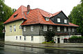
- The inn Grüner Jäger ("Green Huntsman") in Riddagshausen, built in the mid-18th century.
- The 12th century Church of the Holy Trinity (German: Zur Heiligen Dreifaltigkeit) in Bienrode.[7]
- The 12th century Church St. Peter and Paul in Bevenrode.
- The Gliesmaroder Turm, formerly a tower in the medieval fortifications of Braunschweig which was torn down in the 18th century and replaced with an inn of the same name which still stands.[8]
-
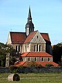 Riddagshausen Abbey
 -
 Riddagshausen nature reserve
 -
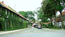
 Farm house in Riddagshausen
 -
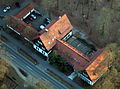 Grüner Jäger
 -
 Church of the Holy Trinity
 -
 Bevenrode with St. Peter and Paul
 -
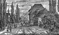 Gliesmaroder Turm in the 19th century
 -
 Gliesmaroder Turm in 2011


Politics edit
The district mayor Gerhard Stülten is a member of the Social Democratic Party of Germany.[9]
Transport edit
Train edit
Braunschweig-Gliesmarode station is located on the Brunswick–Uelzen railway line, which connects the district with Braunschweig Central Station and several towns in the Lüneburg Heath.
| Line | Route | Frequency | |
|---|---|---|---|
| RB | Braunschweig – Gifhorn – Wittingen – Uelzen | Every two hours | |
Air edit
The Braunschweig Airport (BWE / EDVE) is located near Waggum at 52°19′N 10°33′E / 52.317°N 10.550°E, elev. 295 ft (90 m)
Coats of arms edit
-
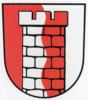
 Coat of arms of Bevenrode
 -
 Coat of arms of Bienrode
 -
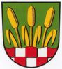
 Coat of arms of Gliesmarode
 -
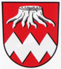
 Coat of arms of Querum
 -
 Coat of arms of Riddagshausen
 -
 Coat of arms of Waggum


References edit
- ^ "Einwohnerzahlen nach Stadtbezirken". Stadt Braunschweig. Retrieved 21 September 2021.
- ^ Boroughs of Braunschweig in 2010 (in German). Retrieved on October 4, 2012.
- ^ Boroughs of Braunschweig in 2011 (in German). Retrieved on October 4, 2012.
- ^ Die Geschichte des Ortes Riddagshausen (in German). Retrieved on October 4, 2012.
- ^ BirdLife Data Zone. Retrieved on November 4, 2012.
- ^ EUNIS Site factsheet. Retrieved on November 4, 2012.
- ^ History of the church (in German). Retrieved on October 4, 2012.
- ^ Gliesmaroder Turm (in German). Retrieved on October 4, 2012.
- ^ Stadtbezirksrat 112 Wabe-Schunter-Beberbach (in German). Retrieved on October 4, 2012.