


Summary
Waddington is a small village, 2 miles (3 km) north-west of Clitheroe in the Ribble Valley, Lancashire, England. The population of the civil parish at the 2011 census was 1,028.[1] Before the 1974 county boundary changes, Waddington fell just within the Bowland Rural District of the West Riding of Yorkshire. It covers approximately 2000 acres of the Forest of Bowland.
| Waddington | |
|---|---|
 Waddington Almshouses | |
 Waddington Shown within Ribble Valley  Waddington Location within Lancashire | |
| Population | 1,028 (2011) |
| OS grid reference | SD725435 |
| Civil parish |
|
| District | |
| Shire county | |
| Region | |
| Country | England |
| Sovereign state | United Kingdom |
| Post town | CLITHEROE |
| Postcode district | BB7 |
| Dialling code | 01200 |
| Police | Lancashire |
| Fire | Lancashire |
| Ambulance | North West |
| UK Parliament | |
Amenities edit
It is home to both an Anglican church and a Methodist church, a social club with bowling green, a cafe, a post office, a playing field on which both cricket and football are played. Also, within the village there are three pubs, the Lower Buck Inn, the Higher Buck and the Waddington Arms. The village is a regular winner of the Lancashire Best Kept Village awards.
History edit
Waddington was a mesne manor of the ancient Lordship of Bowland which comprised a Royal Forest and a Liberty of ten manors. These spanned eight townships and four parishes, covering an area of almost 300 square miles (780 km2) on the historic borders of Lancashire and Yorkshire.[2] The manors within the Liberty were Slaidburn (Newton-in-Bowland, West Bradford, Grindleton), Knowlmere, Waddington, Easington, Bashall Eaves, Mitton, Withgill (Crook), Leagram, Hammerton and Dunnow (Battersby).[3]
The Tempests were lords of the manor of Waddington from at least the early thirteenth century. The family is credited with endowing the parish church at Waddington.[4] One of their number, Sir Nicholas Tempest, a Bowbearer of the Forest of Bowland, was hanged, drawn and quartered at Tyburn in 1537 for his part in the Pilgrimage of Grace.[5]
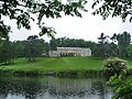
Following his defeat in the Battle of Hexham during the Wars of the Roses on 15 May 1464, King Henry VI was sheltered by Lancastrian supporters at houses across the north of England. Following stays at Muncaster Castle on the Cumbrian coast and at nearby Bolton Hall, he went into hiding at Waddington Hall,[6] the home of Sir Richard Tempest. He was betrayed by "a black monk of Addington" and on 13 July 1465, a group of Yorkist men, including Sir Richard's brother John, entered the home to arrest him. Henry fled into nearby woods but was soon captured.[7][8][9]
Waddington almshouses were endowed by Robert Parker of Browsholme Hall in 1700. St Helen's Church, which was rebuilt in 1825, has monuments to the Parker family.[6]
Governance edit
Along with West Bradford, Grindleton and Sawley, the parish forms the Waddington and West Bradford ward of Ribble Valley Borough Council. [10][11] The ward had a population of 2,636 in 2001,[12] rising to 2,933 in 2011.[13] The ward elects two councillors, who currently are Paul Elms and Bridget Hilton, both of the Conservative Party.[14]
Media gallery edit
-

-
 The Lower Buck Inn
 -
 Waddington and West Bradford Primary School
 -
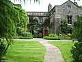 Waddington Old Hall
 -
 Waddington Methodist Church
 -


See also edit
References edit
- ^ UK Census (2011). "Local Area Report – Waddington Parish (1170215135)". Nomis. Office for National Statistics. Retrieved 24 February 2018.
- ^ "Lord of the Fells, Guardian of History" (PDF). Rural Life. November 2014.
- ^ Forest of Bowland official website
- ^ Frederick George Ackerley, A History of the Parish of Mitton in the West Riding of Yorkshire (Aberdeen University Press 1947)
- ^ RW Hoyle, The Pilgrimage of Grace and the Politics of the 1530s (Oxford University Press 2001)
- ^ a b "Waberthwaite - Waghen Pages 429-432 A Topographical Dictionary of England". British History Online. S Lewis, London 1848. Retrieved 18 November 2023.
- ^ Elizabeth Ashworth, The Capture of Henry VI
- ^ Jones, Dan (2 September 2014). The Hollow Crown: The Wars of the Roses and the Rise of the Tudors. Faber & Faber. ISBN 978-0-571-28809-0.
- ^ Weir, Alison (5 October 2011). The Wars of the Roses. Random House Publishing Group. ISBN 978-0-307-80685-7.
- ^ "Waddington and West Bradford". MARIO. Lancashire County Council. Retrieved 25 March 2016.
- ^ "Waddington and West Bradford". Ordnance Survey Linked Data Platform. Ordnance Survey. Retrieved 25 March 2016.
- ^ "Waddington and West Bradford ward population 2001". Neighbourhood Statistics. Office for National Statistics. Retrieved 25 March 2016.
- ^ UK Census (2011). "Local Area Report – Waddington and West Bradford 2011 Census Ward (1237324314)". Nomis. Office for National Statistics. Retrieved 24 February 2018.
- ^ "Councillors by Ward: Waddington and West Bradford". Ribble Valley Borough Council. Retrieved 23 March 2016.
External links edit
- Parish Council website
- Waddington Conservation Area Appraisal