


Summary
Waldeck-Frankenberg is a Kreis (district) in the north of Hesse, Germany. Neighbouring districts are Höxter, Kassel, Schwalm-Eder, Marburg-Biedenkopf, Siegen-Wittgenstein, Hochsauerland.
Waldeck-Frankenberg | |
|---|---|
 Flag 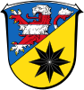 Coat of arms | |
 | |
| Country | Germany |
| State | Hesse |
| Adm. region | Kassel |
| Founded | 1974-01-01 |
| Capital | Korbach |
| Government | |
| • District admin. | Jürgen van der Horst |
| Area | |
| • Total | 1,848.58 km2 (713.74 sq mi) |
| Population (31 December 2022)[1] | |
| • Total | 159,154 |
| • Density | 86/km2 (220/sq mi) |
| Time zone | UTC+01:00 (CET) |
| • Summer (DST) | UTC+02:00 (CEST) |
| Vehicle registration | KB, FK, WA |
| Website | landkreis-waldeck-frankenberg.de |
History edit
The district was created in 1972 by merging the two districts of Frankenberg and Waldeck. Much of the area of the district had previously been part of the Free State of Waldeck until 1929, and its predecessor the Principality of Waldeck and Pyrmont before 1918.
Geography edit
The district is located in the mountains of the Sauerland, with the highest elevation in the district of 843 m (2,766 ft). With 1,848.58 km2 (713.74 sq mi), it's the largest district in Hessen.
Four artificial lakes created by dams are in the district, the biggest is the Edersee, which covers an area of 12 km2 (4.6 sq mi). The Eder is also the main river in the district; the Diemel in the north is a smaller river.
Mountains edit
Hills edit
Coat of arms edit
- Blason
- “Per bend sinister Azure a lion rampant issuant per fess Argent and Gules and Or a star with eight rays Sable.”
The coat of arms shows the lion of Hesse in chief. The eight-fold star in base is taken from the coat of arms of the counts and princes of Waldeck, and was also the coat of arms of the former district of Waldeck.

Towns and municipalities edit

- Towns
- Municipalities
References edit
- ^ "Bevölkerung in Hessen am 31.12.2022 nach Gemeinden" (XLS) (in German). Hessisches Statistisches Landesamt. June 2023.
External links edit
![]() Media related to Landkreis Waldeck-Frankenberg at Wikimedia Commons
Media related to Landkreis Waldeck-Frankenberg at Wikimedia Commons
- Official website (German)
51°16′09″N 8°51′24″E / 51.269298°N 8.856665°E