
KNOWPIA
WELCOME TO KNOWPIA

Waltenheim-sur-Zorn 
Summary
Waltenheim-sur-Zorn (German: Waltenheim an der Zorn) is a commune in the Bas-Rhin department in Grand Est in north-eastern France.[3]
Waltenheim-sur-Zorn | |
|---|---|
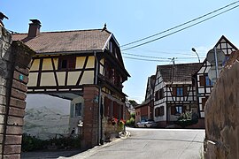 Waltenheim-sur-Zorn's center, featuring several half-timbered houses and a courtyard, common features of alsatian architecture | |
 Coat of arms | |
Location of Waltenheim-sur-Zorn .mw-parser-output .locmap .od{position:absolute}.mw-parser-output .locmap .id{position:absolute;line-height:0}.mw-parser-output .locmap .l0{font-size:0;position:absolute}.mw-parser-output .locmap .pv{line-height:110%;position:absolute;text-align:center}.mw-parser-output .locmap .pl{line-height:110%;position:absolute;top:-0.75em;text-align:right}.mw-parser-output .locmap .pr{line-height:110%;position:absolute;top:-0.75em;text-align:left}.mw-parser-output .locmap .pv>div{display:inline;padding:1px}.mw-parser-output .locmap .pl>div{display:inline;padding:1px;float:right}.mw-parser-output .locmap .pr>div{display:inline;padding:1px;float:left}html.skin-theme-clientpref-night .mw-parser-output .od,html.skin-theme-clientpref-night .mw-parser-output .od .pv>div,html.skin-theme-clientpref-night .mw-parser-output .od .pl>div,html.skin-theme-clientpref-night .mw-parser-output .od .pr>div{background:#000;color:#fff}html.skin-theme-clientpref-night .mw-parser-output .locmap{filter:grayscale(0.6)}@media(prefers-color-scheme:dark){html.skin-theme-clientpref-os .mw-parser-output .locmap{filter:grayscale(0.6)}html.skin-theme-clientpref-os .mw-parser-output .od,html.skin-theme-clientpref-os .mw-parser-output .od .pv>div,html.skin-theme-clientpref-os .mw-parser-output .od .pl>div,html.skin-theme-clientpref-os .mw-parser-output .od .pr>div{background:#000;color:#fff}}  Waltenheim-sur-Zorn  Waltenheim-sur-Zorn | |
| Coordinates: 48°44′50″N 7°37′48″E / 48.7472°N 7.63°E | |
| Country | France |
| Region | Grand Est |
| Department | Bas-Rhin |
| Arrondissement | Saverne |
| Canton | Bouxwiller |
| Intercommunality | Pays de la Zorn |
| Government | |
| • Mayor (2020–2026) | Jeannot Krebs[1] |
| Area 1 | 5.04 km2 (1.95 sq mi) |
| Population (2021)[2] | 664 |
| • Density | 130/km2 (340/sq mi) |
| Time zone | UTC+01:00 (CET) |
| • Summer (DST) | UTC+02:00 (CEST) |
| INSEE/Postal code | 67516 /67670 |
| Elevation | 147–258 m (482–846 ft) |
| 1 French Land Register data, which excludes lakes, ponds, glaciers > 1 km2 (0.386 sq mi or 247 acres) and river estuaries. | |
It lies on the road D332 next to the Marne-Rhine Canal.
Population edit
| Year | Pop. | ±% p.a. |
|---|---|---|
| 1968 | 522 | — |
| 1975 | 518 | −0.11% |
| 1982 | 551 | +0.89% |
| 1990 | 601 | +1.09% |
| 1999 | 641 | +0.72% |
| 2007 | 720 | +1.46% |
| 2012 | 669 | −1.46% |
| 2017 | 664 | −0.15% |
| Source: INSEE[4] | ||
See also edit
References edit
- ^ "Répertoire national des élus: les maires". data.gouv.fr, Plateforme ouverte des données publiques françaises (in French). 2 December 2020.
- ^ "Populations légales 2021". The National Institute of Statistics and Economic Studies. 28 December 2023.
- ^ INSEE commune file
- ^ Population en historique depuis 1968, INSEE
Wikimedia Commons has media related to Waltenheim-sur-Zorn.