
KNOWPIA
WELCOME TO KNOWPIA

Wambaix 
Summary
Wambaix (French pronunciation: [wɑ̃bɛ]) is a commune in the Nord department in northern France.[3] Wambaix station has rail connections to Douai, Cambrai and Saint-Quentin.
Wambaix | |
|---|---|
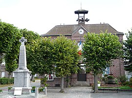 The town hall in Wambaix | |
 Coat of arms | |
Location of Wambaix .mw-parser-output .locmap .od{position:absolute}.mw-parser-output .locmap .id{position:absolute;line-height:0}.mw-parser-output .locmap .l0{font-size:0;position:absolute}.mw-parser-output .locmap .pv{line-height:110%;position:absolute;text-align:center}.mw-parser-output .locmap .pl{line-height:110%;position:absolute;top:-0.75em;text-align:right}.mw-parser-output .locmap .pr{line-height:110%;position:absolute;top:-0.75em;text-align:left}.mw-parser-output .locmap .pv>div{display:inline;padding:1px}.mw-parser-output .locmap .pl>div{display:inline;padding:1px;float:right}.mw-parser-output .locmap .pr>div{display:inline;padding:1px;float:left}html.skin-theme-clientpref-night .mw-parser-output .od,html.skin-theme-clientpref-night .mw-parser-output .od .pv>div,html.skin-theme-clientpref-night .mw-parser-output .od .pl>div,html.skin-theme-clientpref-night .mw-parser-output .od .pr>div{background:#000;color:#fff}html.skin-theme-clientpref-night .mw-parser-output .locmap{filter:grayscale(0.6)}@media(prefers-color-scheme:dark){html.skin-theme-clientpref-os .mw-parser-output .locmap{filter:grayscale(0.6)}html.skin-theme-clientpref-os .mw-parser-output .od,html.skin-theme-clientpref-os .mw-parser-output .od .pv>div,html.skin-theme-clientpref-os .mw-parser-output .od .pl>div,html.skin-theme-clientpref-os .mw-parser-output .od .pr>div{background:#000;color:#fff}}  Wambaix  Wambaix | |
| Coordinates: 50°07′47″N 3°18′21″E / 50.1297°N 3.3058°E | |
| Country | France |
| Region | Hauts-de-France |
| Department | Nord |
| Arrondissement | Cambrai |
| Canton | Le Cateau-Cambrésis |
| Intercommunality | Cambrai |
| Government | |
| • Mayor (2020–2026) | Romain Manesse[1] |
| Area 1 | 6.17 km2 (2.38 sq mi) |
| Population (2021)[2] | 368 |
| • Density | 60/km2 (150/sq mi) |
| Time zone | UTC+01:00 (CET) |
| • Summer (DST) | UTC+02:00 (CEST) |
| INSEE/Postal code | 59635 /59400 |
| Elevation | 75–123 m (246–404 ft) (avg. 102 m or 335 ft) |
| 1 French Land Register data, which excludes lakes, ponds, glaciers > 1 km2 (0.386 sq mi or 247 acres) and river estuaries. | |
Heraldry edit
 |
The arms of Wambaix are blazoned : Azure, a wyvern Or, langued gules. (Bévillers, Honnechy, Ramillies and Wambaix use the same arms.)
Population
edit
See also editReferences edit
Wikimedia Commons has media related to Wambaix.
| ||||||||||||||||||||||||||||||