


Summary
Waramanga (/wɒrəmæŋɡə/) (postcode: 2611) is a suburb of Canberra, Australian Capital Territory, Australia in the district of Weston Creek.
| Waramanga Canberra, Australian Capital Territory | |||||||||||||||
|---|---|---|---|---|---|---|---|---|---|---|---|---|---|---|---|
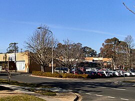 Waramanga shopping centre | |||||||||||||||
 Waramanga | |||||||||||||||
| Coordinates | 35°21′11″S 149°03′47″E / 35.353°S 149.063°E | ||||||||||||||
| Population | 2,785 (2021 census)[1] | ||||||||||||||
| • Density | 1,640/km2 (4,240/sq mi) | ||||||||||||||
| Established | 1968 | ||||||||||||||
| Postcode(s) | 2611 | ||||||||||||||
| Elevation | 606 m (1,988 ft) | ||||||||||||||
| Area | 1.7 km2 (0.7 sq mi) | ||||||||||||||
| Location |
| ||||||||||||||
| District | Weston Creek | ||||||||||||||
| Territory electorate(s) | Murrumbidgee | ||||||||||||||
| Federal division(s) | Bean | ||||||||||||||
| |||||||||||||||
Waramanga was established in the late-1960s and was named after the Warumungu people of Central Australia.[2] Streets in the suburb of Warramanga are named after Australian Aborignal people.
History edit
The Weston Creek district was part of Yarralumla Station, a 40,000 acre (162 km2) property dating back to 1828. It was resumed by the Commonwealth in 1913 from Frederick Campbell who bought the property in 1881. In 1920 9,000 acres (36 km2) of the Woden Valley, including the Weston Creek district, were subdivided for soldier settlement leases. A 1950s map of the district shows four paddocks, Weston paddock, Track paddock, Brown Hill paddock and Oakey Hill paddock intersecting the area which is now the suburb of Waramanga. Long Gully Road ran through the suburb and the nearest homestead was Cooleman on the Kambah Road just west of the present suburb of Fisher. Cooleman was farmed by the Champion family from about 1932. It was previously known as Allawah and was leased to the Anderson family in 1920. Other properties in the district were Avondale and Weston whose homesteads were in the present suburb of Holder, Yamba in the suburb of Phillip and Iloura, Melrose and Yarra Glen in the suburb of Curtin.[3]
In June 1968 the suburb of Waramanga was officially gazetted.[2]
The bushfire which engulfed parts of Canberra on 18 January 2003 flowed out of Mount Taylor Nature Reserve and reached the eastern boundary of the suburb at Badimara Street where it was slowed by residents and stopped by a contrary wind. For more information about the bushfire see Canberra bushfires of 2003.
Demographics edit
At the 2021 census, Waramanga had a population of 2,785 people. Waramanga residents had a median age of 38 compared to a Canberra median of 35. The median weekly personal income for people aged 15 years was A$1,179 a week, compared to a Canberra wide figure of $1,203 and an Australia wide figure of $805.[1]
The population of Waramanga is predominantly Australian-born, 74.0% of people being born in Australia. With 3.4% of the population, the second most common birthplace is the England. Accommodation is mostly separate houses (77.3%), with semi detached, row or terrace houses and townhouses comprising 19.6%.[1]
Politics edit
Waramanga is located in the federal House of Representatives electorate of Bean, which is the largest division in the Australian Capital Territory. The electorate of Bean is represented by David Smith of the Australian Labor Party.
In the ACT Legislative Assembly, Waramanga is part of the electorate of Murrumbidgee. The electorate elects five members on the basis of proportional representation.
Geology edit
Deakin Volcanics green grey, red, and purple rhyodacite with spherulitic texture fill up Warramanga from beneath.[4]
Suburb amenities edit


Waramanga has a busy local shopping centre on the corner of Damala Street and Waramanga Place. The centre contains a cafe, supermarket, bakery,’Village’ cafe, hairdresser, beauty salon, chemist, newsagency, medical centre and postal agency.
Educational institutions located in Waramanga edit
- Government schools
- Waramanga Preschool on Nemarang Crescent.
- Arawang Primary[5] on Nemarang Crescent.
- Mount Stromlo High School[6] on the corner of Badimara Street and Namatjira Drive.
- Non-government schools and colleges
- St John Vianney Primary[7] in Namatjira Drive.
- Alliance College of Australia in Namatjira Drive.
Churches in Waramanga edit
- St John Vianney Parish Centre of the Catholic Church in Australia in Namatjira Drive.
- Woden Valley Alliance Church[8] of the Christian and Missionary Alliance[9] in Namatjira Drive.
- Canberra Korean Manse of the Uniting Church in Australia[10] in Badimara Street.
Health facilities in Waramanga edit
- Weston Creek Veterinary Hospital[11] in Badimara Street.
- Waramanga Medical Centre located in the shopping centre on the corner of Damala Street and Waramanga Place.
Public Transport in Waramanga edit
- ACTION Buses run regular services to Waramanga. Route 63 services most of Waramanga, on its way between the nearest major bus interchange at Woden Town Centre and the Weston Creek Centre.[12] Routes 70 and 71 provides a link to Tuggeranong Town Centre via Kambah.[13][14]
- No other public transportation is available, apart from taxis.
Waramanga has extensive open spaces with playing fields on the western side of the suburb, several neighbourhood parks and pedestrian parkland along the ridge in the centre of the suburb. Waramanga is adjacent to Mount Taylor Nature Reserve, part of Canberra Nature Park with grassland and hillside walking tracks and sweeping views across Woden and Tuggeranong Valleys.[15]
References edit
- ^ a b c Australian Bureau of Statistics (28 June 2022). "Waramanga". 2021 Census QuickStats. Retrieved 3 September 2022.
- ^ a b "Suburb Name search results". ACT Environment and Sustainable Development. Retrieved 14 February 2014.
- ^ Douglas, F (1996). Not without my corsets!: oral histories of the families who farmed soldier settler blocks in the Woden Valley from 1920 to 1963. O'Connor, ACT. ISBN 0-646-42672-9
- ^ Henderson, G. A. M.; Matveev, G. (1980). Geology of Canberra, Queanbeyan and Environs (Map). 1:50000.
- ^ "arawangps.act.edu.au". arawangps.act.edu.au. Retrieved 24 March 2013.
- ^ "stromlohs.act.edu.au". stromlohs.act.edu.au. Retrieved 24 March 2013.
- ^ "sjv.cg.catholic.edu.au". sjv.cg.catholic.edu.au. Retrieved 24 March 2013.
- ^ "wvac.org.au". wvac.org.au. Retrieved 24 March 2013.
- ^ "cma.org.au". cma.org.au. Retrieved 24 March 2013.
- ^ "unitingchurch.org.au". unitingchurch.org.au. Retrieved 24 March 2013.
- ^ "wcvh.com.au". wcvh.com.au. Retrieved 24 March 2013.
- ^ Route 63 Transport Canberra
- ^ Route 70 Transport Canberra
- ^ Route 71 Transport Canberra
- ^ "Canberra Nature Park". ACT Territory and Municipal Services. Retrieved 14 February 2014.
External links edit
- Weston Creek Community Council (includes map of area)
- Canberra history