


Summary
Warstein ([ˈvaːɐ̯ˌʃtaɪn] ⓘ) is a municipality with town status in the district of Soest, in North Rhine-Westphalia, Germany. It is located at the north end of Sauerland.
Warstein | |
|---|---|
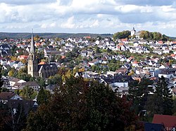 View of Warstein with St. Pancratius and the Old Church | |
 Coat of arms | |
Location of Warstein within Soest district  | |
 Warstein  Warstein | |
| Coordinates: 51°27′N 8°21′E / 51.450°N 8.350°E | |
| Country | Germany |
| State | North Rhine-Westphalia |
| Admin. region | Arnsberg |
| District | Soest |
| Subdivisions | 9 |
| Government | |
| • Mayor (2020–25) | Thomas Schöne[1] (Ind.) |
| Area | |
| • Total | 157.91 km2 (60.97 sq mi) |
| Elevation | 310 m (1,020 ft) |
| Population (2022-12-31)[2] | |
| • Total | 24,647 |
| • Density | 160/km2 (400/sq mi) |
| Time zone | UTC+01:00 (CET) |
| • Summer (DST) | UTC+02:00 (CEST) |
| Postal codes | 59581 |
| Dialling codes | 02902 (Warstein), 02925 (Allagen) |
| Vehicle registration | SO |
| Website | www.warstein.de |
Geography edit

Warstein is located north of the Arnsberger Wald (forest), at a brook called Wäster. The area south of the city is mostly forested; the lightly forested Haarstrang mountain is to the north. The river Möhne flows between these two areas. The highest elevation is 581 m (1,906 ft) in the south of the city near a hill called Stimm Stamm; the lowest elevation is 216 m (709 ft) in the village Waldhausen in the north.
Neighbouring municipalities edit
The following municipalities, some with town status, border Warstein (clockwise, beginning in the north): Anröchte, Rüthen (town), Bestwig, Meschede (town), Arnsberg (town), Möhnesee, Bad Sassendorf. Of these, Bestwig and Meschede are in the district of Hochsauerlandkreis, on Warstein's (and, thus, Soest district's) southern border.
Subdivisions edit
While named for the main settled portion within its 157.91 square kilometres (60.97 sq mi) total area, the town can be roughly divided into the following subdivisions (German: Ortsteil):
|
|
History edit
Evidence of human life was found in the Bilstein Cave between Warstein and Hirschberg. Warstein was first mentioned officially in 1072. Historians once thought Warstein was organized as an official town in 1276, but its exact charter date is unclear. Likely, it was founded between 1276 and 1296 by the Archbishop of Cologne, Siegfried von Westerburg.[3] In the Middle Ages, Warstein was part of the Hanseatic League, a trade association for guilds, a very important international trading association at that time. A fire in 1802 destroyed a significant portion of the town. After that the town centre was moved to the Wester brook. In 1844, the Amt Warstein was founded. In 1975, Warstein and the other eight independent villages merged to form the new borough of Warstein.
The decrease of population in Warstein since 1998:
- 1998: 29,102
- 1999: 29,084
- 2000: 29,028
- 2001: 29,007
- 2002: 29,012
- 2003: 28,762
- 2004: 28,629
List of mayors edit
- 1999–2004: Georg Juraschka (SPD)
- 2004–2015: Manfred Gödde (BG)
- 2015–incumbent: Thomas Schöne (CDU)
International relations edit
Warstein is twinned with:
 Saint-Pol-sur-Ternoise, France - twinned in 1964
 Wurzen, Saxony, Germany - twinned 3 October 1990
 Hebden Royd, United Kingdom - twinned November 1995
 Pietrapaola, Italy - an official friendship since 2001
Economy edit

The largest employer in Warstein is the Warsteiner brewery, founded in 1753. It is one of the largest breweries in Germany. Second largest employer is steel mill operator Siepmann-Werke, founded in 1891. In addition to its mills, the overall Siepmann Group head office is located in Warstein.[4]
Notable people edit
- Friedhelm Hillebrand (born 1940), engineer
- Karl-Werner Schulte (born 1946), professor
- Hugo Siepmann (1868-1950), industrialist
- Emil Siepmann (1863-1950), industrialist an namesake of Emil-Siepmann-Strasse
- Georg Dassel (1852-1934), quarry owner and industrialist
- Jan-Lennard Struff (born 1990), tennis player notable for becoming the first lucky loser to reach a Masters 1000 final
Literature edit
- Heppekausen, Wolfgang; Clewing, Christian: Warstein: Bilder einer sauerländischen Stadt. Selbstverlag, Warstein 2001. ISBN 3-00-008520-3
- Gerte, Franz im Auftrag der Volkshochschule Möhne-Lippe: Wie war das?: Belecke 1923–1948. Selbstverlag, Belecke 2001.
- Bamberg, Fritz: Die neue Stadt Warstein in alten Ansichten. Europäische Bibliothek, Zaltbommel 1986. ISBN 90-288-3363-3
- Bender, Josef: Geschichte der Stadt Warstein. Stein, Werl 1973. ISBN 3-920980-03-4
- Sandgathe, Günther: Die Stadt Warstein im Dreissigjährigen Krieg. Selbstverlag, Warstein 1971.
References edit
- ^ Wahlergebnisse in NRW Kommunalwahlen 2020, Land Nordrhein-Westfalen, accessed 30 June 2021.
- ^ "Bevölkerung der Gemeinden Nordrhein-Westfalens am 31. Dezember 2022 – Fortschreibung des Bevölkerungsstandes auf Basis des Zensus vom 9. Mai 2011" (in German). Landesbetrieb Information und Technik NRW. Retrieved 20 June 2023.
- ^ "Warstein - City - ILC". stadtbuecher.de. Retrieved 2023-04-14.
- ^ "About | Quality From the Heart of Warstein". Siepmann-Werke GmbH & Co. KG. Retrieved 2021-11-18.
External links edit
- Official site (in German)
- Warsteiner brewery homepage (in German)