


Summary
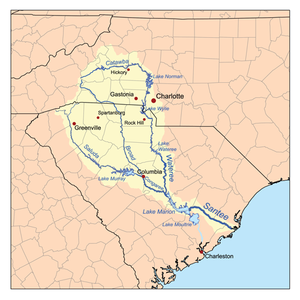
The Wateree River, about 75 mi (120 km) long, is a tributary of the Santee River in central South Carolina in the United States, which flows to the Atlantic Ocean. It was named for the Wateree Native Americans, a tribe who had migrated to this area from western North Carolina. They lived here until the early 18th century, when they were set upon and displaced by mostly English settlers during the Yamasee War. Survivors merged with the larger Catawba people, becoming extinct as a tribe.[3]
| Wateree River | |
|---|---|
 Wateree River from the Palmetto Trail near Eastover, South Carolina | |
 The Wateree River | |
 Location of the mouth of Wateree River in South Carolina | |
| Location | |
| Country | United States |
| States | South Carolina |
| Counties | Edgefield, Fairfield, Kershaw, Sumter, Richland |
| Physical characteristics | |
| Source | Catawba River |
| • location | Liberty Hill, South Carolina |
| • coordinates | 34°28′04″N 80°53′17″W / 34.46778°N 80.88806°W[1] |
| • elevation | 223 ft (68 m) |
| Mouth | Santee River |
• location | Fort Motte, South Carolina |
• coordinates | 33°44′39″N 80°37′09″W / 33.74417°N 80.61917°W[1] |
• elevation | 75 ft (23 m)[1] |
| Length | 75 mi (121 km)}[2] |
| Basin features | |
| Progression | Wateree → Santee → Atlantic Ocean |
| River system | Catawba River |
Course edit
The Wateree River is a continuation of the Catawba River, which flows from the Blue Ridge Mountains in North Carolina; this river had the different names of Catawba and Wateree assigned to different sections by different groups of settlers.
Today the name change is marked at the point where Wateree Creek empties into Lake Wateree. This is a manmade lake formed by Wateree Hydro Station Dam, a Duke Energy hydroelectric project built in the 20th century in Kershaw County, South Carolina.
The Wateree flows generally southward through Kershaw County and along the common boundary of Richland and Sumter counties, past the Piedmont town of Camden. It joins the Congaree River to form the Santee River about 35 mi (55 km) southeast of Columbia.
Crossings edit
The following is a list of crossings along the short length of the Wateree
- US Route 1/US 601 in Camden & Lugoff
- Railroad bridge in Camden
- Interstate 20 in Camden
- Garner's Ferry Road US 378 near Stateburg & Eastover
- Two railroad bridges near the confluence with the Congaree River near Eastover
See also edit
References edit
- ^ a b c "Wateree River". Geographic Names Information System. United States Geological Survey, United States Department of the Interior. June 17, 1980. Retrieved December 28, 2020.
- ^ "Wateree River". Visit Camden. Retrieved 5 June 2020.
- ^ Swanton, John Reed (1952). The Indian Tribes of North America. US Government Printing Office. p. 102. ISBN 978-0-8063-1730-4.
Sources edit
Further reading edit
- Lewis, Kenneth E. The Carolina Backcountry Venture: Tradition, Capital, and Circumstance in the Development of Camden and the Wateree Valley, 1740—1810 (University of South Carolina Press, 2017. xviii, 436 pp.