
KNOWPIA
WELCOME TO KNOWPIA

Wattwiller 
Summary
Wattwiller (French pronunciation: [vatvilɛʁ] ⓘ; Alemannic German: Wǎttwillr; German: Wattweiler) is a commune in the Haut-Rhin department of the Grand Est region, which lies in the north-eastern part of France.
Wattwiller
Wǎttwillr | |
|---|---|
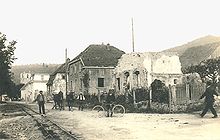
 A general view of Wattwiller | |
 Coat of arms | |
Location of Wattwiller .mw-parser-output .locmap .od{position:absolute}.mw-parser-output .locmap .id{position:absolute;line-height:0}.mw-parser-output .locmap .l0{font-size:0;position:absolute}.mw-parser-output .locmap .pv{line-height:110%;position:absolute;text-align:center}.mw-parser-output .locmap .pl{line-height:110%;position:absolute;top:-0.75em;text-align:right}.mw-parser-output .locmap .pr{line-height:110%;position:absolute;top:-0.75em;text-align:left}.mw-parser-output .locmap .pv>div{display:inline;padding:1px}.mw-parser-output .locmap .pl>div{display:inline;padding:1px;float:right}.mw-parser-output .locmap .pr>div{display:inline;padding:1px;float:left}html.skin-theme-clientpref-night .mw-parser-output .od,html.skin-theme-clientpref-night .mw-parser-output .od .pv>div,html.skin-theme-clientpref-night .mw-parser-output .od .pl>div,html.skin-theme-clientpref-night .mw-parser-output .od .pr>div{background:#000;color:#fff}html.skin-theme-clientpref-night .mw-parser-output .locmap{filter:grayscale(0.6)}@media(prefers-color-scheme:dark){html.skin-theme-clientpref-os .mw-parser-output .locmap{filter:grayscale(0.6)}html.skin-theme-clientpref-os .mw-parser-output .od,html.skin-theme-clientpref-os .mw-parser-output .od .pv>div,html.skin-theme-clientpref-os .mw-parser-output .od .pl>div,html.skin-theme-clientpref-os .mw-parser-output .od .pr>div{background:#000;color:#fff}}  Wattwiller  Wattwiller | |
| Coordinates: 47°50′13″N 7°10′51″E / 47.8369°N 7.1808°E | |
| Country | France |
| Region | Grand Est |
| Department | Haut-Rhin |
| Arrondissement | Thann-Guebwiller |
| Canton | Cernay |
| Intercommunality | Thann-Cernay |
| Government | |
| • Mayor (2020–2026) | Mathieu Ermel[1] |
| Area 1 | 13.61 km2 (5.25 sq mi) |
| Population (2021)[2] | 1,668 |
| • Density | 120/km2 (320/sq mi) |
| Time zone | UTC+01:00 (CET) |
| • Summer (DST) | UTC+02:00 (CEST) |
| INSEE/Postal code | 68359 /68700 |
| Elevation | 266–1,121 m (873–3,678 ft) (avg. 360 m or 1,180 ft) |
| 1 French Land Register data, which excludes lakes, ponds, glaciers > 1 km2 (0.386 sq mi or 247 acres) and river estuaries. | |
Located near the Vosges mountain rocky spur of Hartmannswillerkopf, Wattwiller was a strategic village in the Alsace, and suffered attacks in or near it during the Thirty Years' War and in both World Wars.
Nowadays Wattwiller is best known for its mineral water. Wattwiller is also located on the Alsace Wine Route.
-
 Mineral water plant

Population edit
| Year | Pop. | ±% p.a. |
|---|---|---|
| 1968 | 1,020 | — |
| 1975 | 1,135 | +1.54% |
| 1982 | 1,186 | +0.63% |
| 1990 | 1,506 | +3.03% |
| 1999 | 1,593 | +0.63% |
| 2007 | 1,721 | +0.97% |
| 2012 | 1,731 | +0.12% |
| 2017 | 1,634 | −1.15% |
| 2020 | 1,678 | +0.89% |
| Source: INSEE[3] | ||
See also edit
References edit
- ^ "Répertoire national des élus: les maires" (in French). data.gouv.fr, Plateforme ouverte des données publiques françaises. 13 September 2022.
- ^ "Populations légales 2021". The National Institute of Statistics and Economic Studies. 28 December 2023.
- ^ Population en historique depuis 1968, INSEE
Wikimedia Commons has media related to Wattwiller.