


Summary
A wave cloud is a cloud form created by atmospheric internal waves.


Formation edit
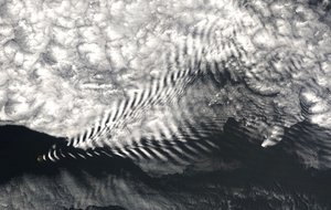
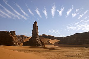
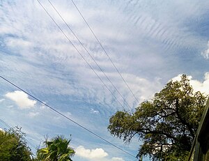
The atmospheric internal waves that form wave clouds are created as stable air flows over a raised land feature such as a mountain range, and can form either directly above or in the lee of the feature. As an air mass travels through the wave, it undergoes repeated uplift and descent. If there is enough moisture in the atmosphere, clouds will form at the cooled crests of these waves. In the descending part of the wave, those clouds will evaporate due to adiabatic heating, leading to the characteristic clouded and clear bands. The cloud base on the leeward side is higher than on the windward side, because precipitation on the windward side removes water from the air.[1]
It is possible that simple convection from mountain summits can also form wave clouds. This occurs as the convection forces a wave or lenticular wave cloud into the more stable air above.[2]
Importance edit
Climate modeling edit
Wave clouds are typically mid- to upper-tropospheric ice clouds. They are relatively easy to study, because they are quite consistent. As a result, they are being analyzed to increase our understanding of how these upper-level ice clouds influence the Earth's radiation budget. Understanding this can improve climate models.[3]
Recreation edit
The streamlines in these clouds have the steepest slope a few kilometers downwind of the lee slope of a mountain. It is in these regions of highest vertical velocity that sailplanes can reach record-breaking altitudes.[1]
Structure edit
In an ideal model, a wave cloud consists of supercooled liquid water at the lower part, a mixed phase of frozen and liquid water near the ridge, and ice beginning slightly below the ridge and extending downstream. However, this doesn't always occur. Wave cloud structure ranges from smooth and simple, to jumbled phases occurring randomly.[1] Often, ice crystals can be found downwind of the waves. Whether this happens depends on the saturation of the air. The composition of the ice is currently an active topic of study. The main mechanism for ice formation is homogeneous nucleation. The ice crystals are mostly small spheroidal and irregular-shaped particles. Ice columns make up less than 1%,[4] and plates are virtually nonexistent.[3] Multi-level mountain wave clouds form when the moisture in the air above the mountain is located in distinct layers, and vertical mixing is inhibited.
See also edit
References edit
- ^ a b c Wallace, John M., Hobbs, Peter V. Atmospheric Science, and Introductory Survey. San Diego, CA: Academic Press, 1977.
- ^ Worthington, R. M. "Lenticular wave cloud above the convective boundary layer of the Rocky Mountains," Weather 57(2002):87–90.
- ^ a b Baker, B. A., Lawson, R. P. (2006) In Situ Observations of the Microphysical Properties of Wave, Cirrus, and Anvil Clouds. Wave clouds got their name because they look like waves. Part I: Wave Clouds. Journal of the Atmospheric Sciences: Vol. 63, No. 12 pp. 3160–3185
- ^ "Cloud Crystals - Columns & Plates - Atmospheric Optics". 16 September 2023.