
KNOWPIA
WELCOME TO KNOWPIA

Wemaers-Cappel 
Summary
Wemaers-Cappel is a commune in the Nord department in northern France.[3]
Wemaers-Cappel | |
|---|---|
 The town hall in Wemaers-Cappel | |
 Coat of arms | |
Location of Wemaers-Cappel .mw-parser-output .locmap .od{position:absolute}.mw-parser-output .locmap .id{position:absolute;line-height:0}.mw-parser-output .locmap .l0{font-size:0;position:absolute}.mw-parser-output .locmap .pv{line-height:110%;position:absolute;text-align:center}.mw-parser-output .locmap .pl{line-height:110%;position:absolute;top:-0.75em;text-align:right}.mw-parser-output .locmap .pr{line-height:110%;position:absolute;top:-0.75em;text-align:left}.mw-parser-output .locmap .pv>div{display:inline;padding:1px}.mw-parser-output .locmap .pl>div{display:inline;padding:1px;float:right}.mw-parser-output .locmap .pr>div{display:inline;padding:1px;float:left}html.skin-theme-clientpref-night .mw-parser-output .od,html.skin-theme-clientpref-night .mw-parser-output .od .pv>div,html.skin-theme-clientpref-night .mw-parser-output .od .pl>div,html.skin-theme-clientpref-night .mw-parser-output .od .pr>div{background:#000;color:#fff}html.skin-theme-clientpref-night .mw-parser-output .locmap{filter:grayscale(0.6)}@media(prefers-color-scheme:dark){html.skin-theme-clientpref-os .mw-parser-output .locmap{filter:grayscale(0.6)}html.skin-theme-clientpref-os .mw-parser-output .od,html.skin-theme-clientpref-os .mw-parser-output .od .pv>div,html.skin-theme-clientpref-os .mw-parser-output .od .pl>div,html.skin-theme-clientpref-os .mw-parser-output .od .pr>div{background:#000;color:#fff}}  Wemaers-Cappel  Wemaers-Cappel | |
| Coordinates: 50°48′29″N 2°26′19″E / 50.8081°N 2.4386°E | |
| Country | France |
| Region | Hauts-de-France |
| Department | Nord |
| Arrondissement | Dunkerque |
| Canton | Wormhout |
| Intercommunality | Flandre Intérieure |
| Government | |
| • Mayor (2020–2026) | Laurence Barrois[1] |
| Area 1 | 4.13 km2 (1.59 sq mi) |
| Population (2021)[2] | 237 |
| • Density | 57/km2 (150/sq mi) |
| Demonym | Wemaers-Cappelois (es) |
| Time zone | UTC+01:00 (CET) |
| • Summer (DST) | UTC+02:00 (CEST) |
| INSEE/Postal code | 59655 /59670 |
| Elevation | 30–75 m (98–246 ft) (avg. 37 m or 121 ft) |
| 1 French Land Register data, which excludes lakes, ponds, glaciers > 1 km2 (0.386 sq mi or 247 acres) and river estuaries. | |
Heraldry edit
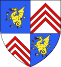 |
The arms of Wemaers-Cappe are blazoned : Quarterly 1&4: Azure, a wyvern Or armed and langued gules; 2&3: Argent, 3 chevrons gules.
|
Population edit
| Year | Pop. | ±% p.a. |
|---|---|---|
| 1968 | 255 | — |
| 1975 | 198 | −3.55% |
| 1982 | 198 | +0.00% |
| 1990 | 186 | −0.78% |
| 1999 | 230 | +2.39% |
| 2007 | 253 | +1.20% |
| 2012 | 249 | −0.32% |
| 2017 | 252 | +0.24% |
| Source: INSEE[4] | ||
See also edit
References edit
- ^ "Répertoire national des élus: les maires". data.gouv.fr, Plateforme ouverte des données publiques françaises (in French). 2 December 2020.
- ^ "Populations légales 2021". The National Institute of Statistics and Economic Studies. 28 December 2023.
- ^ INSEE commune file
- ^ Population en historique depuis 1968, INSEE
Wikimedia Commons has media related to Wemaers-Cappel.