


Summary
Westwood is a station on the Long Island Rail Road's West Hempstead Branch serving the villages of Malverne and Lynbrook, New York. The station platform is located on Foster Avenue in Malverne, with parking facilities on both the Malverne (Foster Avenue at Motley Street) and Lynbrook (Whitehall Street at Whittier Street) sides of the tracks. It has no station building other than a pair of open shelters, the larger one on the Malverne side of the tracks. It also features a gated at-grade pedestrian crossing,[3] one of only a few stations on the Long Island Rail Road to feature such crossings.
Westwood | |||||||||||
|---|---|---|---|---|---|---|---|---|---|---|---|
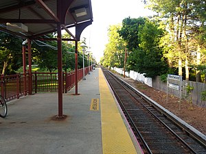 View from the platform, facing north. | |||||||||||
| General information | |||||||||||
| Location | Foster Avenue & Motley Street Malverne, New York | ||||||||||
| Coordinates | 40°40′05.8″N 73°40′53.1″W / 40.668278°N 73.681417°W | ||||||||||
| Owned by | Long Island Rail Road | ||||||||||
| Line(s) | West Hempstead Branch | ||||||||||
| Distance | 1.4 mi (2.3 km) from Valley Stream[1] | ||||||||||
| Platforms | 1 side platform | ||||||||||
| Tracks | 1 | ||||||||||
| Construction | |||||||||||
| Parking | Yes; Village of Malverne & Lynbrook permits required | ||||||||||
| Bicycle facilities | Yes; Bicycle Racks | ||||||||||
| Accessible | Yes | ||||||||||
| Other information | |||||||||||
| Fare zone | 4 | ||||||||||
| History | |||||||||||
| Opened | September 1929 | ||||||||||
| Rebuilt | 1955 | ||||||||||
| Electrified | October 19, 1926 750 V (DC) third rail | ||||||||||
| Passengers | |||||||||||
| 2006 | 711[2] | ||||||||||
| Services | |||||||||||
| |||||||||||
No buses connect to Westwood station. A basketball court can be found on the Malverne side of the station between the platform and parking lot.[4]
History edit
Before the establishment of Westwood station, the station itself was the site of a junction of two freight sidings in Lynbrook that existed only in 1924 both of which were abandoned in September of that year. The line was electrified on October 19, 1926 and the station itself was established in September 1929. The small station house had a single platform on the Malverne side, as well as an un-gated pedestrian crossing, and a pedestrian bridge over the tracks which existed only until 1938.[5] By 1955, the station house was gutted, leaving only the roof and the frame, thus transforming it into an open shelter.[6] At some point, an identical open shelter was built on the Lynbrook side of the tracks, which had a separate color scheme[7] from the Malverne shelter[8] until the 21st century.
Platform and track edit
This station has one four-car-long side platform on the west side of the single track, which was converted into a high-level platform in fall 1973.[9]
| Side platform, doors will open on the left or right | |
| Track 1 | ← West Hempstead Branch weekdays toward Valley Stream, Grand Central Madison, Atlantic Terminal, or Penn Station (St. Albans) West Hempstead Branch toward West Hempstead (Malverne) → |
Gallery edit
- Westwood station
-
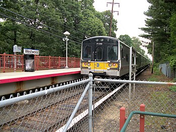 A train bound for West Hempstead as seen from the Lynbrook side of the tracks.
 -
 The station, as seen from an adjacent basketball court.
 -
 The pedestrian grade crossing at the station.
 -
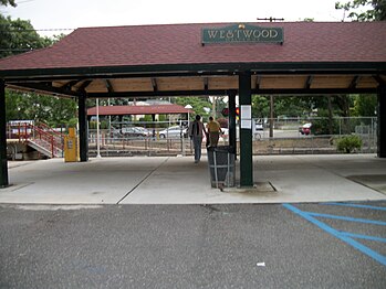 Westwood station's Malverne shelter. The Lynbrook shelter can be seen across the tracks.


References edit
- ^ Long Island Rail Road (May 14, 2012). "TIMETABLE No. 4" (PDF). p. VII. Retrieved August 7, 2022.
- ^ Average weekday, 2006 LIRR Origin and Destination Study
- ^ Westwood's at-grade Pedestrian Crossing looking from Lynbrook into Malverne (Unofficial LIRR History Website)[usurped]
- ^ DanTD (June 10, 2010). Westwood Station from the Basketball Court (photograph). Retrieved July 15, 2013.
{{cite AV media}}: External link in|people= - ^ February 23, 1946 view of Westwood Station House in Malverne from across the tracks in Lynbrook, by William Gilligan (TrainsAreFun)
- ^ LIRR station History (TrainsAreFun.com)
- ^ Westwood Station on the Lynbrook side in February 1999 (Unofficial LIRR History Website)[usurped]
- ^ Westwood Station on the Malverne side in June 2006 (Unofficial LIRR History Website)[usurped]
- ^ Westwood Shelter Track View High-level platforms under construction September 27, 1973 George Povall collection (TrainsAreFun)
External links edit
![]() Media related to Westwood (LIRR station) at Wikimedia Commons
Media related to Westwood (LIRR station) at Wikimedia Commons
- Westwood – LIRR
- Westwood LIRR timetable
- West Hempstead Branch Stations (Unofficial LIRR History Website)[usurped]
- Station from Google Maps Street View
- Platform from Google Maps Street View
- The gutted Station House from Google Maps Street View