
KNOWPIA
WELCOME TO KNOWPIA

Wetteren 
Summary
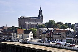
Wetteren (Dutch pronunciation: [ˈʋɛtərə(n)]) is a municipality in the Belgian province of East Flanders, comprising the towns of Massemen, Westrem and Wetteren proper. In 2021 it had a population of 26,206. Its total area is 36.68 km2.[2]
Wetteren | |
|---|---|
 | |
 Flag  Coat of arms | |
Location of Wetteren .mw-parser-output .locmap .od{position:absolute}.mw-parser-output .locmap .id{position:absolute;line-height:0}.mw-parser-output .locmap .l0{font-size:0;position:absolute}.mw-parser-output .locmap .pv{line-height:110%;position:absolute;text-align:center}.mw-parser-output .locmap .pl{line-height:110%;position:absolute;top:-0.75em;text-align:right}.mw-parser-output .locmap .pr{line-height:110%;position:absolute;top:-0.75em;text-align:left}.mw-parser-output .locmap .pv>div{display:inline;padding:1px}.mw-parser-output .locmap .pl>div{display:inline;padding:1px;float:right}.mw-parser-output .locmap .pr>div{display:inline;padding:1px;float:left}html.skin-theme-clientpref-night .mw-parser-output .od,html.skin-theme-clientpref-night .mw-parser-output .od .pv>div,html.skin-theme-clientpref-night .mw-parser-output .od .pl>div,html.skin-theme-clientpref-night .mw-parser-output .od .pr>div{background:#000;color:#fff}html.skin-theme-clientpref-night .mw-parser-output .locmap{filter:grayscale(0.6)}@media(prefers-color-scheme:dark){html.skin-theme-clientpref-os .mw-parser-output .locmap{filter:grayscale(0.6)}html.skin-theme-clientpref-os .mw-parser-output .od,html.skin-theme-clientpref-os .mw-parser-output .od .pv>div,html.skin-theme-clientpref-os .mw-parser-output .od .pl>div,html.skin-theme-clientpref-os .mw-parser-output .od .pr>div{background:#000;color:#fff}}  Wetteren Location in Belgium
Location of Wetteren in East Flanders 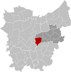 | |
| Coordinates: 51°00′N 03°53′E / 51.000°N 3.883°E | |
| Country | |
| Community | Flemish Community |
| Region | Flemish Region |
| Province | East Flanders |
| Arrondissement | Dendermonde |
| Government | |
| • Mayor | Albert De Geyter (CD&V) |
| • Governing party/ies | CD&V, spa plus, Groen & CO, EEN Wetteren |
| Area | |
| • Total | 37.02 km2 (14.29 sq mi) |
| Population (2018-01-01)[1] | |
| • Total | 25,477 |
| • Density | 690/km2 (1,800/sq mi) |
| Postal codes | 9230 |
| NIS code | 42025 |
| Area codes | 09 |
| Website | www.wetteren.be |

Educational institutions edit
- Gemeenschapsonderwijs [1] Noordlaan 10, Wetteren
- Basischool Scheppers [2] Cooppallaan 82, Wetteren
- Basisschool Sint-Gertrudis [3] F. Leirensstraat 31, Wetteren
- Basisschool Sint-Jozef [4] Wegvoeringstraat 59 a, Wetteren
- Scheppersinstituut [5] Cooppaallaan 128, Wetteren
- Sint-Gertrudiscollege [6] Wegvoeringstraat 21, Wetteren
- Sint-Jozefinstituut [7] Wegvoeringstraat 59 a, Wetteren
- Mariagaard [8] Oosterzelsesteenweg 80, Wetteren
Notable people edit
- Julien De Wilde (b. Wetteren, 7 January 1967), businessman
- Émile Pierre Joseph Storms (1846-1918) Explorer of Congo Free State, General
- Cecile Bombeek, serial killer
- Ben Mertens, snooker player
References edit
External links edit
 Media related to Wetteren at Wikimedia Commons
- Official website (in Dutch)
- Chiro Overschelde Wetteren Liefkenshoek 24, Wetteren
- Scouts & Gidsen Vlaanderen Wetteren (St.-Jan) Groenstraat 33, Wetteren
- Scouts & Gidsen Vlaanderen Wetteren (Prins Boudewijn) Groene Wegel, Wetteren
- Chess Club De Wetterse Vrijpion Warandelaan 14, Wetteren