


Summary
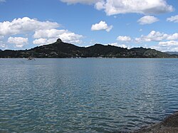
Whangaroa, also known as Whangaroa Village to distinguish it the larger area of the former Whangaroa County, is a settlement on Whangaroa Harbour in the Far North District of New Zealand. It is 8 km north-west of Kaeo and 35 km north-west of Kerikeri. The harbour is almost landlocked and is popular both as a fishing spot in its own right and as a base for deep-sea fishing.[3]
Whangaroa | |
|---|---|
 Whangaroa | |
 | |
| Coordinates: 35°3′8″S 173°44′31″E / 35.05222°S 173.74194°E | |
| Country | New Zealand |
| Region | Northland Region |
| District | Far North District |
| Ward | Bay of Islands/Whangaroa |
| Electorates | |
| Government | |
| • Territorial Authority | Far North District Council |
| • Regional council | Northland Regional Council |
| Area | |
| • Total | 1.27 km2 (0.49 sq mi) |
| Population (June 2023)[2] | |
| • Total | 150 |
| • Density | 120/km2 (310/sq mi) |
History edit
The harbour was the scene of one of the most notorious incidents in early New Zealand history, the Boyd massacre. In December 1809 almost all the crew and 70 passengers were killed as utu (revenge) for the mistreatment of Te Ara, the son of a Ngāti Uru chief, who had been in the crew of the ship. Several days later the ship was burnt out after gunpowder was accidentally ignited. Relics of the Boyd are now in a local museum.
On 16 July 1824 on a voyage to Sydney from Tahiti, the crew and passengers of the colonial schooner Endeavour (Capt John Dibbs) stopped in Whangaroa Harbour. An altercation with the local Māori Ngāti Pou hapū (subtribe) of the Ngā Puhi iwi resulted in an incident where Maori warriors took control of the Endeavour and menaced the crew. The situation was defused by the timely arrival of the Ngāti Uru chief Te Ara, of Boyd fame.[4]
In February 1827, the famous Ngā Puhi chief Hongi Hika was engaged in warfare against the tribes of Whangaroa.[5] Acting contrary to the orders of Hongi Hika, some of his warriors plundered and burnt Wesleydale, the Wesleyan mission that had been established in June 1823 at Kaeo,[6] nine kilometres from Whangaroa. The missionaries, Rev Turner and his wife and three children, together with Rev. Messrs, Hobbs and Stack, and Mr Wade and wife, were 'compelled to flee from Whangarooa (sic) for their lives'. They were conveyed by ship to Sydney, NSW.[7] During a skirmish Hongi Hika was shot in the chest by one of his warriors.[6] On 6 March 1828 Hongi Hika died at Whangaroa.[8] There is no actual evidence that Hongi himself plundered the mission; he was busily pursuing the enemy and being wounded. Nor is there any direct evidence to implicate anybody else [9] An alternate idea was put forward by William Williams of the CMS. " It appears beyond doubt, though our Wesleyan Friends are loath to believe it, that it was their own chief, Tepui, was the instigator of the whole business".[10] The local Ngatiuru had made the land available to the mission. For years the missionaries had lived amongst them and grown prosperous while the tribe still ate fern root. There was no prospect of the missionaries moving on and no prospect of them becoming acceptable neighbours. They had not joined the tribe. They had set up their own tribe which was steadily wearing down the authority of the Ngatiuru leadership. [11]
By the latter 19th century, the Whangaroa Harbour had become an important location for the kauri gum digging trade.[12]
Demographics edit
Statistics New Zealand describes Whangaroa as a rural settlement. It covers 1.27 km2 (0.49 sq mi)[1] and had an estimated population of 150 as of June 2023,[2] with a population density of 118 people per km2. Whangaroa is part of the larger Whakarara statistical area.[13]
| Year | Pop. | ±% p.a. |
|---|---|---|
| 2006 | 105 | — |
| 2013 | 102 | −0.41% |
| 2018 | 144 | +7.14% |
| Source: [14] | ||
Whangaroa had a population of 144 at the 2018 New Zealand census, an increase of 42 people (41.2%) since the 2013 census, and an increase of 39 people (37.1%) since the 2006 census. There were 72 households, comprising 78 males and 66 females, giving a sex ratio of 1.18 males per female. The median age was 62.5 years (compared with 37.4 years nationally), with 12 people (8.3%) aged under 15 years, 3 (2.1%) aged 15 to 29, 69 (47.9%) aged 30 to 64, and 54 (37.5%) aged 65 or older.
Ethnicities were 87.5% European/Pākehā, 14.6% Māori, 2.1% Pacific peoples, 2.1% Asian, and 2.1% other ethnicities. People may identify with more than one ethnicity.
Of those people who chose to answer the census's question about religious affiliation, 50.0% had no religion, 35.4% were Christian, 2.1% were Hindu and 2.1% had Māori religious beliefs.
Of those at least 15 years old, 24 (18.2%) people had a bachelor's or higher degree, and 21 (15.9%) people had no formal qualifications. The median income was $24,700, compared with $31,800 nationally. 21 people (15.9%) earned over $70,000 compared to 17.2% nationally. The employment status of those at least 15 was that 36 (27.3%) people were employed full-time, 24 (18.2%) were part-time, and 6 (4.5%) were unemployed.[14]
References edit
- ^ a b "ArcGIS Web Application". statsnz.maps.arcgis.com. Retrieved 4 April 2022.
- ^ a b "Subnational population estimates (RC, SA2), by age and sex, at 30 June 1996-2023 (2023 boundaries)". Statistics New Zealand. Retrieved 25 October 2023. (regional councils); "Subnational population estimates (TA, SA2), by age and sex, at 30 June 1996-2023 (2023 boundaries)". Statistics New Zealand. Retrieved 25 October 2023. (territorial authorities); "Subnational population estimates (urban rural), by age and sex, at 30 June 1996-2023 (2023 boundaries)". Statistics New Zealand. Retrieved 25 October 2023. (urban areas)
- ^ "Whangaroa Travel Guide". Jasons Travel Media.
- ^ Maxwell, Alexander; Roberts, Evan (2014). "The Whangaroa incident, 16 July 1824: A European–Māori encounter and its many incarnations". The Journal of Pacific History. 49 (1): 50–75. doi:10.1080/00223344.2013.869845.
- ^ Caroline Fitzgerald (2011). Te Wiremu - Henry Williams: Early Years in the North. Huia Press. ISBN 978-1-86969-439-5.
- ^ a b Journal of William Williams, March 1st 1827 (Caroline Fitzgerald, 2011)
- ^ The Times, London, article CS118772953 dated 25 June 1827; retrieved 4 May 2004.
- ^ Journal of James Stack, Wesleyan missionary, March 12th 1828 (Caroline Fitzgerald, 2011)
- ^ J.M R.Owens (1974). Prophets In The Wilderness - The Wesleyan Mission to New Zealand 1819-27, p. 108. Auckland University Press
- ^ J.M R.Owens (1974). Prophets In The Wilderness - The Wesleyan Mission to New Zealand 1819-27, p. 109. Auckland University Press.
- ^ J.M R.Owens (1974). Prophets In The Wilderness - The Wesleyan Mission to New Zealand 1819-27, p. 112. Auckland University Press.
- ^ Hayward, Bruce W. (1989). Kauri Gum and the Gumdiggers. The Bush Press. p. 4. ISBN 0-908608-39-X.
- ^ 2018 Census place summary: Whakarara
- ^ a b "Statistical area 1 dataset for 2018 Census". Statistics New Zealand. March 2020. 7000069.
Wises New Zealand Guide, 7th Edition, 1979. p. 508.
External links edit
![]() Whangaroa travel guide from Wikivoyage
Whangaroa travel guide from Wikivoyage
- Photographs of Whangaroa held in Auckland Libraries' heritage collections.