


Summary
Whitfords railway station is a railway station located on the boundary of Padbury and Kingsley, suburbs of Perth, Western Australia. It is on the Joondalup railway line, which is part of the Transperth commuter rail network. It is located in the median of the Mitchell Freeway, and consists of an elevated bus interchange on top of an island platform at ground level. South of Whitfords, trains run every 5 minutes during peak. North of Whitfords, trains run every 10 minutes during peak. Between peak during the day, trains run every 15 minutes. The journey to Perth railway station is 19.8 kilometres (12.3 mi), and takes 19 minutes.
Whitfords | |||||||||||||||
|---|---|---|---|---|---|---|---|---|---|---|---|---|---|---|---|
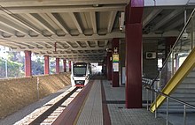
 Southbound view in August 2014 | |||||||||||||||
| General information | |||||||||||||||
| Location | Mitchell Freeway, Padbury Australia | ||||||||||||||
| Coordinates | 31°47′58″S 115°46′56″E / 31.799318°S 115.782348°E | ||||||||||||||
| Owned by | Public Transport Authority | ||||||||||||||
| Operated by | Transperth Trains | ||||||||||||||
| Line(s) | Joondalup line | ||||||||||||||
| Distance | 19.0 kilometres from Perth | ||||||||||||||
| Platforms | 2 platform faces with 1 island platform | ||||||||||||||
| Tracks | 2 | ||||||||||||||
| Bus routes | 19 | ||||||||||||||
| Bus stands | 8 | ||||||||||||||
| Construction | |||||||||||||||
| Structure type | Ground | ||||||||||||||
| Parking | 908 paid car bays | ||||||||||||||
| Accessible | Yes | ||||||||||||||
| Other information | |||||||||||||||
| Station code | JWS 99851 (platform 1) 99852 (platform 2) | ||||||||||||||
| Fare zone | 3 | ||||||||||||||
| History | |||||||||||||||
| Opened | 28 February 1993 | ||||||||||||||
| Electrified | Yes | ||||||||||||||
| Passengers | |||||||||||||||
| March 2018 | 4,200 per day | ||||||||||||||
| Services | |||||||||||||||
| |||||||||||||||
| Location | |||||||||||||||
 | |||||||||||||||
| Location of Whitfords railway station | |||||||||||||||
The station was constructed as part of the Northern Suburbs Transit System project. Construction began in November 1991, and was completed in December 1992. It opened on 28 February 1993, along with most other stations on the Joondalup line.
Description edit
Whitfords railway station is on the boundary of Padbury and Kingsley, suburbs of Perth, Western Australia. It is located in the median of the Mitchell Freeway, just south of Whitfords Avenue. The station consists of an elevated bus interchange on top of an island platform at ground level. The bus interchange is a road looping around a central island. The platform is accessed from the bus interchange island via stairs, a set of escalators, a lift, or a ramp. There are toilets and a kiosk on the bus interchange. It is linked to the east over the freeway by a bus bridge and a pedestrian bridge.[1]
Whitfords station is 19.8 kilometres (12.3 mi),[2] or a 19-minute train journey, from Perth railway station, placing the station in fare zone 3. The adjacent stations are Greenwood railway station to the south, and Edgewater railway station to the north.[3] To the north of the station is a 250 metres (820 ft) long turnback siding.[2]
History edit
Design and construction edit
At the time of the station's design, it was recognised by The Urban Rail Electrification Committee that the placement of bus services in close proximity or direct connection to rail infrastructure was of significant importance. This was evidenced by the Kelmscott and Armadale stations, and the then recently completed Cannington station.[4]
Under the Northern Suburbs Transit System Project, construction on the station was scheduled to commence on 16 November 1991, with completion expected by the end of December 1992. Warwick station being of a similar design was scheduled for construction in synchronisation with Whitfords station.[5]
The station was to include a number of facilities, including a bus concourse to connect with feeder bus services, information booths and offices for railway staff, amenities and services, as well as access services for mobility impaired passengers in line with design requirements of the time. Further to this, pieces of the Passenger Information Network installed at the station included previously unseen electronic displays on the upper bus decks designed to provide drivers with information so they could connect with appointed trains or communicate with bus depot control in the event of delays.[4]
North of the station a headshunt was laid for terminating trains. Even though the siding is in the middle of the Mitchell Freeway with no pedestrian access, Transperth was forced to fence the area in 2006 due to repeated graffiti attacks while trains were briefly in the siding.[6] Car parking spaces were also included as part of the construction project, which included a significant number of on-grade parking bays on the eastern side of the station for commuter use.[4]
The design of the station also allowed for the possible extension of the upper bus deck in a northern direction towards Whitfords Avenue.[4] This extension would provide for five additional regular bus bays, as well as additional pedestrian access if required.[5]
The most interesting part of the station was the upper bus deck. The deck was constructed of precast concrete that was formed off site, which was then transported to the site before being placed atop columns constructed as part of the stations foundations. Precast concrete flooring was then put in place, held in specially formed ridges running the length of the beams. This upper deck was the most expensive structural element of the station, and was the cause of significant attention and consideration as part of the design and construction process.[5]
Whitfords station opened on 28 February 1993.[6][7][8]
After opening edit
A report done by the Department of Transport in 1999 identified Whitfords station as a station where the existing parking provisions were not sufficient for demand. The report said that expansion of parking at Whitfords station should be given priority.[9] In 2002, the car park was expanded to the south.[10] The car park was expanded again, in 2009 and 2010, this time north of Whitfords Avenue.[11][12]
In 2003, the contract for extending the platforms on seven Joondalup line stations, including Whitfords station, was awarded to Lakis Constructions. The platforms on these stations had to be extended by 50 metres (160 ft) to accommodate 150-metre (490 ft) long six car trains, which were planned to enter service. Along with the extensions, the platform edges were upgraded to bring them into line with tactile paving standards.[13] Work on this station began in early 2004,[14] and was complete by July 2004.[15]
Services edit
Track layout | ||||||||||||||||||||||||||||||||||||||||||||||||||||||||||||||||||||||||||||||||||||||||||||||||||||||||||||||||||||||||||||||||||||||||||||
|---|---|---|---|---|---|---|---|---|---|---|---|---|---|---|---|---|---|---|---|---|---|---|---|---|---|---|---|---|---|---|---|---|---|---|---|---|---|---|---|---|---|---|---|---|---|---|---|---|---|---|---|---|---|---|---|---|---|---|---|---|---|---|---|---|---|---|---|---|---|---|---|---|---|---|---|---|---|---|---|---|---|---|---|---|---|---|---|---|---|---|---|---|---|---|---|---|---|---|---|---|---|---|---|---|---|---|---|---|---|---|---|---|---|---|---|---|---|---|---|---|---|---|---|---|---|---|---|---|---|---|---|---|---|---|---|---|---|---|---|---|
| ||||||||||||||||||||||||||||||||||||||||||||||||||||||||||||||||||||||||||||||||||||||||||||||||||||||||||||||||||||||||||||||||||||||||||||
| Source[16] | ||||||||||||||||||||||||||||||||||||||||||||||||||||||||||||||||||||||||||||||||||||||||||||||||||||||||||||||||||||||||||||||||||||||||||||
Whitfords is served by the Joondalup railway line on the Transperth network. This line goes between Butler railway station and Elizabeth Quay railway station in the Perth central business district.[3] The line continues south from the Perth as a through service with the Mandurah railway line.
All stops services stop at the station every 10 minutes during peak on weekdays, and every 15 minutes outside peak during the day every day of the year except Christmas Day. At night time, trains are half-hourly or hourly. In addition, during peak, W pattern services run every 10 minutes south of Whitfords, using the turnback siding north of the station to turn around. At the end of peak, K pattern services run every 10 minutes from Elizabeth Quay to Clarkson station. There is also the once-a-day P pattern service, which runs from Whitfords to Perth station above ground platforms, terminating there. This service leaves Whitfords station at the end of the morning peak.[3] The station saw 1,240,654 passengers in the 2013-14 financial year.[17] In March 2018, the station had approximately 4,200 boardings per weekday, making it the fourth busiest station on the Joondalup line.[18]
| Stop | Platform | Line | Stopping pattern | Destination | Notes |
|---|---|---|---|---|---|
| 99851 | 1 | Joondalup | All stations, K, W | Elizabeth Quay | Initial station of the W shuttles. |
| P | Perth | Initial station of the P shuttle. Terminates at Perth station above ground. | |||
| 99852 | 2 | Joondalup | All stations | Butler | |
| K | Clarkson | ||||
| W | Terminates |
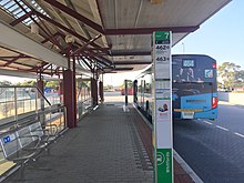
The bus interchange has eight bus stands with 19 regular bus routes. Buses run to Joondalup railway station, Warwick railway station, Mirrabooka bus station, and Ellenbrook. Train replacement buses operate on route 904.[1]
| Stop | Route | Destination / description | Notes |
|---|---|---|---|
| Stand 1 | 467 | to Joondalup station via Pearsall, Hocking & Ashby[21] | |
| 468 | to Joondalup station via Wanneroo Road[22] | ||
| Stand 2 | 355 | to Ellenbrook Central via Wangara, Gnangara Road & Henley Brook bus station[23] | |
| 374 | to Mirrabooka bus station via Madeley & Girrawheen Avenue[24] | ||
| 376 | to Mirrabooka bus station via Gnangara Road & Mirrabooka Avenue[25] | ||
| Stand 3 | 445 | to Warwick station via Coolibah Drive[26] | |
| 446 | to Warwick station via Allenswood Road[27] | ||
| 447 | to Warwick station via Moolanda Boulevard[28] | ||
| 904 | Rail replacement service to Butler station | ||
| Stand 4 | 443 | to Warwick station via Giles Avenue[29] | |
| 444 | to Warwick station via Gibson Avenue[30] | ||
| 904 | Rail replacement service to Perth station | ||
| Stand 5 | 441 | to Warwick station via Seacrest Drive[31] | |
| 442 | to Warwick station via Waterford Drive[32] | ||
| Stand 6 | 460 | to Joondalup station via Oceanside Promenade[33] | |
| 461 | to Joondalup station via Dampier Avenue[34] | ||
| Stand 7 | 462 | to Joondalup station via Bridgewater Drive[35] | |
| 463 | to Joondalup station via Gradient Way[36] | ||
| Stand 8 | 464 | to Joondalup station via Eddystone Avenue[37] | |
| 465 | to Joondalup station via Trappers Drive[38] | ||
| 466 | to Joondalup station via Timberlane Drive[39] |
References edit
- ^ a b "Whitfords Station – Access Map" (PDF). Transperth. Retrieved 12 October 2021.
- ^ a b "Manual – Rail Access" (PDF). Public Transport Authority. 30 August 2021. p. 11. Archived (PDF) from the original on 21 September 2021. Retrieved 20 September 2021.
- ^ a b c "Joondalup Line Train Timetable" (PDF). Transperth. Retrieved 13 October 2021.
- ^ a b c d Northern Suburbs Transit System; Perth to Joondalup Railway; Progress Summary – June 1991. Perth: The Urban Rail Electrification Committee, Government of Western Australia. 1991. pages 2, 20 Accessed at J S Battye Library, Perth
- ^ a b c Design Development; Northern Suburbs Transit System; Warwick Transfer Station for Perth Electric – Perth Urban Rail Development. Perth: Anthony Brand, Brand Dekyn and Hay – Architects. 1991.Accessed at Battye Library, Perth
- ^ a b History of Stations on the Clarkson Train Line Right Track
- ^ Bus/train interchanges on northern subs railway to open February Archived 10 January 2016 at the Wayback Machine Minister for Transport 28 January 1993
- ^ Transperth (21 March 1993). Bus Timetable – J11. Accessed at J S Battye Library, Perth
- ^ "Currambine to Butler Railway Extension – Clarkson Interim Master Plan – Stations" (PDF). New MetroRail. p. 2. Archived from the original (PDF) on 29 August 2007. Retrieved 24 October 2021.
- ^ "Landgate Map Viewer Plus". Landgate. Retrieved 24 October 2021. Zoom into Whitfords station. Compare 22/10/2002 with 09/02/2002.
- ^ "Work starts on expanding train station car parks". Media Statements. 27 October 2009. Archived from the original on 24 October 2021. Retrieved 24 October 2021.
- ^ "New car parking bays open at Whitfords". Media Statements. 20 April 2010. Archived from the original on 24 October 2021. Retrieved 24 October 2021.
- ^ "OnTrack: October 2003" (PDF). New MetroRail. October 2003. Archived from the original (PDF) on 29 August 2007. Retrieved 24 October 2021.
- ^ "OnTrack: April 2004" (PDF). New MetroRail. April 2004. Archived from the original (PDF) on 29 August 2007. Retrieved 24 October 2021.
- ^ "OnTrack: July 2004" (PDF). New MetroRail. July 2004. Archived from the original (PDF) on 29 August 2007. Retrieved 24 October 2021.
- ^ "Manual – Rail Access" (PDF). Public Transport Authority. 19 August 2022. Archived (PDF) from the original on 1 September 2022. Retrieved 10 September 2022.
- ^ "Question On Notice No. 4246 asked in the Legislative Assembly on 25 June 2015 by Mr M. Mcgowan". Parliament of Western Australia. 11 August 2015. Retrieved 12 October 2021.
- ^ "Yanchep Rail Extension Project Definition Plan" (PDF). Metronet. June 2018. p. 18. Retrieved 14 May 2023.
- ^ Farrell, Michael. "SmartRider". Metrodroid Wiki. GitHub. Archived from the original on 12 November 2020. Retrieved 3 August 2022.
- ^ "Stops Near You (99851)". Transperth. Government of Western Australia. Archived from the original on 8 August 2022. Retrieved 8 August 2022.
- ^ "Route 467". Bus Timetable 73 (PDF). Transperth. 6 March 2024 [effective from 16 April 2024].
- ^ "Route 468". Bus Timetable 73 (PDF). Transperth. 6 March 2024 [effective from 16 April 2024].
- ^ "Route 355". Bus Timetable 98 (PDF). Transperth. 26 April 2023 [effective from 12 June 2023].
- ^ "Route 374". Bus Timetable 74 (PDF). Transperth. 25 October 2023 [effective from 17 December 2023].
- ^ "Route 376". Bus Timetable 75 (PDF). Transperth. 13 November 2023 [effective from 17 December 2023].
- ^ "Route 445". Bus Timetable 64 (PDF). Transperth. 6 March 2024 [effective from 14 April 2024].
- ^ "Route 446". Bus Timetable 64 (PDF). Transperth. 6 March 2024 [effective from 14 April 2024].
- ^ "Route 447". Bus Timetable 64 (PDF). Transperth. 6 March 2024 [effective from 14 April 2024].
- ^ "Route 443". Bus Timetable 84 (PDF). Transperth. 24 October 2023 [effective from 17 December 2023].
- ^ "Route 444". Bus Timetable 84 (PDF). Transperth. 24 October 2023 [effective from 17 December 2023].
- ^ "Route 441". Bus Timetable 63 (PDF). Transperth. 11 January 2024 [effective from 28 January 2024].
- ^ "Route 442". Bus Timetable 63 (PDF). Transperth. 11 January 2024 [effective from 28 January 2024].
- ^ "Route 460". Bus Timetable 65 (PDF). Transperth. 11 January 2024 [effective from 28 January 2024].
- ^ "Route 461". Bus Timetable 65 (PDF). Transperth. 11 January 2024 [effective from 28 January 2024].
- ^ "Route 462". Bus Timetable 65 (PDF). Transperth. 11 January 2024 [effective from 28 January 2024].
- ^ "Route 463". Bus Timetable 66 (PDF). Transperth. 24 October 2023 [effective from 17 December 2023].
- ^ "Route 464". Bus Timetable 66 (PDF). Transperth. 24 October 2023 [effective from 17 December 2023].
- ^ "Route 465". Bus Timetable 66 (PDF). Transperth. 24 October 2023 [effective from 17 December 2023].
- ^ "Route 466". Bus Timetable 66 (PDF). Transperth. 24 October 2023 [effective from 17 December 2023].
External links edit
![]() Media related to Whitfords railway station at Wikimedia Commons
Media related to Whitfords railway station at Wikimedia Commons