


Summary
The Whittier Fire was a wildfire in the Santa Ynez Mountains, south of Lake Cachuma, along Highway 154 in Santa Barbara County, California in the United States. The fire was reported on July 8, 2017, at 1:43 pm.[2] Upon containment on July 28, the fire had burned a total of 18,430 acres (75 km2) and destroyed 16 homes.[1]
| Whittier Fire | |
|---|---|
 Whittier Fire on July 16, 2017 | |
| Date(s) |
|
| Location | Los Padres National Forest, Santa Barbara County, California |
| Coordinates | 34°34′01″N 119°57′11″W / 34.567°N 119.953°W |
| Statistics[1] | |
| Burned area | 18,430 acres (75 km2) |
| Impacts | |
| Non-fatal injuries | 9 |
| Ignition | |
| Cause | Under investigation |
| Map | |
 Location in Southern California | |
Events edit

The fire, which was first reported at 1:45 p.m. on Saturday, July 7, began burning in the Los Padres National Forest in chaparral that hadn't burned in approximately 70 years, according to officials.[1][3] Reportedly ignited by a vehicle fire, flames jumped Highway 154 and proceed in a southeast direction towards the Santa Ynez Mountains. Eighty people, including mostly children, at Circle V Ranch Camp near Lake Cachuma were forced to shelter in place as when it became too late to evacuate. No campers or staff were injured.[3] Throughout the course of the day, the fire had expanded from 330 to over 5,400 acres (22 km2) as containment sat at zero-percent.[4] Firefighters set up a command center at Dos Pueblos High School.[5]
On the morning of July 9, the fire had burned 7,800 acres and was at 5% containment. Residents along Farren Road inside and west of Goleta were evacuated.[6] 20 structures were destroyed, and a lot of evacuation was done along Highway 154.[7]
In the afternoon on July 9, the fire burned down the Rancho Alegre Outdoor School.[8] The fire remained "completely out of control", and sections of Highway 101 received evacuation warnings.[9] Later that day, it was reported that over 3,600 people had evacuated as a result of the Whittier Fire.[10]
On the morning of July 10, the fire had burned 10,823 acres and was still at 5% containment.[11]
On the morning of July 12, the fire had burned 11,920 acres and was at 48% containment.[12]
As of the evening of July 14, the fire was at 52% containment and had burned 13,199 acres. Due to changing weather conditions, the fire spread westward.[13]
On July 15, containment had dropped to 35% as the fire was pushed down the mountainside toward Goleta due to sundowner winds. It had burned 17,364 acres.[14]
On July 17, containment was at 49% and the fire had burned 18,311 acres.[15]
As of September 12, the fire is still not fully contained. It is stuck at 87% containment due to possible hot spots and reports of smoke.[16]
The fire was finally contained on October 5. Infrared survey 3 days prior to containment revealed some lingering heat sources, but they are located inside the containment line so the risk of further spread is minimal.[17]
In total, 16 homes and 30 outbuildings were destroyed. One home and six outbuildings were damaged.[1]
Gallery edit
-
 Smoke from the fire covers the sky over Goleta on July 8, 2017.
 -
 A helicopter leaving the Whittier Fire, July 11, 2017.
 -
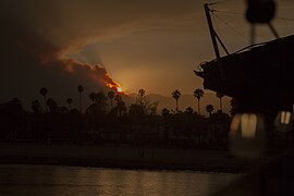 Smoke cloud seen from Stearns Wharf in Santa Barbara, July 14, 2017.
 -
 An area the Whittier Fire had burned, July 17, 2017.


References edit
- ^ a b c d "Whittier Fire". InciWeb. Archived from the original on July 14, 2017. Retrieved September 4, 2017.
- ^ "Whittier Fire". Incident Information. Cal Fire. Retrieved 4 September 2017.
- ^ a b Hesel, Phil. "Whittier, Alamo Fires Prompt Evacuations Amid California Heat Wave". NBC News. Retrieved 8 July 2017.
- ^ "Brush fire near Lake Cachuma prompts evacuations, closes Highway 154". ABC 7 Eyewitness News. Retrieved 8 July 2017.
- ^ "Dos Pueblos High School serving as Command Center for Whittier firefight - KEYT". www.keyt.com. Archived from the original on 2017-07-10.
- ^ "Whittier Fire burns 7,800 acres. Continued updates and information". NewsChannel 3. Retrieved 9 July 2017.
- ^ Gabbert, Bill (9 July 2017). "Whittier fire burns structures and forces evacuations northwest of Goleta, CA". Wildfire Today. Retrieved 9 July 2017.
- ^ Molina, Joshua (9 July 2017). "Whittier Fire Destroys Rancho Alegre Outdoor School, Boy Scouts Camp Home". Noozhawk. Retrieved 9 July 2017.
- ^ Bolton, Tom. "Whittier Fire still 'out of control,' grows to more than 7,800 acres". San Luis Obispo Tribune. Retrieved 9 July 2017.
- ^ "3,600 People..." Twitter. Retrieved 9 July 2017.
- ^ Schlepp, Travis; Flores, Oscar. "Whittier Fire burns 10,823 acres. Continued updates and information". NewsChannel 3. Retrieved 10 July 2017.
- ^ Bolton, Tom. "Flare-up on Northeast Side of Whittier Fire Puts Up Lots of Smoke over Santa Barbara". Noozhawk. Retrieved 12 July 2017.
- ^ Hodgson, Mike. "Update: Whittier firefighting resources increased with Sundowner winds expected". Santa Ynez Valley News. Retrieved 15 July 2017.
- ^ Bolton, Tom. "Whittier Fire Puts on Menacing Show as Sundowner Winds Whip Flames". Noozhawk. Retrieved 15 July 2017.
- ^ "Whittier Fire Remains at 87% Containment | Edhat". www.edhat.com. Retrieved Mar 13, 2020.
- ^ Bolton, Tom. "Weeks After Suppression Efforts Ended, Full Containment Still Not Declared for Whittier Fire". Noozhawk. Retrieved 29 September 2017.
- ^ Bolton, Tom. "After 3 months, Whittier Fire near Lake Cachuma is finally contained". San Louis Obispo Tribune. Retrieved 11 October 2017.