


Summary
Winsford is a village and civil parish in Somerset, England, located about 5 miles (8 km) north-west of Dulverton.
| Winsford | |
|---|---|
 | |
 Winsford Location within Somerset | |
| Population | 321 (2011)[1] |
| OS grid reference | SS905345 |
| District | |
| Shire county | |
| Region | |
| Country | England |
| Sovereign state | United Kingdom |
| Post town | Minehead |
| Postcode district | TA24 |
| Dialling code | 01643 |
| Police | Avon and Somerset |
| Fire | Devon and Somerset |
| Ambulance | South Western |
| UK Parliament | |
It is within the borders of the Exmoor National Park and around 10 miles (16.1 km) south-west of the coastal town of Minehead. The village has one hotel, The Royal Oak[2][3] dating to before the start of the 16th century, and one shop and post office. There is also a tea garden and a service station, which does not serve fuel for motor vehicles.
The village is on the route of the Samaritans Way South West and is located within the Exmoor National Park, to the east of the village is the hamlet of West Howetown.
History edit
Winsford Hill is the location of the Wambarrows, a number of Bronze Age burial sites, and Road Castle an Iron Age bank and ditch approximately 2 miles (3.2 km) west from the village. The ditch is almost square in plan with rounded corners and covers an area of approximately 0.7 acres (0.28 ha).[4]
The area is home to the Caratacus Stone, a standing stone believed to have been erected by pagan inhabitants of the village,[5] possibly as a religious memorial, bearing the inscription CARAACI NEPUS (kinsman of Caratacus) possibly from the 5th century,[6] and first documented in 1219.
The village appears in the Domesday Book of 1085, which lists the presence of 34 smallholders, 41 villagers, 52 sheep and 9 slaves, the whole area being capable of supporting 64 ploughs, despite 40 acres (160,000 m2) of it being woodland.[5] The parish of Winsford was part of the Williton and Freemanners Hundred.[7]
Farms in the village include Nethercote, Staddon, Bradley, Halse, Upcott and Knaplock, all of which have retained their original names since tax records from 1327, during the reign of King Edward III.[5]
In the 17th century, Tom Faggus, a highwayman and a gentleman, was said to have held up travellers near the inn in Winsford.[8]
On 20 August 1907 the first registered sale and show of the Exmoor Horn Sheep Breeders' Society, which was founded a year earlier, was held in the village, and "1,200 ewes were sold by auction, at an average price per head of 42 shillings".[9]
In 1998 the Exmoor Community Computer Centre is a charitable trust took over the redundant building of the Winsford First School and established a community facility for social welfare and recreation.[10] This later became dormant and a grant was obtained for a community facilitator to help restart the centre and re-establishing the venue as a community resource. Computer courses have also been run at Porlock and Sampford Brett.[11]
In 2002 the body of an apparent murder victim was found on Winsford Hill. Despite extensive investigations it has yet to be identified.[12]
Governance edit
The parish council has responsibility for local issues, including setting an annual precept (local rate) to cover the council's operating costs and producing annual accounts for public scrutiny. The parish council evaluates local planning applications and works with the local police, district council officers, and neighbourhood watch groups on matters of crime, security, and traffic. The parish council's role also includes initiating projects for the maintenance and repair of parish facilities, as well as consulting with the district council on the maintenance, repair, and improvement of highways, drainage, footpaths, public transport, and street cleaning. Conservation matters (including trees and listed buildings) and environmental issues are also the responsibility of the council.
The village falls within the non-metropolitan district of Somerset West and Taunton, which was established on 1 April 2019. It was previously in the district of West Somerset, which was formed on 1 April 1974 under the Local Government Act 1972, and part of Dulverton Rural District before that.[13] The district council is responsible for local planning and building control, local roads, council housing, environmental health, markets and fairs, refuse collection and recycling, cemeteries and crematoria, leisure services, parks, and tourism.
Somerset County Council is responsible for running the largest and most expensive local services such as education, social services, libraries, main roads, public transport, policing and fire services, trading standards, waste disposal and strategic planning.
It is also part of the Bridgwater and West Somerset constituency represented in the House of Commons of the Parliament of the United Kingdom. It elects one Member of Parliament (MP) by the first past the post system of election, and was part of the South West England constituency of the European Parliament which elected seven MEPs using the d'Hondt method of party-list proportional representation.
Geography edit

The name comes from the ford across the Winn Brook, where it meets the River Exe. There are eight bridges, providing crossing points over the many small streams that run through the village; one is a packhorse bridge,[14][15][16][17][18] which is thought to be several hundred years old.[5] The Vicarage Bridge is 42 inches (1,100 mm) wide and 30 feet (9.1 m) long.[19]
Winsford Common is situated in a hollow in the surrounding countryside (which itself is within a valley), somewhat akin in shape to that of a punch bowl, and thus has gained the name of The Punchbowl. Given the shape and orientation of this deep hollow on the northeastern edge of the extensive plateau of Winsford Hill and the nature of some of the deposits within it, it has been suggested that it was the site of what may have been the only glacier on Exmoor and indeed in southwest England during the Pleistocene ice ages.[20] It was a meeting point for the Tiverton hounds and Dulverton harriers.[21]
The subsoil of Winsford consists of rock shillet, whereas the topsoil has more of a clay-like and loamy character. Iron ore can be found in the mineral deposits of the village, and the mining of this was formerly important to Winsford's economy.[21] Garratts Wood covers a total area of 1.11 hectares (2.74 acres). It is owned and managed by the Woodland Trust.[22]
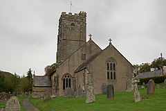
Church edit
The parish church is dedicated to St Mary Magdalene and was partly restored in 1858. The tower, which is 90 feet (27.4 m) high,[23] was constructed in three stages. There are six bells; the four heaviest were made by Thomas Bilbie in Cullompton in 1765.[24]
Within the church is a fine painted panel created in 1609 during the reign of King James I.[25] The ironwork on the inner doors of the church is thought to date from the 13th century, originating from the priory of St Nicholas in Barlynch, and the font is from the Norman period. The organ was installed c. 1900, being delivered by horse-drawn wagon from nearby Dulverton.[5] The church register dates back to 1660.[21] The church has been designated by English Heritage as a Grade I listed building.[26]
Famous inhabitants edit
In 1881 the village was the birthplace of the Labour politician and Lord Privy Seal, Ernest Bevin.[6][27]
In 1946 leading English psychologist Charles Samuel Myers died at his home in Winsford Glebe.
References edit
- ^ "Statistics for Wards, LSOAs and Parishes — SUMMARY Profiles" (Excel). Somerset Intelligence. Retrieved 4 January 2014.
- ^ Historic England. "Karslake House (1295888)". National Heritage List for England. Retrieved 3 October 2007.
- ^ Historic England. "The Royal Oak Inn (1295855)". National Heritage List for England. Retrieved 3 October 2007.
- ^ Historic England. "Road Castle (35715)". Research records (formerly PastScape). Retrieved 12 May 2011.
- ^ a b c d e "Winsford". Everything Exmoor. Retrieved 3 October 2007.
- ^ a b Bush, Robin (1994). Somerset: The complete guide. Wimborne, Dorset: Dovecote Press. ISBN 1-874336-27-X.
- ^ "Somerset Hundreds". GENUKI. Retrieved 23 October 2011.
- ^ "Exmoor National Park". Equinetourism. Archived from the original on 30 November 2007. Retrieved 6 July 2009.
- ^ "History of the breed". Exmoor Horn Sheep Breeders’ Society. Retrieved 3 October 2007.
- ^ "Exmoor Community Computer Centre". Exmoor Community Computer Centre. Archived from the original on 18 April 2010. Retrieved 14 May 2010.
- ^ "Exmoor Computer Centre — Winsford". Somerset Rural Renaissance. Retrieved 14 May 2010.
- ^ Alder, Chris (17 September 2006). "Mystery body to be laid to rest". somersetcountygazette.co.uk. Somerset County Gazette. Retrieved 13 October 2011.
- ^ "Dulverton RD". A vision of Britain Through Time. University of Portsmouth. Retrieved 5 January 2014.
- ^ Historic England. "Edbrooke Bridge (1295874)". National Heritage List for England. Retrieved 3 October 2007.
- ^ Historic England. "Packhorse bridge (1174159)". National Heritage List for England. Retrieved 3 October 2007.
- ^ Historic England. "Packhorse bridge (1345401)". National Heritage List for England. Retrieved 3 October 2007.
- ^ Historic England. "Packhorse bridge (1174193)". National Heritage List for England. Retrieved 3 October 2007.
- ^ Historic England. "Vicarage Bridge (1174205)". National Heritage List for England. Retrieved 3 October 2007.
- ^ Hinchliffe, Ernest (1994). Guide to the Packhorse Bridges of England. Cicerone. pp. 153–154. ISBN 978-1852841430.
- ^ Harrison,S. and Keen, D.H. in Lewis, C.A. and Richards, A.E. 2005 The glaciations of Wales and adjacent areas Logaston Press, Bristol
- ^ a b c "Winsford". GENUKI. Retrieved 3 October 2007.
- ^ "Garratts Wood - a Woodland Trust Wood". Woodland Trust. Retrieved 2 August 2012.
- ^ Leete-Hodge, Lornie (1985). Curiosities of Somerset. Bodmin: Bossiney Books. pp. 61–63. ISBN 0-906456-98-3.
- ^ Moore, James; Rice, Roy; Hucker, Ernest (1995). Bilbie and the Chew Valley clock makers. The authors. ISBN 0-9526702-0-8.
- ^ "Winsford". Everything Exmoor. Retrieved 12 November 2010.
- ^ Historic England. "Church of St Mary Magdalene (1174169)". National Heritage List for England. Retrieved 3 October 2007.
- ^ Historic England. "Bevins House (1345400)". National Heritage List for England. Retrieved 3 October 2007.
External links edit
![]() Media related to Winsford, Somerset at Wikimedia Commons
Media related to Winsford, Somerset at Wikimedia Commons