
KNOWPIA
WELCOME TO KNOWPIA

Witteveen, Midden-Drenthe 
Summary
Witteveen (Dutch pronunciation: [ˈʋɪtəˌveːn]; English: White Bog) is a village in the Dutch province of Drenthe. It is a part of the municipality of Midden-Drenthe, and lies about 16 km northeast of Hoogeveen.
Witteveen | |
|---|---|
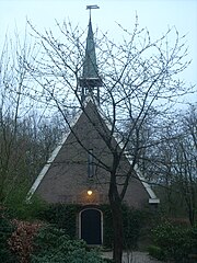 Former chapel of Witteveen | |
 Flag | |
 Witteveen Location in the province of Drenthe in the Netherlands  Witteveen Witteveen (Netherlands) | |
| Coordinates: 52°48′51″N 6°39′36″E / 52.81417°N 6.66000°E | |
| Country | Netherlands |
| Province | Drenthe |
| Municipality | Midden-Drenthe |
| Established | 1926 |
| Area | |
| • Total | 15.72 km2 (6.07 sq mi) |
| Elevation | 17 m (56 ft) |
| Population (2021)[1] | |
| • Total | 555 |
| • Density | 35/km2 (91/sq mi) |
| Time zone | UTC+1 (CET) |
| • Summer (DST) | UTC+2 (CEST) |
| Postal code | 9439[1] |
| Dialing code | 0593 |
The village was first mentioned in 1856 as "het Witteveen", and means "white peat". In 1926, the peat was excavated as part of a project for the unemployed.[3] 50 houses were built to house the workers. In 1929, a small Dutch Reformed church was built.[4] The church is nowadays used as a residential home.[5]
Gallery edit
-
 Former clergy house
 -
 Welcome to Witteveen


References edit
- ^ a b c "Kerncijfers wijken en buurten 2021". Central Bureau of Statistics. Retrieved 11 April 2022.
- ^ "Postcodetool for 9439PA". Actueel Hoogtebestand Nederland (in Dutch). Het Waterschapshuis. Retrieved 11 April 2022.
- ^ "Witteveen - (geografische naam)". Eymologiebank (in Dutch). Retrieved 11 April 2022.
- ^ Ronald Stenvert (2001). Witteveen (in Dutch). Zwolle: Waanders. p. 61. ISBN 90 400 9454 3. Retrieved 11 April 2022.
- ^ "Witteveen". Plaatsengids (in Dutch). Retrieved 11 April 2022.
External links edit
 Media related to Witteveen, Midden-Drenthe at Wikimedia Commons