


Summary
The Wittmoor bog trackway is the name given to each of two historic corduroy roads, trackway No. I being discovered in 1898 and trackway No. II in 1904[1] in the Wittmoor bog in northern Hamburg, Germany. The trackways date to the 4th and 7th century AD, both linked the eastern and western shores of the formerly inaccessible, swampy bog. A part of the older trackway No. II dating to the period of the Roman Empire is on display at the permanent exhibition of the Archaeological Museum Hamburg in Harburg, Hamburg.[2][3]

Location edit

Both bog trackways are located in the Wittmoor bog in the Hamburg districts of Duvenstedt, Lemsahl-Mellingstedt and the Norderstedt district of Glashütte in Schleswig-Holstein. Both trackways have been disturbed by historical peat cutters. In 1898 Ludwig Frahm, a local school teacher and historian followed a hint from Hinrich Mohr, a carpenter from Poppenbüttel, showing him the location of what he called a Russian causeway which is actually trackway No. I.[4][5] In 1900 Frahm excavated a few planks of the trackway, publishing his findings in 1901 and 1913. The two bog trackways found in Wittmoor were excellently preserved due to the moist, peaty soil.[6]
Bog trackway No. I edit

Bog trackway I (location: 53°42′10″N 10°04′18″E / 53.702829°N 10.0717169°E[6]) was discovered in 1898, in 1900 and 1901 Frahm excavated a part of the trackway together with Prof. Wilms[4] and it was re-examined by the archaeologists Prejawa and Kolumbe in the 1930s. The trackway ran in southeasterly direction through the Wittmoor and had a length of about 500 metres (1,600 ft). Even during World War II most of the western part of the pead bog were cut for fuel production which destroyed large sections of the trackway. This bog trackway was built up in a much easier technique than the older bog trackway II The path consisted of clean-hewn oak planks ranging from 180 centimetres (71 in) to 200 centimetres (79 in) in length and 20 centimetres (7.9 in) to 30 centimetres (12 in) width laid directly on the surface of the bog. The trackway was embedded in the peat in a depth of only 1 metre (3.3 ft) from below the surface. Also in this part of the bog peat was regularly taken for fuel production, which gradually destroyed the trackway. The well-preserved wooden planks of the way were taken by the peat cutters and used as firewood.[6]
Bog trackway No. II edit
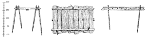
Bog trackway No. II (location: 53°42′00″N 10°04′10″E / 53.699984°N 10.069399°E[6]) was discovered in 1904 by Hamburg state geologist Dr. Wolff. It too runs in a southeasterly direction through the Wittmoor, and had a length of about 600 metres (2,000 ft) and was located parallel to and c. 500 metres (1,600 ft) south-southwest of trackway No. I. This path was gradually destroyed through regular peat cutting. In 1947 approximately 2 metres (6.6 ft) of the central part was excavated by Kellermann in 1947 which is now on displayed in the permanent collection of the Archaeological Museum in Hamburg. The substructure of the road consisted of two split oak planks that were placed parallel to each other on a sand or gravel foundation on the formerly swampy terrain. The thresholds were piles of split oak boards ranging from about 130 centimetres (51 in) to 160 centimetres (63 in) in length, widths between 25 centimetres (9.8 in) and 45 centimetres (18 in) and thickness of 2 centimetres (0.79 in) to 6 centimetres (2.4 in) laid transverse to the direction of the path. The thresholds were notched so as to prevent slipping on the boards. Every second threshold was cut diagonally at the ends. Through the gaps birch poles were driven into the ground to prevent slipping of the thresholds. A large part of the excavated path resembled a building site, the woods were torn out of the path way and thrown together in one place. Beside it newly trimmed timbers were found which were designed to be built in the new way, as well as items interpreted as tools, like a crowbar and mallet. Charred small pieces of wood indicating a fireplace.[6] In 1938 the bog trackway was initially dated by pollen analysis to the 6th century BC;[7] however, a radiocarbon dating performed in 1957 yielded an age nearer the beginning of the Christian era.[8] The most recent dendrochronological dating performed in 1996 yielded a felling date of the trees around the 330 AD[3][9]
-
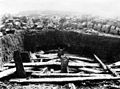 Excavation situation in the 1930s
 -
 Detail of the pile displacement II in the 1930s
 -
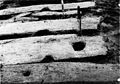 Mortise in a threshold in the 1930s


Interpretation edit
The discovery of the two bog trackways disproved the old doctrine that such bog trackways only occurred south of the river Elbe.[5] They show that in earlier times, a lively exchange between the western and eastern shores of the marshland occurred, and that the routes were considered so important that a significant logistical and substantive effort was expended to build paths through the marsh rather than circumvent the area. No archaeological evidence for settlements have been detected belonging to the bog trackways.[10]
References edit
- ^ The numbering of the trackways No. I for the younger northern one and No. II for the older southern one follows the local archive file of Archaeological Museum of Hamburg corresponding to early publications, in contrast to that Schindler uses a different numbering in his publication.
- ^ Topic Mobility, Show case no. 80.
- ^ a b Articus, Rüdiger; Brandt, Jochen; Först, Elke; Krause, Yvonne; Merkel, Michael; Mertens, Kathrin; Weiss, Rainer-Maria (2013). Archaeological Museum Hamburg Helms-Museum: A short guide to the Tour of the Times. Archaeological Museum Hamburg publication - Helms-Museum. Vol. 103. Hamburg. p. 108. ISBN 978-3-931429-24-9.
{{cite book}}: CS1 maint: location missing publisher (link) - ^ a b Frahm, Ludwig (1930). "Wie wir den ersten Bohlenweg auf dem Wittmoor fanden". Jahrbuch des Alstervereins: 30 Jahre Alster-Verein (in German). 18. Hamburg-Wandsbek: Christiansen: 26–29.
- ^ a b Ziesche, Ferdinand (November 2006). "Der Forscherdrang des Ludwig Frahm - Entdeckung im Wittmoor" (PDF). Alstertal-Magazin (in German): 118–119. Retrieved 2012-09-19.
- ^ a b c d e Schindler, Reinhard (1960), Die Bodenaltertümer der Freien und Hansestadt Hamburg (in German), Hamburg: Hans Christians, pp. 119–121, Annex 1
- ^ Preiawa, H. (1901). "Die Bohlenwege im Wittmoor". Mitteilungen des Anthropologischen Vereins in Schleswig-Holstein (in German). 19. Kiel: Lipsius & Tische: 57–67. ISSN 0179-9703.
- ^ Averdieck, R.; Münnich (1957). "Palynologische Betrachtungen zur Siedlungsgeschichte im Norden Hamburgs unter Zuhilfenahme neuerer Datierungsmethoden". Hammaburg N.F. (in German). 5: 9. ISSN 0173-0886.
- ^ Thieme, Wulf. H. Linde-Lebke (ed.). "Alte Wege über das Moor". Von der einstigen Tangstdter Heide zum heutigen Norderstedter Stadtteil Glashütte, 100 Jahre 1896-1996 (in German): 23–25.
- ^ Thieme, Wulf (2011). Jürgen Ehlers (ed.). "9. Ur- und Frühgeschichte" (PDF). Geologische Karte von Hamburg 1:25 000 - Erläuterungen zu Blatt Nr. 2326 Fuhlsbüttel (in German). Hamburg: Geologisches Landesamt: 100–102. Retrieved 2012-09-19.