
KNOWPIA
WELCOME TO KNOWPIA

Wood Island (Marin County) 
Summary
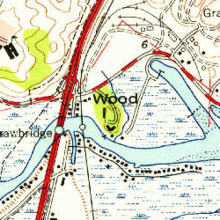
Wood Island is a former island in Marin County, California, formerly in the Corte Madera Creek (upstream of San Francisco Bay) but now surrounded by land. Its coordinates are 37°56′37″N 122°30′42″W / 37.94361°N 122.51167°W[1], and the United States Geological Survey measured its elevation as 13 ft (4.0 m) in 1981.[1] It appears in a 1954 USGS map of the region.[2] In the 1960s, its principal owner was Spero Spiliotis.[3] In 1969, the city of Larkspur passed a resolution of intent to annex the island,[4] and in the 1970s, a ferry terminal had been proposed.[5]
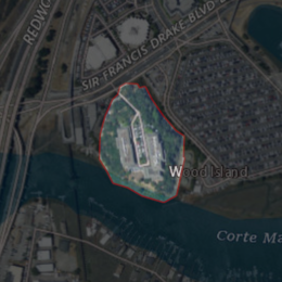 USGS aerial imagery of Wood Island | |
 Wood Island  Wood Island  Wood Island | |
| Geography | |
|---|---|
| Location | Northern California |
| Coordinates | 37°56′37″N 122°30′42″W / 37.94361°N 122.51167°W[1] |
| Adjacent to | Corte Madera Creek |
| Highest elevation | 13 ft (4 m)[1] |
| Administration | |
United States | |
| State | |
| County | Marin |
References edit
- ^ a b c d U.S. Geological Survey Geographic Names Information System: Wood Island
- ^ United States Geological Survey (1954). "San Rafael Quadrangle, California" (Map). United States Department of the Interior Geological Survey. 1:24000.
- ^ "Wood Island Area Value Is $88,375". Daily Independent Journal. San Rafael, California. 1967-06-23. p. 5.
- ^ "The Larkspur City Council Also". Daily Independent Journal. San Rafael, California. 1969-06-19. p. 18.
- ^ "Larkspur Argues Planning Report". Daily Independent Journal. San Rafael, California. 1972-03-22. p. 37.