


Summary
Wotans Throne is a 7,721-foot-elevation (2,353-meter) summit located in the Grand Canyon, in Coconino County, Arizona, US.[3] It is situated one mile immediately southwest of the Cape Royal overlook on the canyon's North Rim, 1.7 miles west-southwest of Freya Castle, two miles west-northwest of Vishnu Temple, and five miles east of Zoroaster Temple. It rises 5,200 feet (1,600 meters) above the Colorado River.
| Wotans Throne | |
|---|---|
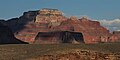
 Northeast aspect, from Cape Royal Overlook | |
| Highest point | |
| Elevation | 7,721 ft (2,353 m)[1] |
| Prominence | 596 ft (182 m)[1] |
| Parent peak | Siegfried Pyre (7,922 ft)[2] |
| Isolation | 7.04 mi (11.33 km)[2] |
| Coordinates | 36°06′17″N 111°57′37″W / 36.1048317°N 111.9602795°W[3] |
| Geography | |
 Wotans Throne  Wotans Throne | |
| Location | Grand Canyon Coconino County, Arizona, US |
| Parent range | Kaibab Plateau[1] Colorado Plateau |
| Topo map | USGS Cape Royal |
| Geology | |
| Type of rock | sandstone, limestone, shale |
Wotans Throne is named for Wotan, the supreme Germanic deity. This toponym was applied by geologist François E. Matthes, in keeping with Clarence Dutton's practice of naming geographical features in the Grand Canyon after mythological deities.[4] This geographical feature's name was officially adopted in 1906 by the U.S. Board on Geographic Names.[3] According to the Köppen climate classification system, Wotans Throne is located in a Cold semi-arid climate zone.[5]
Geology edit
The wooded top of Wotans Throne is composed of 700-feet-thick Kaibab Limestone overlaying 300-feet-thick, cream-colored, cliff-forming, Permian Coconino Sandstone.[6] The sandstone, which is the third-youngest of the strata in the Grand Canyon, was deposited 265 million years ago as sand dunes. Below the Coconino Sandstone is slope-forming, Permian Hermit Formation, which in turn overlays the Pennsylvanian-Permian Supai Group. Further down are strata of Mississippian Redwall Limestone, Cambrian Tonto Group, and finally Proterozoic Unkar Group at creek level.[6] Precipitation runoff from Wotans Throne drains south to the Colorado River via Vishnu Creek on its east side, and Clear Creek on the west side.
Gallery edit
-
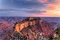 At sunset from Cape Royal
 -
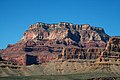 South aspect
 -
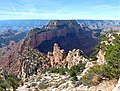
 Wotans Throne, with Angels Gate in front blending in
 -
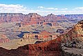 Wotans Throne left of center with Vishnu Temple to right, seen from South Rim
 -
 Wotans Throne (centered), from South Rim at sunset
 -
 From Cape Royal
 -
 Wotans Throne (left) and Angels Gate from west
 -
 From the south. Left to right: Angels Gate, Wotans Throne, Newberry Butte, and Vishnu Temple
 -


See also edit
References edit
- ^ a b c "Wotans Throne, Arizona". Peakbagger.com. Retrieved 2020-12-21.
- ^ a b "Wotans Throne – 7,740' AZ". Lists of John. Retrieved December 21, 2020.
- ^ a b c "Wotans Throne". Geographic Names Information System. United States Geological Survey, United States Department of the Interior. Retrieved 2020-12-21.
- ^ Stephen J. Pyne, Fire on the Rim, 1989, University of Washington Press, page 130.
- ^ Peel, M. C.; Finlayson, B. L.; McMahon, T. A. (2007). "Updated world map of the Köppen−Geiger climate classification". Hydrol. Earth Syst. Sci. 11. ISSN 1027-5606.
- ^ a b N.H. Darton, Story of the Grand Canyon of Arizona, 1917, page 46.
External links edit
- Weather forecast: National Weather Service
- Wotans Throne photo by Harvey Butchart