


Summary
Xueshan, formerly known as Mount Sylvia and by other names, is a mountain in the Heping District of Taichung, Taiwan. It is the 2nd-highest mountain in Taiwan and in East Asia, at 3,886 m (12,749 ft) above sea level. It is located in the Shei-Pa National Park and is visible in good weather from hills near Taiwan's capital Taipei.
| 雪山 | |
|---|---|
| Snow Mountain | |
 The summit as seen from the east peak | |
| Highest point | |
| Elevation | 3,886 m (12,749 ft)[1] |
| Prominence | 1,932 m (6,339 ft)[1] |
| Listing | Ultra 100 Peaks of Taiwan |
| Coordinates | 24°23′00″N 121°13′48″E / 24.38333°N 121.23000°E[1] |
| Geography | |
 雪山 The location of Xueshan (Shei-Pa National Park) | |
| Location | Heping District, Taichung/ Tai'an, Miaoli County, Taiwan |
| Parent range | Xueshan Range |
| Climbing | |
| Easiest route | Maintained trail, snow/ice climb during some winter months |
| Xueshan | |||||||||||||||
|---|---|---|---|---|---|---|---|---|---|---|---|---|---|---|---|
| Chinese | 雪山 | ||||||||||||||
| Literal meaning | Snowy Mountain | ||||||||||||||
| |||||||||||||||
| Former names | |||||||||
|---|---|---|---|---|---|---|---|---|---|
| Chinese | 三叉山 | ||||||||
| Literal meaning | 3-Prong Mountain | ||||||||
| |||||||||
| Tsugitakayama | |||||||
|---|---|---|---|---|---|---|---|
| Chinese name | |||||||
| Chinese | 次高山 | ||||||
| Literal meaning | Next-Highest Mountain | ||||||
| |||||||
| Japanese name | |||||||
| Kanji | 次高山 | ||||||
| |||||||
Names edit
Xuěshān is the pinyin romanization of the Chinese name 雪山, meaning "Snow" or "Snowy Mountain". The same name is romanized as Hsüehshan using the Wade-Giles system.
During the Qing Dynasty, the mountain was known to Westerners as Mount Sylvia.[2][3][4] It was also known as Shan-chas-shan[2] (properly, Sānchāshān) from a Chinese name meaning "3-Forked" or "3-Prong Mountain". During Japan's occupation of Taiwan, improved surveys showed that Xueshan was shorter than Yushan on Taiwan but taller than Mount Fuji in the Japanese Islands. Its name was accordingly changed to Tsugitakayama (次高山), meaning "Next-" or "Second-Highest Mountain", in 1923.
History edit
The mountain was first climbed in 1935 by Japanese climbers.[5]
The Japanese governor-general designated Xueshan part of the Tsugitaka-Taroko National Park by the Governor-General of Taiwan on 12 December 1937.
Climbing Xueshan edit
Xueshan is a part of the Shei-Pa National Park and so climbers are required to apply for a park entry permit. This can be done 5–60 days in advance. International hikers can apply for a park entry permit between 35 days and 4 months in advance. After that a police mountain entry permit must be applied for. This can be done at the police station in Wuling Farm on the spot.
There are two cabins on the trail. The first, Chika Cabin, is at the 2.0 kilometers (1.2 mi) mark. The second, 369 Cabin, is at the 6.9 kilometers (4.3 mi) mark. Both cabins are spartan, and contain bunker style beds. Hikers must bring their own sleeping and cooking gear.
The peak is at the 10.9 kilometers (6.8 mi) mark.[6]
Gallery edit
-
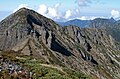
 Xueshan Main Peak
 -
 Shengleng Trail (Holy Ridge Trail)
 -
 Cirque or Landslide Valley #1
 -
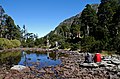 Cuei Pond


![[3]](#cite_note-FOOTNOTECampbell1896%5B%5B:c:File:1896_map_of_Taiwan.png%7Cmap%5D%5D-3)
![[4]](#cite_note-FOOTNOTEDavidson1903%5B%5B:c:File:Davidson_(1901)_-_General_Map_of_Formosa.jpg%7Cmap%5D%5D-4)
See also edit
References edit
Citations edit
- ^ a b c "Central and Eastern China, Taiwan and Korea" Peaklist.org. Retrieved 2011-11-24.
- ^ a b EB (1879), pp. 415–6.
- ^ Campbell (1896), map.
- ^ Davidson (1903), map.
- ^ Leon E. Seltzer, ed. (1952). "Sylvia, Mount". The Columbia Lippincott Gazetteer of the World. Morningside Heights, NY: Columbia University Press. p. 1856. OCLC 802473294.
- ^ "Mt. Xue Main Peak & East Peak Trail". Hikingbook Inc. Retrieved 2024-02-22.
_-_General_Map_of_Formosa.jpg%7Cmap%5D%5D_4-0)
Bibliography edit
- , Encyclopaedia Britannica, 9th ed., Vol. IX, New York: Charles Scribner's Sons, 1879, pp. 415–17.
- Campbell, William (1896). "The Island of Formosa: Its Past and Future". Scottish Geographical Magazine. 12 (8): 385–399. doi:10.1080/00369229608732903.
- Davidson, James W. (1903). The Island of Formosa, Past and Present: History, People, Resources, and Commercial Prospects: Tea, Camphor, Sugar, Gold, Coal, Sulphur, Economical Plants, and Other Productions. London and New York: Macmillan. OL 6931635M.