


Summary
Yagodninsky District (Russian: Я́годнинский райо́н) is an administrative[1] and municipal[6] district (raion), one of the eight in Magadan Oblast, Russia. It is located in the western central part of the oblast. The area of the district is 29,500 square kilometers (11,400 sq mi).[2] Its administrative center is the urban locality (an urban-type settlement) of Yagodnoye.[1] Population: 9,839 (2010 Census);[3] 15,833 (2002 Census);[8] 50,174 (1989 Census).[9] The population of Yagodnoye accounts for 42.8% of the district's total population.[3]
Yagodninsky District
Ягоднинский район | |
|---|---|
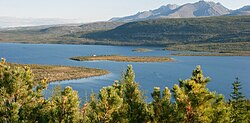 Jack London Lake, Yagodninsky District | |
 Flag  Coat of arms | |
 Location of Yagodninsky District in Magadan Oblast | |
| Coordinates: 62°40′N 151°20′E / 62.667°N 151.333°E | |
| Country | Russia |
| Federal subject | Magadan Oblast[1] |
| Established | 1953 |
| Administrative center | Yagodnoye[1] |
| Area | |
| • Total | 29,500 km2 (11,400 sq mi) |
| Population | |
| • Total | 9,839 |
| • Estimate (2018)[4] | 7,320 (−25.6%) |
| • Density | 0.33/km2 (0.86/sq mi) |
| • Urban | 97.2% |
| • Rural | 2.8% |
| Administrative structure | |
| • Inhabited localities[1] | 6 Urban-type settlements[5], 11 rural localities |
| Municipal structure | |
| • Municipally incorporated as | Yagodninsky Municipal District[6] |
| • Municipal divisions[6] | 5 urban settlements, 1 rural settlements |
| Time zone | UTC+11 (MSK+8 |
| OKTMO ID | 44722000 |
| Website | http://yagodnoeadm.ru/ |
Geography edit
The district borders with Susumansky District in the north, Srednekansky District in the east, Khasynsky District in the south, and with Tenkinsky District in the west. There are a number of abandoned villages in the district, such as Taskan, Elgen and Ust-Taskan.
The most important rivers of the district are the Kolyma, Debin, Orotukan, Taskan, Bakhapcha and Kongo.[10]
See also edit
References edit
Notes edit
- ^ a b c d e Law #1292-OZ
- ^ a b "General Information" (in Russian). Yagodninsky District. Retrieved May 15, 2017.
- ^ a b c Russian Federal State Statistics Service (2011). Всероссийская перепись населения 2010 года. Том 1 [2010 All-Russian Population Census, vol. 1]. Всероссийская перепись населения 2010 года [2010 All-Russia Population Census] (in Russian). Federal State Statistics Service.
- ^ "26. Численность постоянного населения Российской Федерации по муниципальным образованиям на 1 января 2018 года". Federal State Statistics Service. Retrieved January 23, 2019.
- ^ The count of urban-type settlements may include the work settlements, the resort settlements, the suburban (dacha) settlements, as well as urban-type settlements proper.
- ^ a b c Law #511-OZ
- ^ "Об исчислении времени". Официальный интернет-портал правовой информации (in Russian). June 3, 2011. Retrieved January 19, 2019.
- ^ Russian Federal State Statistics Service (May 21, 2004). Численность населения России, субъектов Российской Федерации в составе федеральных округов, районов, городских поселений, сельских населённых пунктов – районных центров и сельских населённых пунктов с населением 3 тысячи и более человек [Population of Russia, Its Federal Districts, Federal Subjects, Districts, Urban Localities, Rural Localities—Administrative Centers, and Rural Localities with Population of Over 3,000] (XLS). Всероссийская перепись населения 2002 года [All-Russia Population Census of 2002] (in Russian).
- ^ Всесоюзная перепись населения 1989 г. Численность наличного населения союзных и автономных республик, автономных областей и округов, краёв, областей, районов, городских поселений и сёл-райцентров [All Union Population Census of 1989: Present Population of Union and Autonomous Republics, Autonomous Oblasts and Okrugs, Krais, Oblasts, Districts, Urban Settlements, and Villages Serving as District Administrative Centers]. Всесоюзная перепись населения 1989 года [All-Union Population Census of 1989] (in Russian). Институт демографии Национального исследовательского университета: Высшая школа экономики [Institute of Demography at the National Research University: Higher School of Economics]. 1989 – via Demoscope Weekly.
- ^ Google Earth
Sources edit
- Магаданская областная Дума. Закон №1292-ОЗ от 9 июня 2010 г. «Об административно-территориальном устройстве Магаданской области», в ред. Закона №1756-ОЗ от 9 июня 2014 г. «О внесении изменений в Закон Магаданской области "Об административно-территориальном устройстве Магаданской области"». Вступил в силу через 10 дней после дня официального опубликования. Опубликован: Приложение к газете "Магаданская правда", №63(20183), 16 июня 2010 г. (Magadan Oblast Duma. Law #1292-OZ of June 9, 2010 On the Administrative-Territorial Structure of Magadan Oblast, as amended by the Law #1756-OZ of June 9, 2014 On Amending the Law of Magadan Oblast "On the Administrative-Territorial Structure of Magadan Oblast". Effective as of the day which is 10 days after the official publication date.).
- Магаданская областная Дума. Закон №511-ОЗ от 28 декабря 2004 г. «О границах и статусе муниципальных образований в Магаданской области», в ред. Закона №1887-ОЗ от 8 апреля 2015 г. «О преобразовании муниципальных образований "посёлок Усть-Омчуг", "посёлок Омчак", "посёлок им. Гастелло", "посёлок Мадаун" путём их объединения с наделением статуса городского округа». Вступил в силу с 31 декабря 2004 г., за исключением положений, для которых установлены иные сроки вступления в силу. Опубликован: "Магаданская правда", №146 (19370), 29 декабря 2004 г. (Magadan Oblast Duma. Law #511-OZ of December 28, 2004 On the Borders and Status of the Municipal Formations in Magadan Oblast, as amended by the Law #1887-OZ of April 8, 2015 On the Transformation of the Municipal Formations of the "Settlement of Ust-Omchug", "Settlement of Omchak", "Settlement of imeni Gastello", "Settlement of Madaun" by Merging Them and Giving Them a Status of the Urban Okrug. Effective as of December 31, 2004, with the exception of clauses for which different dates of taking effect have been set.).