


Summary
Yanmen Commandery was an administrative subdivision (jùn) of the state of Zhao established c. 300 BC and of northern imperial Chinese dynasties until AD 758. It occupied lands in what is now Shanxi and Inner Mongolia. Its first seat was at Shanwu (near present-day Youyu, Shanxi); its later seats moved southeast to the more defensible sites at Yinguan (within present-day Shuozhou, Shanxi) and Guangwu (near present-day Daixian, Shanxi).
| Yanmen Commandery | |||||||||
|---|---|---|---|---|---|---|---|---|---|
| Traditional Chinese | 雁門郡 鴈門郡 | ||||||||
| Simplified Chinese | 雁门郡 | ||||||||
| Literal meaning | Wild Goose Gate Commandery | ||||||||
| |||||||||
Name edit
The name derives from Yanmen Pass in Shanxi's Dai County. Yanmen, meaning "Wild Goose Pass"[1] or "Wildgoose Gate",[2] takes its name from the wild geese that migrate through the area.[3]
History edit
Zhao Kingdom edit

Yanmen Commandery was first established around 300 BC during China's Warring States Period by the state of Zhao's King Yong, posthumously known as the Wuling ("Martial-&-Numinous") King.[4] It covered territory in what is now northern Shanxi and southern Inner Mongolia.[5] He created Yanmen Commandery along with its companion commanderies of Dai and Yunzhong to consolidate his conquests[4] from invasions of the Loufan (t 樓煩, s 楼烦, Lóufán) and "forest nomads" or "barbarians"[6][7] (林胡, Línhú) in 306 and 304 BC.[8] He protected these new lands by raising earthen walls along their northern border,[4][9] close to what is now Hohhot in Inner Mongolia.[10][11] Garrisons and forts were also placed at strategic spots within the new territory, such as Yanmen Pass[3] between the northern plains and the Hutuo Valley. In the mid-3rd century BC, the Yanmen governor Li Mu, relocated there under the command of Handan used these interior defenses and drills the commandery's citizens to minimize casualties to good effect when he lured more than 100,000 Xiongnu horsemen into the heart of the commandery before defeating them with 160,000 chariots, cavalry, and archers.[12]
Qin Empire edit
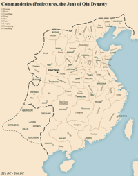
Under the Qin, Yanmen was one of the commanderies which made up the principal divisions of the empire.[13] Its seat was at Shanwu, south of present-day Youyu in Shanxi.[5][14] Its territory ran from present-day Shanxi's Hequ, Wuzhai, and Ningwu Counties in the south to Inner Mongolia's Huangqi and Dai Lakes in the north; its eastern border was near Mount Heng.[14] The Zhao wall was connected to those of the other former states as part of the Great Wall.[12] This territory was divided into:[13]
| Qin-era Counties | |||
|---|---|---|---|
| English | Chinese | ||
| Trad. | Simp. | Pinyin | |
| Shanwu | 善無縣 | 善无县 | Shànwú Xiàn |
| Pingcheng | 平城縣 | 平城县 | Píngchéng Xiàn |
| Mayi | 馬邑縣 | 马邑县 | Mǎyì Xiàn |
| Xincheng | 新城縣 | 新城县 | Xīnchéng Xiàn |
| Loufan | 樓煩縣 | 楼烦县 | Lóufán Xiàn |
| Woyang | 沃陽縣 | 沃阳县 | Wòyáng Xiàn |
| Guo | 崞縣 | 崞县 | Guō Xiàn |
| Fanshi | 繁畤縣 | 繁畤县 | Fánshì Xiàn |
| Wangtao | 汪陶縣 | 汪陶县 | Wāngtáo Xiàn |
| Lie | 埒縣 | 埒县 | Liè Xiàn |
Western Han Empire edit


Under the Han, Yanmen Commandery maintained its seat at Shanwu.[14] It was part of the realm of Dai, used as an appanage of the imperial kings and a title of rebels like Han Xin and Chen Xi. Han-era Yanmen included the Qin-era counties above, excluding Xincheng and Wangtao, with the addition of:[15]
| Additional Han-era Counties | |||
|---|---|---|---|
| English | Chinese | ||
| Trad. | Simp. | Pinyin | |
| Zhongling | 中陵縣 | 中陵县 | Zhōnglíng Xiàn |
| Yinguan | 陰館縣 | 阴馆县 | Yīnguǎn Xiàn |
| Wuzhou | 武州縣 | 武州县 | Wǔzhōu Xiàn |
| Bintao | 鬓陶縣 | 鬓陶县 | Bìntáo Xiàn |
| Juyang | 劇陽縣 | 剧阳县 | Jùyáng Xiàn |
| Qiangyin | 彊陰縣 | 强阴县 | Qiángyīn Xiàn |
Eastern Han Empire edit
Under the Eastern Han, the commandery seat was moved to Yinguan, present-day Xiaguancheng Village[14] southeast of Shuozhou in Shanxi.[5]
Wei Kingdom edit
During China's Three Kingdoms Period, Wei moved the commandery seat to Guangwu, southwest of present-day Daixian in Shanxi.[5][14] The district is recorded as having 12,600 households around AD 285.[5]
Eastern Wei edit
During China's Northern and Southern Dynasties Period, Eastern Wei had the commandery seat at Daixian in what is now Shanxi.[5] During the 540s, the district is recorded having 30,434 people living in 6,328 households.[5]
Sui Empire edit

Under the Sui, Yanmen Commandery was abolished in 583, then revived in 607.[5] It was recorded as having 42,502 households in 609.[5]
Tang Empire edit
Under the Tang, Yanmen Commandery was part of Hedong Circuit until it was abolished and replaced by Dai Prefecture in 618, although it was temporarily restored between 742 and 758.[5] During the Tang, the name was retained as an honorary title: the generals Tian Chengsi, Tian Xu, Tian Ji'an, and Wang Zhixing were created "Prince" or "King of Yanmen" (Yànménwáng).
In 882, Yanmen Defense Command (Yanmen Jiedushi) was also briefly established to oversee local defense. It had its seat at present-day Daixian, Shanxi. In 883, its name was changed to Daibei.[5]
Governors edit
This list is incomplete; you can help by adding missing items. (January 2018) |
- fl. mid-3rd century BC Li Mu
- c. 318 Wang Ju (王據)[16]
References edit
Citations edit
- ^ Evans (2006), p. 183.
- ^ Wen (2003), p. 16.
- ^ a b CIIC (2015).
- ^ a b c Di Cosmo (2002), p. 143.
- ^ a b c d e f g h i j k Xiong (2009), s.v. "Yanmen".
- ^ Kierman (1962), p. 36.
- ^ Sawyer (1995), p. 251.
- ^ Spring (2015), p. 176.
- ^ Yü (1990), p. 118.
- ^ Jing (2015), pp. 34–5.
- ^ Di Cosmo (2002), p. 147.
- ^ a b Yü (1990), p. 119.
- ^ a b Hou (2009).
- ^ a b c d e Hua & al. (2017), s.v. "Yanmen".
- ^ Book of Han, Vol. 28B, "Treatise on Geography".
- ^ Knechtges & al. (2010), p. 547.
Bibliography edit
- Ban Gu; et al., Book of Han. (in Chinese)
- "Yanmen Pass of the Great Wall", Official site, Beijing: China Internet Information Center, 21 April 2015.
- Di Cosmo, Nicola (2002), Ancient China and Its Enemies: The Rise of Nomadic Power in East Asian History, Cambridge: Cambridge University Press, ISBN 9780521543828.
- Evans, Thammy (2006), Great Wall of China: Beijing & Northern China, Chalfont St Peter: Brandt Travel Guides, ISBN 9781841621586.
- Hou Xiaorong (2009), 《秦代政区地理》 [Qíndài Zhèngqū Dìlǐ, An Atlas of Qin-Era Administrative Divisions], Beijing: Social Science Academic Press. (in Chinese)
- Jing Ai (2015), Wang Gangliu; et al. (eds.), A History of the Great Wall of China, New York: SCPG Publishing, ISBN 9781938368325.
- Kierman, Frank Algerton Jr. (1962), Ssu-ma Ch'ien's Historiographical Attitude as Reflected in Four Late Warring States Biographies, Otto Harrassowitz.
- Knechtges, David Richard; et al., eds. (2010), "Liu Kun", Ancient and Early Medieval Chinese Literature: A Reference Guide, Pt. I, Leiden: Brill, ISBN 978-90-04-19127-3.
- Li Shizhen (2017), Hua Linfu; et al. (eds.), Ben Cao Gang Mu Dictionary, Vol. II: Geographical and Administrative Designations, Berkeley: University of California Press, ISBN 9780520291966.
- Spring, Peter (2015), Great Walls and Linear Barriers, Barnsley: Pen & Sword Books, ISBN 9781473854048.
- Sun Bin (1995), Sawyer, Mei-chün; Ralph D. Sawyer (eds.), Military Methods, Westview Press.
- Wen, Robert K. (2003), Leaves upon the River, Lincoln: iUniverse, ISBN 9780595277094.
- Xiong, Victor Cunrui (2009), Historical Dictionary of Medieval China, Historical Dictionaries of Ancient Civilizations and Historical Eras, No. 19, Lanham: Scarecrow Press, ISBN 9780810860537.
- Yü, Ying-shih (1990), "The Hsiung-nu", The Cambridge History of Early Inner Asia, Vol. I: From the Earliest Times to the Rise of the Mongols, Cambridge: Cambridge University Press, pp. 118–150, ISBN 9780521243049.