
KNOWPIA
WELCOME TO KNOWPIA

Yokohama Bay Bridge 
Summary
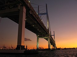
The Yokohama Bay Bridge (横浜ベイブリッジ, Yokohama Bei Buridji) is an 860 metres (2,820 ft) cable stayed bridge in Yokohama, Japan. Opened September 27, 1989, it crosses Tokyo Bay with a span of 460 metres (1,510 feet). The toll is ¥600. The bridge is part of the Bayshore Route of the Shuto Expressway.
Yokohama Bay Bridge | |
|---|---|
 | |
| Coordinates | 35°27′18″N 139°40′27″E / 35.4551°N 139.6742°E |
| Carries | 3 lanes of Bayshore Route (upper), 1 lane of National Route 357 (lower), prohibited to pedestrians or bicycles |
| Crosses | Port of Yokohama |
| Locale | between Honmoku and Daikoku Pier, Naka-ku, Yokohama, Kanagawa |
| Characteristics | |
| Design | Cable-stayed |
| Total length | 860 metres (2,820 ft)[1] |
| Width | 40.2 metres (132 ft) |
| Height | 172 metres (564 ft) |
| Longest span | 460 m (1,509.2 ft)[1] |
| Clearance above | Higher truck loads possible |
| Clearance below | 55 metres (180 ft) |
| History | |
| Opened | September 27, 1989 |
| Location | |
 | |
Notes edit
External links edit
 Media related to Yokohama Bay Bridge at Wikimedia Commons