


Summary
Yosemite Creek is a 15-mile-long (24 km) creek of the Sierra Nevada, located in Yosemite National Park, Mariposa County, California, United States.[1]
| Yosemite Creek | |
|---|---|
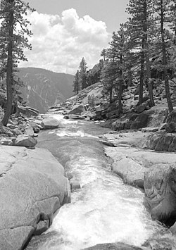 Yosemite Creek above its falls, circa 1981 | |
| Physical characteristics | |
| Length | 24 km (15 mi) |
| Basin size | 110 km2 (42 sq mi) |
Geography edit
The creek's headwaters are at the Grant Lakes (37°54′04″N 119°32′27″W / 37.90103°N 119.54072°W), and it flows southwest to drop 2,425 feet (739 m) over Yosemite Falls to Yosemite Valley, then flows southeast to its mouth at the Merced River, just southwest of Yosemite Village. (37°44′33″N 119°35′41″W / 37.74243°N 119.59461°W) [2] The Merced is a tributary of the San Joaquin River, in the San Joaquin Valley.
Today, Yosemite Creek flows over the Yosemite Valley rim to create Upper Yosemite Fall. Before its diversion about 130,000 years ago, Yosemite Creek flowed down an older channel just to the west, from which it cascaded down through the steep ravine that is now the route of the Yosemite Falls Trail.[3]
Hydrology edit
The Yosemite Creek watershed, which feeds the creek and Yosemite Falls, contains 43 square miles (110 km2). It is largely a granite basin that was scraped clean of soil by glaciers. Because of the shallow soil base, the Yosemite Creek watershed has little capacity to hold water, so it quickly drains as the snow melts.[4]
See also edit
References edit
- ^ U.S. Geological Survey. National Hydrography Dataset high-resolution flowline data. The National Map Archived 2012-03-29 at the Wayback Machine, accessed March 11, 2011
- ^ "Yosemite Creek". Geographic Names Information System. United States Geological Survey, United States Department of the Interior. Retrieved 2009-05-04.
- ^ N. King Huber (1922). The Geologic Story of Yosemite Valley (PDF).
- ^ "Yosemite at a Glance: Waterfalls". Yosemite National Park. Archived from the original on October 8, 2007.