


Summary
Yutian County (Chinese: 于田县), also transliterated from Uyghur as Keriya County (Uyghur: كېرىيە ناھىيىسى; Chinese: 克里雅县), is a county in Hotan Prefecture, Xinjiang Uyghur Autonomous Region, China. It is based at the Keriya Town, and is separate from Hotan County, which is another county in the same prefecture. The Yutian County has an area of 39,023 km2 (15,067 sq mi). According to the 2002 census, it has a population of 220,000. The county is bounded on the north by Aksu Prefecture, on the east by Minfeng/Niya County, on the west by Qira County and on the south by the Rutog and Gertse counties of the Tibet Autonomous Region.
Yutian County
Keriya County | |
|---|---|
 Kereya International On Foot Street | |
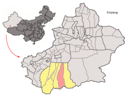 Location of the county (red) within Hotan Prefecture (yellow) and Xinjiang | |
 Yutian Location of the seat in Xinjiang  Yutian Yutian (Xinjiang)  Yutian Yutian (China) | |
| Coordinates: 36°52′N 81°42′E / 36.867°N 81.700°E | |
| Country | China |
| Autonomous region | Xinjiang |
| Prefecture | Hotan |
| County seat | Mughalla (Keriya) |
| Area | |
| • Total | 39,094.83 km2 (15,094.60 sq mi) |
| Population (2020)[2] | |
| • Total | 257,038 |
| • Density | 6.6/km2 (17/sq mi) |
| Ethnic groups | |
| • Major ethnic groups | Uyghur[3][4] |
| Time zone | UTC+8 (China Standard[a]) |
| Postal code | 848400 |
| Website | www |
| Yutian County, Xinjiang | |||||||||||
|---|---|---|---|---|---|---|---|---|---|---|---|
| Chinese name | |||||||||||
| Simplified Chinese | 于田县 | ||||||||||
| Traditional Chinese | 于田縣 | ||||||||||
| |||||||||||
| Alternative Chinese name | |||||||||||
| Simplified Chinese | 玉田县 | ||||||||||
| Traditional Chinese | 玉田縣 | ||||||||||
| |||||||||||
| Second alternative Chinese name | |||||||||||
| Simplified Chinese | 克里雅县 | ||||||||||
| Traditional Chinese | 克里雅縣 | ||||||||||
| |||||||||||
| Uyghur name | |||||||||||
| Uyghur | كېرىيە ناھىيىسى | ||||||||||
| |||||||||||
Name edit
The county derives its Chinese name from the Kingdom of Khotan. The name was written as '于闐' at that time.[5] This was later changed to '玉田' (literally, Jade Field) following the adoption of Simplified Chinese and eventually to '于田' in 1959.[6][7] The three names have a similar pronunciation in Mandarin Chinese.
"Keriya", the Latin transliteration of the Uyghur name for the county, is derived from the name of the Keriya River.
Yutian County is dubbed the "Home of Jade".[8]
History edit
The ancient name of Keriya was Yumi (扜彌, Gyuymi, Umi). The name Yumi was used by the Chinese envoy Zhang Qian in his 125 BCE report on his embassy's travels.
Yutian County (于阗县) was formed in 1882, its administrative center was Karakash, and Keriya was only a post station. In 1885, the administrative center of the county was moved to Keriya.
Aurel Stein travelled along the Keriya River in his early 20th century expeditions in the region.[9]
In 1920, the area was part of Hotan Dao (和闐道).[10]
In 1950, the area was part of Hotan Special Area (和闐專區).[10]
In 1959, the Chinese character name for the county was set as '于田'.[6][10]
In 1977, the area became part of Hotan Prefecture.[10]
In November 1980, the Yutian hydroelectric plant, located on the Keriya River, went into operation.[11]
On March 21, 2008, the county was at the epicenter of a 7.1/7.3 magnitude earthquake.[12][13]
In February 2014, the county was at the epicenter of the 6.8 magnitude 2014 Yutian earthquake. No injuries or deaths were reported.[14]
In 2018, the Financial Times reported that the Yutian county vocational training centre, among the largest of the Xinjiang internment camps, had opened a forced labour facility including eight factories spanning shoemaking, mobile phone assembly and tea packaging, giving a base monthly salary of ¥1,500 ($220). Between 2016 and 2018, the centre expanded 269 percent in total area.[15]
In 2018, Regiment 225 (兵团二二五团, part of Kunyu,[16] was listed as part of the county.[17]
Administrative divisions edit
Yutian county includes two towns and thirteen townships:[1][17][18]
| Name | Simplified Chinese | Hanyu Pinyin | Uyghur (UEY) | Uyghur Latin (ULY) | Administrative division code | |
|---|---|---|---|---|---|---|
| Towns | ||||||
| Mughalla Town | 木尕拉镇 | Mùgǎlā Zhèn | مۇغاللا بازىرى | mughalla baziri | 653226100 | |
| Xambabazar Town | 先拜巴扎镇 | Xiānbàibāzhā Zhèn | شەنبە بازار بازىرى | shenbebazar baziri | 653226101 | |
| Townships | ||||||
| Jay Township | 加依乡 | Jiāyī Xiāng | جاي يېزىسى | jay yëzisi | 653226200 | |
| Kokyar Township | 科克亚乡 | Kēkèyà Xiāng | كۆكيار يېزىسى[19] | kökyar yëzisi | 653226201 | |
| Aral Township | 阿热勒乡 | Ārèlè Xiāng | ئارال يېزىسى | Aral yëzisi | 653226202 | |
| Arix Township | 阿日希乡 | Ārìxī Xiāng | ئارىش يېزىسى | Arish yëzisi | 653226203 | |
| Lengger Township (Bogazlanggar) |
兰干乡 | Lángàn Xiāng | لەڭگەر يېزىسى | lengger yëzisi | 653226204 | |
| Siyak Township[20] | 斯也克乡 | Sīyěkè Xiāng | سىيەك يېزىسى | siyek yëzisi | 653226205 | |
| Togragaz Township (Tagdaxman) |
托格日尕孜乡 | Tuōgérìgǎzī Xiāng | توغراغاز يېزىسى | toghraghaz yëzisi | 653226206 | |
| Karaki Township | 喀拉克尔乡 | Kālākè'ěr Xiāng | قارقى يېزىسى | qarqi yëzisi | 653226207 | |
| Oytograk Township | 奥依托格拉克乡 | Àoyītuōgélākè Xiāng | ئويتوغراق يېزىسى | Oytoghraq yëzisi | 653226208 | |
| Aqqan Township | 阿羌乡 | Āqiāng Xiāng | ئاچچان يېزىسى | Achchan yëzisi | 653226209 | |
| Yengibag Township | 英巴格乡 | Yīngbāgé Xiāng | يېڭىباغ يېزىسى | yëngibagh yëzisi | 653226210 | |
| Shiwol Township | 希吾勒乡 | Xīwúlè Xiāng | شىۋول يېزىسى | shiwol yëzisi | 653226211 | |
| Darya Boyi Township | 达里雅布依乡 | Dálǐyǎbùyī Xiāng | دەريا بۇيى يېزىسى | deryabuyi yëzisi | 653226212 | |
Climate edit
| Climate data for Yutian (1991–2020 normals, extremes 1981–2010) | |||||||||||||
|---|---|---|---|---|---|---|---|---|---|---|---|---|---|
| Month | Jan | Feb | Mar | Apr | May | Jun | Jul | Aug | Sep | Oct | Nov | Dec | Year |
| Record high °C (°F) | 18.9 (66.0) |
23.8 (74.8) |
32.3 (90.1) |
36.0 (96.8) |
37.8 (100.0) |
39.2 (102.6) |
40.0 (104.0) |
40.5 (104.9) |
37.3 (99.1) |
31.5 (88.7) |
24.4 (75.9) |
18.7 (65.7) |
40.5 (104.9) |
| Mean daily maximum °C (°F) | 1.7 (35.1) |
7.7 (45.9) |
17.2 (63.0) |
24.5 (76.1) |
28.3 (82.9) |
31.2 (88.2) |
32.7 (90.9) |
31.5 (88.7) |
28.0 (82.4) |
21.6 (70.9) |
12.5 (54.5) |
3.9 (39.0) |
20.1 (68.1) |
| Daily mean °C (°F) | −4.8 (23.4) |
0.9 (33.6) |
9.6 (49.3) |
16.4 (61.5) |
20.2 (68.4) |
23.5 (74.3) |
24.9 (76.8) |
23.7 (74.7) |
19.1 (66.4) |
11.5 (52.7) |
4.0 (39.2) |
−2.8 (27.0) |
12.2 (53.9) |
| Mean daily minimum °C (°F) | −10.2 (13.6) |
−5.1 (22.8) |
2.4 (36.3) |
8.7 (47.7) |
12.8 (55.0) |
16.7 (62.1) |
18.4 (65.1) |
17.1 (62.8) |
11.8 (53.2) |
3.5 (38.3) |
−2.6 (27.3) |
−7.8 (18.0) |
5.5 (41.9) |
| Record low °C (°F) | −21.7 (−7.1) |
−22.8 (−9.0) |
−9.3 (15.3) |
−1.4 (29.5) |
0.7 (33.3) |
6.5 (43.7) |
10.0 (50.0) |
6.9 (44.4) |
1.0 (33.8) |
−4.2 (24.4) |
−11.6 (11.1) |
−22.6 (−8.7) |
−22.8 (−9.0) |
| Average precipitation mm (inches) | 1.8 (0.07) |
1.7 (0.07) |
1.9 (0.07) |
4.2 (0.17) |
5.9 (0.23) |
14.5 (0.57) |
11.8 (0.46) |
7.0 (0.28) |
8.3 (0.33) |
0.8 (0.03) |
0.4 (0.02) |
0.7 (0.03) |
59 (2.33) |
| Average precipitation days (≥ 0.1 mm) | 2.3 | 1.4 | 0.7 | 1.0 | 2.3 | 4.3 | 3.5 | 2.4 | 1.7 | 0.4 | 0.3 | 1.1 | 21.4 |
| Average snowy days | 4.7 | 2.2 | 0.7 | 0.1 | 0 | 0 | 0 | 0 | 0 | 0 | 0.7 | 3.2 | 11.6 |
| Average relative humidity (%) | 55 | 46 | 32 | 31 | 39 | 44 | 50 | 53 | 53 | 49 | 46 | 55 | 46 |
| Mean monthly sunshine hours | 206.0 | 203.8 | 234.8 | 240.9 | 264.7 | 260.0 | 254.8 | 240.6 | 256.0 | 279.9 | 239.2 | 212.8 | 2,893.5 |
| Percent possible sunshine | 66 | 66 | 63 | 60 | 60 | 59 | 58 | 58 | 70 | 82 | 79 | 71 | 66 |
| Source: China Meteorological Administration[21][22] | |||||||||||||
Economy edit
The county is known for its production of jade. Agriculture and livestock farming in the county produces corn, wheat, rice, cotton, grapes and melons. Industries in the county include jade mining, cotton ginning, tractor repair and preserved fruit processing.[6]
Demographics edit
As of 2015, 277,206 of the 282,182 residents of the county were Uyghur, 4,678 were Han Chinese and 298 were from other ethnic groups.[23]
In the late 2010s, Uyghurs made up 98.3% of the population of the county.[3]
As of 1999, 98.56% of the population of Keriya (Yutian) County was Uyghur and 1.37% of the population was Han Chinese.[24]
Transportation edit
- China National Highway 315
- Yutian Wanfang Airport
- Yutian railway station on Hotan–Ruoqiang railway
Notable persons edit
- Kurban Tulum, promoted by the Chinese Communist Party as a symbol of unity with the Uyghurs
Gallery edit
-
 Map including Kiriá (1865)
 -
![Map including Yutian (labeled as YÜ-TIEN (KERIYA) (YÜ-T'IEN)) and surrounding region in the International Map of the World (USATC, 1971)[b]](//upload.wikimedia.org/wikipedia/commons/thumb/0/00/Txu-oclc-6654394-nj-44-3rd-ed.jpg/220px-Txu-oclc-6654394-nj-44-3rd-ed.jpg) Map including Yutian (labeled as YÜ-TIEN (KERIYA) (YÜ-T'IEN)) and surrounding region in the International Map of the World (USATC, 1971)[b]
Map including Yutian (labeled as YÜ-TIEN (KERIYA) (YÜ-T'IEN)) and surrounding region in the International Map of the World (USATC, 1971)[b] -
 Map including Keriya (labeled as YÜ-TIEN (YUT'IEN) (ATC, 1971)
 -
 Map including the southern part of Yutian/Keriya County and the county's border with Tibet (AMS, 1950)
 -
![Map including Yutian (labeled as YUTIAN (YÜ-T'IEN)) and surrounding region (DMA, 1980)[c]](//upload.wikimedia.org/wikipedia/commons/thumb/f/fb/Operational_Navigation_Chart_G-7%2C_6th_edition.jpg/331px-Operational_Navigation_Chart_G-7%2C_6th_edition.jpg)

![Map including Yutian (labeled as YÜ-TIEN (KERIYA) (YÜ-T'IEN)) and surrounding region in the International Map of the World (USATC, 1971)[b]](http://upload.wikimedia.org/wikipedia/commons/thumb/0/00/Txu-oclc-6654394-nj-44-3rd-ed.jpg/220px-Txu-oclc-6654394-nj-44-3rd-ed.jpg)


![Map including Yutian (labeled as YUTIAN (YÜ-T'IEN)) and surrounding region (DMA, 1980)[c]](http://upload.wikimedia.org/wikipedia/commons/thumb/f/fb/Operational_Navigation_Chart_G-7%2C_6th_edition.jpg/331px-Operational_Navigation_Chart_G-7%2C_6th_edition.jpg)
Notes edit
- ^ Locals in Xinjiang frequently observe UTC+6 (Xinjiang Time), 2 hours behind Beijing.
- ^ (from map: "DELINEATION OF INTERNATIONAL BOUNDARIES MUST NOT BE CONSIDERED AUTHORITATIVE")
- ^ From map: "The representation of international boundaries is not necessarily authoritative."
References edit
- ^ a b 于田县历史沿革 [Yutian County Historical Development] (in Simplified Chinese). XZQH.org. 2 December 2014. Retrieved 11 December 2019.
2003年,于田县总面积39094.83平方千米,{...}2010年第六次人口普查,于田县常住总人口249899人,其中:木尕拉镇30179人,先拜巴扎镇19796人,加依乡17612人,科克亚乡18582人,阿热勒乡17941人,阿日希乡7664人,兰干乡19524人,斯也克乡21862人,托格日尕孜乡14573人,喀拉克尔乡14294人,奥依托格拉克乡18271人,阿羌乡8494人,英巴格乡9070人,希吾勒乡4312人,达里亚博依乡1281人,拉依苏良种场2489人,国营(昆仑)种羊场1580人,新城区街道13687人,老城区街道6159人,兰干博孜亚农场2529人。
- ^ Xinjiang: Prefectures, Cities, Districts and Counties
- ^ a b 于田县概况. 于田政府网 (in Simplified Chinese). Retrieved 22 January 2020.
于田县位于新疆维吾尔自治区南部,塔克拉玛干沙漠南缘,距首府1300公里,距和田180公里,全县总面积4.032万平方公里,总人口28.95万人,其中维吾尔族人口占全县总人口的98.3%,辖13个乡、2个镇、3个场、2个街道办事处,205个行政村,766个村民小组。
- ^ 1997年于田县行政区划 [1997 Keriya County Administrative Divisions]. XZQH.org. 6 January 2011. Retrieved 4 April 2020.
和田地区辖县。位于塔里木盆地南缘,南依昆仑山与西藏自治区接界。面积4万平方千米,人口19.4万,其中维吾尔族占98.6%。
- ^ "新疆于田县人民欢迎您!". Archived from the original on March 31, 2015. Retrieved April 21, 2015.
- ^ a b c 夏征农; 陈至立, eds. (September 2009). 辞海:第六版彩图本 [Cihai (Sixth Edition in Color)] (in Chinese). 上海. Shanghai: 上海辞书出版社. Shanghai Lexicographical Publishing House. p. 2781. ISBN 9787532628599.
1959年改于田县。{...}农、牧业发达,产玉米、小麦、稻、棉花、葡萄、瓜果等。以产玉著名。工业有玉石开采、轧棉、农机修理、果脯加工等。
- ^ "于田县历史沿革_区划人口_于田概况_走进于田_新疆于田县人民政府". Archived from the original on March 6, 2016. Retrieved April 21, 2015.
- ^ "于田县概况_历史沿革_于田概况_走进于田_新疆于田县人民政府". Archived from the original on March 4, 2016. Retrieved April 21, 2015.
- ^ "NJ 44 Ho-tien". Washington, D. C.: U.S. Army Topographic Command. 1971 – via Perry–Castañeda Library Map Collection.
STEIN 1906-08{...}K'o-lo-ya Ho
- ^ a b c d 于田县 - 历史. 于田政府网 (in Simplified Chinese). 15 January 2018. Retrieved 14 December 2019.
1920年隶和阗道。1950年属和阗专区。1959年县名简写为于田。1977年属和田地区。
- ^ "China's Xinjiang Uygur Autonomous Region: Cornucopia or Achilles Heel?". June 1981. p. 98 – via Internet Archive.
- ^ 新疆于田县今晨发生7.3级地震(图). Sina (in Simplified Chinese). 21 March 2008. Retrieved 14 December 2019.
- ^ Xiwei Xu; Xibin Tan; Guihua Yu; Guodong Wu; Wei Fang; Jianbo Chen; Heping Song; Jun Shen (22 January 2013). "Normal- and oblique-slip of the 2008 Yutian earthquake: Evidence for eastward block motion, northern Tibetan Plateau". Tectonophysics. 584: 152–165. Bibcode:2013Tectp.584..152X. doi:10.1016/j.tecto.2012.08.007.
- ^ Chris Buckley (12 February 2014). "Earthquake Strikes Remote Area of China". New York Times. Retrieved 14 December 2019.
- ^ Feng, Emily (16 December 2018). "Forced labour being used in China's 're-education' camps". Financial Times. Retrieved 13 December 2019.
Two of Xinjiang's largest internment camps — the Kashgar city and Yutian county vocational training centres — have opened forced labour facilities this year. Yutian's detention centre boasts eight factories specialising in vocations such as shoemaking, mobile phone assembly and tea packaging, offering a base monthly salary of Rmb1,500 ($220), according to Chinese state media reports. Satellite images show that Kashgar's internment centre has more than doubled in size since 2016 and Yutian's grew 269 per cent over the same period, according to a report compiled by the Australian Strategic Policy Institute, a think-tank.
- ^ 兵团第十四师昆玉市225团成立. خوتەن 和田政府网 (in Simplified Chinese). 9 May 2016. Retrieved 24 December 2019.
新疆生产建设兵团第十四师昆玉市225团成立暨新城区建设奠基仪式在这里举行。{...}于田县"两场一区"兵地共建筹备领导小组与兵团第十四师昆玉市225团筹备工作领导小组共同签署移交接管协议
- ^ a b 2018年统计用区划代码和城乡划分代码:于田县 [2018 Statistical Area Numbers and Rural-Urban Area Numbers: Yutian County] (in Simplified Chinese). National Bureau of Statistics of the People's Republic of China. 2018. Retrieved 11 December 2019.
统计用区划代码 名称 653226100000 木尕拉镇 653226101000 先拜巴扎镇 653226200000 加依乡 653226201000 科克亚乡 653226202000 阿热勒乡 653226203000 阿日希乡 653226204000 兰干乡 653226205000 斯也克乡 653226206000 托格日尕孜乡 653226207000 喀拉克尔乡 653226208000 奥依托格拉克乡 653226209000 阿羌乡 653226210000 英巴格乡 653226211000 希吾勒乡 653226212000 达里雅布依乡 653226401000 国营(昆仑)种羊场 653226402000 于田监狱 653226500000 兵团二二五团
- ^ 于田县行政区. 于田政府网 (in Simplified Chinese). 22 March 2018. Archived from the original on 11 December 2019. Retrieved 11 December 2019.
于田县辖2个镇、13个乡:木尕拉镇、先拜巴扎镇、加依乡、科克亚乡、阿热勒乡、阿日希乡、兰干乡、斯也克乡、托格日尕孜乡、喀拉克尔乡、奥依托格拉克乡、阿羌乡、英巴格乡、希吾勒乡、达里雅布依乡。县人民政府驻木尕拉镇。
- ^ قۇربانجان قېيۇم, ed. (28 February 2019). ۋۇ گاڭ: ۋەزىپە، مەسئۇلىيىتىمنى تولۇق ئادا قىلىپ، جەمئىيەت كۆڭۈل بۆلۈۋاتقان مەسىلىلەرنى ئىنكاس قىلىمەن. Tianshannet (in Uyghur). Retrieved 13 May 2020.
كېرىيە ناھىيەسىنىڭ كۆكيار يېزىسى
- ^ huaxia, ed. (17 September 2020). "Full Text: Employment and Labor Rights in Xinjiang". Xinhua News Agency. Retrieved 20 September 2020.
Amina Obul from Siyak Township, Yutian (Keriya) County, Hotan Prefecture
- ^ 中国气象数据网 – WeatherBk Data (in Simplified Chinese). China Meteorological Administration. Retrieved 10 October 2023.
- ^ 中国气象数据网 (in Simplified Chinese). China Meteorological Administration. Retrieved 10 October 2023.
- ^ 3-7 各地、州、市、县(市)分民族人口数 (in Simplified Chinese). شىنجاڭ ئۇيغۇر ئاپتونوم رايونى 新疆维吾尔自治区统计局 Statistic Bureau of Xinjiang Uygur Autonomous Region. 15 March 2017. Archived from the original on 11 October 2017. Retrieved 3 September 2017.
- ^ Morris Rossabi, ed. (2004). Governing China's Multiethnic Frontiers (PDF). University of Washington Press. p. 180. ISBN 0-295-98390-6.