
KNOWPIA
WELCOME TO KNOWPIA

Zaessingue 
Summary
Zaessingue (French pronunciation: [t͡sɛsɛ̃g]; Alemannic German: Zäsige; German: Zässingen) is a commune in the Haut-Rhin department in Alsace in north-eastern France.[3]
Zaessingue
Zäsige | |
|---|---|
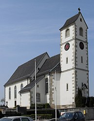 St. Peter and Paul Church | |
 Coat of arms | |
Location of Zaessingue .mw-parser-output .locmap .od{position:absolute}.mw-parser-output .locmap .id{position:absolute;line-height:0}.mw-parser-output .locmap .l0{font-size:0;position:absolute}.mw-parser-output .locmap .pv{line-height:110%;position:absolute;text-align:center}.mw-parser-output .locmap .pl{line-height:110%;position:absolute;top:-0.75em;text-align:right}.mw-parser-output .locmap .pr{line-height:110%;position:absolute;top:-0.75em;text-align:left}.mw-parser-output .locmap .pv>div{display:inline;padding:1px}.mw-parser-output .locmap .pl>div{display:inline;padding:1px;float:right}.mw-parser-output .locmap .pr>div{display:inline;padding:1px;float:left}html.skin-theme-clientpref-night .mw-parser-output .od,html.skin-theme-clientpref-night .mw-parser-output .od .pv>div,html.skin-theme-clientpref-night .mw-parser-output .od .pl>div,html.skin-theme-clientpref-night .mw-parser-output .od .pr>div{background:#000;color:#fff}html.skin-theme-clientpref-night .mw-parser-output .locmap{filter:grayscale(0.6)}@media(prefers-color-scheme:dark){html.skin-theme-clientpref-os .mw-parser-output .locmap{filter:grayscale(0.6)}html.skin-theme-clientpref-os .mw-parser-output .od,html.skin-theme-clientpref-os .mw-parser-output .od .pv>div,html.skin-theme-clientpref-os .mw-parser-output .od .pl>div,html.skin-theme-clientpref-os .mw-parser-output .od .pr>div{background:#000;color:#fff}}  Zaessingue  Zaessingue | |
| Coordinates: 47°37′26″N 7°22′04″E / 47.6239°N 7.3678°E | |
| Country | France |
| Region | Grand Est |
| Department | Haut-Rhin |
| Arrondissement | Mulhouse |
| Canton | Brunstatt-Didenheim |
| Intercommunality | Saint-Louis Agglomération |
| Government | |
| • Mayor (2020–2026) | Roger Zinniger[1] |
| Area 1 | 4.99 km2 (1.93 sq mi) |
| Population (2021)[2] | 386 |
| • Density | 77/km2 (200/sq mi) |
| Demonym(s) | Zaessinguois, Zaessinguoises |
| Time zone | UTC+01:00 (CET) |
| • Summer (DST) | UTC+02:00 (CEST) |
| INSEE/Postal code | 68382 /68130 |
| Elevation | 338–412 m (1,109–1,352 ft) (avg. 345 m or 1,132 ft) |
| 1 French Land Register data, which excludes lakes, ponds, glaciers > 1 km2 (0.386 sq mi or 247 acres) and river estuaries. | |
Population edit
|
| ||||||||||||||||||||||||||||||||||||||||||||||||||||||||||||||||||||||||||||||||||||||||||||||||||||||||||||||||||
| Source: EHESS (1793-1999)[4] and INSEE[5] | |||||||||||||||||||||||||||||||||||||||||||||||||||||||||||||||||||||||||||||||||||||||||||||||||||||||||||||||||||
See also edit
References edit
- ^ "Répertoire national des élus: les maires" (in French). data.gouv.fr, Plateforme ouverte des données publiques françaises. 13 September 2022.
- ^ "Populations légales 2021". The National Institute of Statistics and Economic Studies. 28 December 2023.
- ^ Commune de Zaessingue (68382), INSEE
- ^ Des villages de Cassini aux communes d'aujourd'hui: Commune data sheet Zaessingue, EHESS (in French).
- ^ Population en historique depuis 1968, INSEE
External links edit
- official website of the village of Zaessingue (in French)
Wikimedia Commons has media related to Zaessingue.