


Summary
Zaqatala (Azerbaijani: Zaqatala, Avar: Закатала / Чӏар, Tsakhur: Гал) is a city in northwestern Azerbaijan and the administrative center of the Zagatala District. It has a municipal population of 31,300 inhabitants and is located on the Tala River. The municipality consists of the city of Zaqatala and the nearby village of Qazangül.[3]
Zaqatala
Закатала / Чlaр Гал | |
|---|---|
City & Municipality | |
 Nature of Zaqatala | |
 Zaqatala Location of Zagatala  Zaqatala Zaqatala (Shaki-Zagatala Economic Region) | |
| Coordinates: 41°38′1″N 46°38′36″E / 41.63361°N 46.64333°E | |
| Country | |
| District | Zagatala |
| Elevation | 518 m (1,702 ft) |
| Population | |
| • Total | 32,171 |
| Time zone | UTC+4 (AZT) |
| Website | zaqatala-ih |
The city is populated mostly by Azerbaijanis, but with significant minorities of the indigenous Avar, Lezgin, Tsakhur and Ingiloy peoples.
History edit
The territory of modern Zaqatala was once a province of Caucasian Albania. After that, the region was a separate kingdom within Georgian cultural and political influence. During the medieval era what later became known as Saingilo was mostly controlled by the kingdom of Georgia and Shirvan.
In the Middle Ages seven Georgian schools operated in Saingilo which included the courses of theology, philosophy, orthography, church history, and the history of Georgia and for the students. These schools played an essential cultural and educational role. They put a vital contribution in establishing cultural relations among the peoples of the Caucasus.
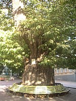
Zaqatala has several sites of historic significance, most of which are centred on its 19th-century town centre. The main square, formerly called Lenin Square, features a pair of 700-year-old plane trees.
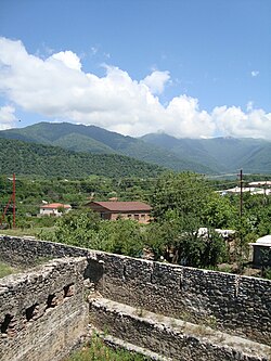
The city's most prominent feature is a ruined fortress (Russian: "Кала"),[4] built in the 1830s by occupying Russian forces during the Caucasian War to defend the city from rebels (See Djaro-Belokani league). In the 1850s, the town was the site of battles between Russians and Dagestani leader Imam Shamil.[5] It was center of Zakatal Okrug ("district") of the Tiflis Governorate between 1893 and 1905. It was part of the Transcaucasian Democratic Federative Republic briefly in 1918 before passing to the Azerbaijan Democratic Republic and later the Azerbaijan SSR.[6][7][8] In the 20th century the town and its fortress became more famous when the fortress was used as one of the prisons for the mutinous crew of the battleship Potëmkin, whose actions in the failed 1905 Revolution were a precursor to the eventual 1917 revolution. At the end of the 1980s, however, the fortress was in a neglected and extremely dilapidated state and its area was used for cattle pasture in the summer.[4] The statue of one of the mutineers erected in the Soviet era still decorates Heydar Aliyev park not far from the fortress.[9] Currently, the fortress still houses a military garrison as well as several Soviet-style apartment buildings. Near the northern part of the ramparts and off of the main square is a beautiful, but abandoned, church.[10] The town now sports a sizable new mosque.[11]
Overview edit
It is served by the A315 road coming from Mingachevir and leading to the Georgian border at Lagodekhi as well as by a small airfield. North of the town there is an important wildlife and nature preserve. The Caucasus Mountains provide it with natural protection from the north winds. The wooded mountainsides, with frequent waterfalls, offer great hiking opportunities. Due to its climate, the town became a mountain health resort.[citation needed]
There are several hotels in both Zaqatala and surrounding villages including Ashaghi Tala and Jar, both about 3 kilometres (1.9 mi) from Zaqatala.
Sports edit

The city has 2 professional football teams, Simurg and Zagatala PFK. Zaqatala City Stadium located in Galaduzu area was inaugurated in 2008 within the Zagatala Olimpic Sports Complex. It has a capacity of 3,500 people.[12][13]
Demographics edit
Majority of the city and the district are ethnic Azerbaijanis with significant minorities of Avars, Lezgins, Tsakhurs and Ingiloys. The majority of population are Sunni Muslim, with Orthodox Christians (mostly Ingiloys) minorities.[14]
| Ethnic group | 1876[15] | 1897[16] | 1916[17] | 1926[18] | 1939[19] | 1959[20] | 1970[21] | 1979[22] | ||||||||
|---|---|---|---|---|---|---|---|---|---|---|---|---|---|---|---|---|
| Number | % | Number | % | Number | % | Number | % | Number | % | Number | % | Number | % | Number | % | |
| Azerbaijanis | 23 | 2.01 | 299 | 9.94 | 1,092 | 24.24 | 1,284 | 38.86 | 2,577 | 29.99 | 5,362 | 52.31 | 7 877 | 58.88 | 9,678 | 63.69 |
| Avars | 589 | 19.57 | 10 | 0.30 | 480 | 5.59 | 299 | 2.92 | 1,133 | 8.47 | 1,446 | 9.52 | ||||
| Tsakhurs | 213 | 6.45 | 232 | 2.70 | 71 | 0.69 | 831 | 6.21 | 1,330 | 8.75 | ||||||
| Russians | 240 | 21.00 | 258 | 8.57 | 270 | 5.99 | 290 | 8.78 | 2,986 | 34.75 | 1,876 | 18.30 | 1,261 | 9.43 | 951 | 6.26 |
| Armenians | 400 | 35.00 | 1,400 | 46.53 | 2,165 | 48.06 | 1,181 | 35.74 | 1,414 | 16.45 | 1,215 | 11.85 | 982 | 7.34 | 836 | 5.50 |
| Lezgins | 455 | 39.81 | 22 | 0.73 | 117 | 3.54 | 222 | 2.58 | 824 | 8.04 | 478 | 3.57 | 351 | 2.31 | ||
| Georgians | 5 | 0.44 | 191 | 6.35 | 204 | 4.53 | 96 | 2.91 | 144 | 1.68 | 137 | 1.34 | 307 | 2.29 | 91 | 0.60 |
| Others | 20 | 1.75 | 250 | 8.31 | 774 | 17.18 | 113 | 3.42 | 539 | 6.27 | 466 | 4.55 | 508 | 3.80 | 512 | 3.37 |
| TOTAL | 1,143 | 100.00 | 3,009 | 100.00 | 4,505 | 100.00 | 3,304 | 100.00 | 8,594 | 100.00 | 10,250 | 100.00 | 13,377 | 100.00 | 15,195 | 100.00 |
Transportation edit
Zaqatala International Airport serves the city.[23][24] The airport is connected by bus to the city center. There are domestic flights to Baku, however currently it is unavailable.
There are two bus stations in Zaqatala. One is in the centre, near the Farmer's Market. This bus station serves only the villages of Zaqatala. The second bus station is out of the centre, and this station serves the other cities and capital. Customers can buy the tickets directly at the bus station. Reaching this Bus station passengers can either take public transports or taxi. There is a railway station to Zaqatala and it connects Baku (the capital) to Zaqatala with a 12-hour ride.
Climate edit
Zaqatala has a humid subtropical climate (Cfa) according to the Köppen climate classification.
| Climate data for Zaqatala (1971–1990, extremes 1952–1994) | |||||||||||||
|---|---|---|---|---|---|---|---|---|---|---|---|---|---|
| Month | Jan | Feb | Mar | Apr | May | Jun | Jul | Aug | Sep | Oct | Nov | Dec | Year |
| Record high °C (°F) | 20.0 (68.0) |
23.9 (75.0) |
27.8 (82.0) |
31.1 (88.0) |
36.1 (97.0) |
36.1 (97.0) |
38.9 (102.0) |
38.9 (102.0) |
37.2 (99.0) |
32.8 (91.0) |
25.0 (77.0) |
22.8 (73.0) |
38.9 (102.0) |
| Mean daily maximum °C (°F) | 5.3 (41.5) |
6.3 (43.3) |
11.2 (52.2) |
18.8 (65.8) |
22.2 (72.0) |
26.8 (80.2) |
30.5 (86.9) |
29.3 (84.7) |
25.7 (78.3) |
18.8 (65.8) |
12.5 (54.5) |
7.9 (46.2) |
17.9 (64.2) |
| Daily mean °C (°F) | 1.1 (34.0) |
2.3 (36.1) |
5.8 (42.4) |
12.7 (54.9) |
17.0 (62.6) |
20.9 (69.6) |
24.6 (76.3) |
23.7 (74.7) |
19.8 (67.6) |
13.5 (56.3) |
7.9 (46.2) |
3.2 (37.8) |
12.7 (54.9) |
| Mean daily minimum °C (°F) | −1.9 (28.6) |
−1.1 (30.0) |
2.7 (36.9) |
8.0 (46.4) |
12.0 (53.6) |
16.1 (61.0) |
19.4 (66.9) |
18.6 (65.5) |
15.0 (59.0) |
9.4 (48.9) |
4.6 (40.3) |
0.4 (32.7) |
8.6 (47.5) |
| Record low °C (°F) | −22.8 (−9.0) |
−13.9 (7.0) |
−12.2 (10.0) |
−3.9 (25.0) |
1.1 (34.0) |
6.1 (43.0) |
8.9 (48.0) |
7.8 (46.0) |
2.2 (36.0) |
−5.0 (23.0) |
−7.8 (18.0) |
−18.9 (−2.0) |
−22.8 (−9.0) |
| Average precipitation mm (inches) | 35 (1.4) |
52 (2.0) |
67 (2.6) |
78 (3.1) |
115 (4.5) |
129 (5.1) |
64 (2.5) |
75 (3.0) |
65 (2.6) |
106 (4.2) |
72 (2.8) |
33 (1.3) |
891 (35.1) |
| Average precipitation days | 7 | 8 | 11 | 12 | 13 | 10 | 7 | 7 | 7 | 9 | 8 | 7 | 106 |
| Mean monthly sunshine hours | 114.3 | 103.8 | 130.0 | 176.7 | 215.6 | 261.0 | 274.8 | 255.3 | 220.2 | 157.8 | 130.5 | 110.2 | 2,150.2 |
| Source 1: NOAA[25] | |||||||||||||
| Source 2: Sistema de Clasificación Bioclimática Mundial[26] | |||||||||||||
Gallery edit
-
 Park in Zaqatala
 -
 Zaqatala Fortress
 -
![Abandoned church [az] in Zaqatala](//upload.wikimedia.org/wikipedia/commons/thumb/b/bb/Church_of_Zaqatala_2.jpg/405px-Church_of_Zaqatala_2.jpg) Abandoned church in Zaqatala
Abandoned church in Zaqatala


![Abandoned church [az] in Zaqatala](http://upload.wikimedia.org/wikipedia/commons/thumb/b/bb/Church_of_Zaqatala_2.jpg/405px-Church_of_Zaqatala_2.jpg)
References edit
- ^ "Zaqatala, Azerbaijan page". Retrieved 2008-07-03.
- ^ "Əhalisi - ZAQATALA RAYON Icra Hakimiyyəti". zaqatala-ih.gov.az.
- ^ "Belediyye Informasiya Sistemi" (in Azerbaijani). Archived from the original on September 24, 2008.
- ^ a b Huseynova, Leila (1990). Development and Preservation of Architectural and Artistic Originality of Azerbaijan's Cities. Ministry of National Education Azerbaijan SSR. p. 52.
- ^ Elliott, Mark (2010). "Azerbaijan with excursions to Georgia" (4th ed.). p. 237.
- ^ Daushvili, Aleko (2012-01-01). "The Democratic Republic of Georgia: Struggle for Independence 1918-1921": 41.
By autumn of 1918 the Zakatala district was officially a part of the Republic of Azerbaijan. Having the support of Turkey and the convenience of a shared Islamic religion, the Azerbaijani state heavily enforced anti-Georgian propaganda in the region. With the help of local mullahs, the Muslim-Georgian population easily came under Azerbaijani influence, which in turn created the illusion that Zakatala was fully incorporated into Azerbaijan.
{{cite journal}}: Cite journal requires|journal=(help) - ^ Javakhishvili, Ivane (2011). CAUCASIOLOGIC PAPERS (PDF). Tbilisi: Tbilisi State University. p. 235.
Simultaneously, Georgia and Azerbaijan have tried to include Zakatala District ... Georgia's attempts were unsuccessful, because the Georgians were less than 20% of the population of the district, and the stake was only on them. Azerbaijan … [was] more successful in their attempts, because the idea appealed to Islamic unity.
- ^ Yilmaz, Harun (2009-06-01). "An Unexpected Peace: Azerbaijani–Georgian Relations, 1918–20". Revolutionary Russia. 22 (1): 37–67. doi:10.1080/09546540902900288. ISSN 0954-6545. S2CID 143471218.
There were sizeable Muslim populations in Kutaisi and Tbilisi provinces, which remained in Georgia, and a minority of Christians in Zakatala okrug, in Azerbaijan.
- ^ Nicas, Peter. "Azerbaijan Things to See & Do Guide". ProfessionalTravelGuide.com. Retrieved 2008-06-17. [dead link]
- ^ Torres Curado, L.M. "Zaqatala (Zakataly)". Azerb.com. Retrieved 2008-01-03.
- ^ Elliott, Mark (2010). "Azerbaijan with excursions to Georgia" (4th ed.). p. 234.
- ^ "Sport in Zaqatala". Executive Power of Zaqatala. Retrieved 2019-04-30.
- ^ "ZAQATALA ŞƏHƏR STADİONU UEFA STANDARTLARINA CAVAB VERİR". azertag.az (in Azerbaijani). Retrieved 2019-04-30.
- ^ Clifton, John M. (2005). "The Sociolinguistic Situation of the Tsakhur in Azerbaijan" (PDF). SIL International. Retrieved 2008-06-02.
- ^ Кавказский календарь на 1886 год [Caucasian calendar for 1886] (in Russian) (41st ed.). Tiflis: Tipografiya kantselyarii Ye.I.V. na Kavkaze, kazenny dom. 1886. p. 134. Archived from the original on 16 December 2021.
- ^ "Демоскоп Weekly - Приложение. Справочник статистических показателей". www.demoscope.ru. Retrieved 2022-08-03.
- ^ Кавказский календарь на 1917 год [Caucasian calendar for 1917] (in Russian) (72nd ed.). Tiflis: Tipografiya kantselyarii Ye.I.V. na Kavkaze, kazenny dom. 1917. pp. 357–358. Archived from the original on 4 November 2021.
- ^ Ethno-Caucasus :Zagatala Uyezd, 1926
- ^ Ethno-Caucasus :Zagatala District, 1939
- ^ Ethno-Caucasus :Zagatala District, 1959
- ^ Ethno-Caucasus :Zagatala District, 1970
- ^ Ethno-Caucasus :Zagatala District, 1979
- ^ "Zaqatala Airport". Azerbaijan Airlines. Archived from the original on 23 August 2011. Retrieved 22 August 2011.
- ^ "Zaqatala beynəlxalq hava limanı yenidən fəaliyyətə başlayıb" (in Azerbaijani). milli.az. Archived from the original on 7 September 2012. Retrieved 22 August 2011.
- ^ "Zagatala Climate Normals 1961–1990". National Oceanic and Atmospheric Administration. Retrieved March 22, 2015.
- ^ "Zakataly (Azerbaijan)" (PDF). Centro de Investigaciones Fitosociológicas. Retrieved February 1, 2016.
External links edit
- Zaqatala at GEOnet Names Server
41°38′01″N 46°38′36″E / 41.63361°N 46.64333°E