


Summary
Zelenodolsk (Russian: Зеленодо́льск; Tatar: Яшел Үзән; Mari: Парат, Parat) is a town in Tatarstan, Russia, located in the northwest of the republic on the left bank of the Volga River, 38 kilometers (24 mi) from Kazan. Population: 97,674 (2010 Census);[2] 100,139 (2002 Census);[8] 94,079 (1989 Census).[9]
Zelenodolsk
Зеленодольск | |
|---|---|
| Other transcription(s) | |
| • Tatar | Яшел Үзән |
 Aerial view of Zelenodolsk | |
 Flag  Coat of arms | |
Location of Zelenodolsk .mw-parser-output .locmap .od{position:absolute}.mw-parser-output .locmap .id{position:absolute;line-height:0}.mw-parser-output .locmap .l0{font-size:0;position:absolute}.mw-parser-output .locmap .pv{line-height:110%;position:absolute;text-align:center}.mw-parser-output .locmap .pl{line-height:110%;position:absolute;top:-0.75em;text-align:right}.mw-parser-output .locmap .pr{line-height:110%;position:absolute;top:-0.75em;text-align:left}.mw-parser-output .locmap .pv>div{display:inline;padding:1px}.mw-parser-output .locmap .pl>div{display:inline;padding:1px;float:right}.mw-parser-output .locmap .pr>div{display:inline;padding:1px;float:left}html.skin-theme-clientpref-night .mw-parser-output .od,html.skin-theme-clientpref-night .mw-parser-output .od .pv>div,html.skin-theme-clientpref-night .mw-parser-output .od .pl>div,html.skin-theme-clientpref-night .mw-parser-output .od .pr>div{background:#000;color:#fff}html.skin-theme-clientpref-night .mw-parser-output .locmap{filter:grayscale(0.6)}@media(prefers-color-scheme:dark){html.skin-theme-clientpref-os .mw-parser-output .locmap{filter:grayscale(0.6)}html.skin-theme-clientpref-os .mw-parser-output .od,html.skin-theme-clientpref-os .mw-parser-output .od .pv>div,html.skin-theme-clientpref-os .mw-parser-output .od .pl>div,html.skin-theme-clientpref-os .mw-parser-output .od .pr>div{background:#000;color:#fff}}  Zelenodolsk Location of Zelenodolsk  Zelenodolsk Zelenodolsk (Tatarstan) | |
| Coordinates: 55°51′N 48°31′E / 55.850°N 48.517°E | |
| Country | Russia |
| Federal subject | Tatarstan[1] |
| Founded | 1865 |
| Town status since | 1932 |
| Elevation | 90 m (300 ft) |
| Population | |
| • Total | 97,674 |
| • Estimate (2018)[3] | 99,491 (+1.9%) |
| • Rank | 173rd in 2010 |
| • Subordinated to | town of republic significance of Zelenodolsk[1] |
| • Capital of | town of republic significance of Zelenodolsk,[1] Zelenodolsky District[1] |
| • Municipal district | Zelenodolsky Municipal District[4] |
| • Urban settlement | Zelenodolsk Urban Settlement[4] |
| • Capital of | Zelenodolsky Municipal District,[4] Zelenodolsk Urban Settlement[4] |
| Time zone | UTC+3 (MSK |
| Postal code(s)[6] | 422540–422542, 422544–422546, 422548–422551, 422559 |
| Dialing code(s) | +7 84371[7] |
| OKTMO ID | 92628101001 |
History edit
The city stands on the site of Mari village. In 1865, the town was referred to as the village Kabachischi (the title area of arable land Paratsky peasants "Kabachischenskie field"). Since 1897 the village was called Paratsky Zaton, and since 1928 working village Green Dol. In 1932, transformed into a city Zelenodol'sk.[citation needed]
Since the end of the 19th century, it was the backwater wintering area and repair of sea vessels, which marked the beginning Zelenodolsk Shipyard (now Zelenodolsky Plant Gorky).
As a result of the rising water level of the Kuibyshev Reservoir and coastal flooding during construction of the Kuibyshev hydroelectric station, the coastline has changed dramatically.
Now[when?] beginning to be realized[by whom?] the largest public-private investment project to build by 2025 within the territory of the agglomeration of 3.64 ha along the M7 motorway between Zelenodol'sk and Kazan new satellite city "Green Dol" with an estimated population of 100 (hereinafter - 157) thousand, housing stock 4,100,000 m2, construction cost 140 billion rubles. with predominantly low-rise, multi-story buildings in the passing of the planned neighborhood Zelenodol "Volga Venice" on reclaimed lands Aysha and continue through Orehovka.[citation needed]
Administrative and municipal status edit
Within the framework of administrative divisions, Zelenodolsk serves as the administrative center of Zelenodolsky District, even though it is not a part of it.[1] As an administrative division, it is incorporated separately as the town of republic significance of Zelenodolsk—an administrative unit with the status equal to that of the districts.[1] As a municipal division, the town of republic significance of Zelenodolsk is incorporated within Zelenodolsky Municipal District as Zelenodolsk Urban Settlement.[4]
Economy edit
Due to its location, Zelenodolsk is an important transport hub of the republic. It also has a well-known shipbuilding yard (Zelenodolsk Factory), founded in 1895.
During the Cold War, Zelenodolsk was a secret development base for warships.
-
 Plywood factory in Zelenodolsk
 -
 Tynychlyk Mosque
 -
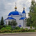 Saint Andrew Church
 -
 Freight trains at Zeleny Dol station
 -
 Building of Zeleny Dol station


References edit
Notes edit
- ^ a b c d e f g Order #01-02/9
- ^ a b Russian Federal State Statistics Service (2011). Всероссийская перепись населения 2010 года. Том 1 [2010 All-Russian Population Census, vol. 1]. Всероссийская перепись населения 2010 года [2010 All-Russia Population Census] (in Russian). Federal State Statistics Service.
- ^ "26. Численность постоянного населения Российской Федерации по муниципальным образованиям на 1 января 2018 года". Federal State Statistics Service. Retrieved January 23, 2019.
- ^ a b c d e Law #24-ZRT
- ^ "Об исчислении времени". Официальный интернет-портал правовой информации (in Russian). June 3, 2011. Retrieved January 19, 2019.
- ^ Почта России. Информационно-вычислительный центр ОАСУ РПО. (Russian Post). Поиск объектов почтовой связи (Postal Objects Search) (in Russian)
- ^ The extract from Numbering base of Russian numeration system and plan
- ^ Russian Federal State Statistics Service (May 21, 2004). Численность населения России, субъектов Российской Федерации в составе федеральных округов, районов, городских поселений, сельских населённых пунктов – районных центров и сельских населённых пунктов с населением 3 тысячи и более человек [Population of Russia, Its Federal Districts, Federal Subjects, Districts, Urban Localities, Rural Localities—Administrative Centers, and Rural Localities with Population of Over 3,000] (XLS). Всероссийская перепись населения 2002 года [All-Russia Population Census of 2002] (in Russian).
- ^ Всесоюзная перепись населения 1989 г. Численность наличного населения союзных и автономных республик, автономных областей и округов, краёв, областей, районов, городских поселений и сёл-райцентров [All Union Population Census of 1989: Present Population of Union and Autonomous Republics, Autonomous Oblasts and Okrugs, Krais, Oblasts, Districts, Urban Settlements, and Villages Serving as District Administrative Centers]. Всесоюзная перепись населения 1989 года [All-Union Population Census of 1989] (in Russian). Институт демографии Национального исследовательского университета: Высшая школа экономики [Institute of Demography at the National Research University: Higher School of Economics]. 1989 – via Demoscope Weekly.
Sources edit
- Министерство юстиции Республики Татарстан. Приказ №01-02/9 от 4 февраля 2014 г. «Об утверждении реестра административно-территориальных единиц и населённых пунктов в Республике Татарстан», в ред. Приказа №01-02/160 от 11 марта 2015 г. «О внесении изменений в Приказ Министерства юстиции Республики Татарстан от 04.02.2014 №01-02/9 "Об утверждении реестра административно-территориальных единиц и населённых пунктов в Республике Татарстан"». Опубликован: Официальный сайт правовой информации Министерства юстиции Республики Татарстан (http://pravo.tatarstan.ru), 27 февраля 2014 г. (Ministry of Justice of the Republic of Tatarstan. Order #01-02/9 of February 4, 2014 On the Adoption of the Registry of the Administrative-Territorial Units and Inhabited Localities in the Republic of Tatarstan, as amended by the Order #01-02/160 of March 11, 2015 On Amending the Order of the Ministry of Justice of the Republic of Tatarstan #01-02/9 of February 4, 2014 "On the Adoption of the Registry of the Administrative-Territorial Units and Inhabited Localities in the Republic of Tatarstan". ).
- Государственный Совет Республики Татарстан. Закон №24-ЗРТ от 31 января 2005 г. «Об установлении границ территорий и статусе муниципального образования "Зеленодольский муниципальный район" и муниципальных образований в его составе», в ред. Закона №71-ЗРТ от 7 октября 2015 г. «Об изменении границ территорий отдельных муниципальных образований и внесении изменений в Закон Республики Татарстан "Об установлении границ территорий и статусе муниципального образования "Зеленодольский муниципальный район" и муниципальных образований в его составе"». Вступил в силу со дня официального опубликования. Опубликован: "Республика Татарстан", №№18–19, 1 февраля 2005 г. (State Council of the Republic of Tatarstan. Law #24-ZRT of January 31, 2005 On Establishing the Borders of the Territories and the Status of the Municipal Formation of "Zelenodolsky Municipal District" and of the Municipal Formations It Comprises, as amended by the Law #71-ZRT of October 7, 2015 On Changing the Borders of the Territories of Several Municipal Formations and Amending the Law of the Republic of Tatarstan "On Establishing the Borders of the Territories and the Status of the Municipal Formation of "Zelenodolsky Municipal District" and of the Municipal Formations It Comprises". Effective as of the official publication date.).
External links edit
- Unofficial website of Zelenodolsk (in Russian)