
KNOWPIA
WELCOME TO KNOWPIA

Zemst 
Summary
Zemst (Dutch pronunciation: [zɛmst]) is a municipality located in the Belgian province of Flemish Brabant. The municipality comprises the villages of Elewijt, Eppegem, Hofstade, Weerde, Zemst-Laar, Zemst-Bos and Zemst proper. On January 1, 2006, Zemst had a total population of 21,327. The total area is 42.83 km2 which gives a population density of 498 inhabitants per km2.
Zemst | |
|---|---|
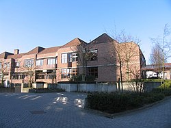 Town hall of Zemst | |
 Flag  Coat of arms | |
Location of Zemst .mw-parser-output .locmap .od{position:absolute}.mw-parser-output .locmap .id{position:absolute;line-height:0}.mw-parser-output .locmap .l0{font-size:0;position:absolute}.mw-parser-output .locmap .pv{line-height:110%;position:absolute;text-align:center}.mw-parser-output .locmap .pl{line-height:110%;position:absolute;top:-0.75em;text-align:right}.mw-parser-output .locmap .pr{line-height:110%;position:absolute;top:-0.75em;text-align:left}.mw-parser-output .locmap .pv>div{display:inline;padding:1px}.mw-parser-output .locmap .pl>div{display:inline;padding:1px;float:right}.mw-parser-output .locmap .pr>div{display:inline;padding:1px;float:left}html.skin-theme-clientpref-night .mw-parser-output .od,html.skin-theme-clientpref-night .mw-parser-output .od .pv>div,html.skin-theme-clientpref-night .mw-parser-output .od .pl>div,html.skin-theme-clientpref-night .mw-parser-output .od .pr>div{background:#000;color:#fff}html.skin-theme-clientpref-night .mw-parser-output .locmap{filter:grayscale(0.6)}@media(prefers-color-scheme:dark){html.skin-theme-clientpref-os .mw-parser-output .locmap{filter:grayscale(0.6)}html.skin-theme-clientpref-os .mw-parser-output .od,html.skin-theme-clientpref-os .mw-parser-output .od .pv>div,html.skin-theme-clientpref-os .mw-parser-output .od .pl>div,html.skin-theme-clientpref-os .mw-parser-output .od .pr>div{background:#000;color:#fff}}  Zemst Location in Belgium
Location of Zemst in Flemish Brabant 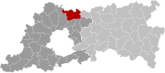 | |
| Coordinates: 50°59′N 04°28′E / 50.983°N 4.467°E | |
| Country | |
| Community | Flemish Community |
| Region | Flemish Region |
| Province | Flemish Brabant |
| Arrondissement | Halle-Vilvoorde |
| Government | |
| • Mayor | Veerle Geerinckx (N-VA) |
| • Governing party/ies | N-VA, VLAM, Groen, Vooruit |
| Area | |
| • Total | 43.23 km2 (16.69 sq mi) |
| Population (2018-01-01)[1] | |
| • Total | 23,325 |
| • Density | 540/km2 (1,400/sq mi) |
| Postal codes | 1980–1982 |
| NIS code | 23096 |
| Area codes | 015, 02, 016 |
| Website | www.zemst.be |

References edit
- ^ "Wettelijke Bevolking per gemeente op 1 januari 2018". Statbel. Retrieved 9 March 2019.
External links edit
 Media related to Zemst at Wikimedia Commons
- Official website – Available only in Dutch