


Summary
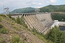
The Zeya Dam is a concrete gravity dam on the Zeya River by the town of Zeya, Amur Oblast, Russia, north of the Chinese border. On average the Zeya Hydroelectric Power Station generates 4.91 TWh of electricity per year. It is equipped with 6 hydro-turbines, 4 with capacity of 225 MW and 2 with capacity of 215 MW.
| Zeya Dam | |
|---|---|
 | |
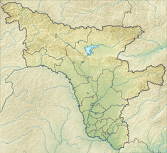 Location of the Zeya Dam in Amur Oblast, Russia | |
| Country | Russia |
| Location | Zeya |
| Coordinates | 53°46′9″N 127°18′23″E / 53.76917°N 127.30639°E |
| Status | Operational |
| Construction began | 1965 |
| Opening date | 1975 |
| Owner(s) | RusHydro |
| Dam and spillways | |
| Impounds | Zeya River |
| Height | 115.5 m (379 ft) |
| Length | 1,284 m (4,213 ft) |
| Spillways | 8 |
| Spillway type | Surface spillway |
| Spillway capacity | 11,104 m3/s (392,134 cu ft/s) |
| Reservoir | |
| Creates | Zeya Reservoir |
| Total capacity | 68.4 km3 (16 cu mi) |
| Surface area | 2,420 km2 (934 sq mi) |
| Maximum length | 225 km (140 mi) |
| Maximum width | 40 km (25 mi) |
| Maximum water depth | 93 m (305 ft) |
| Power Station | |
| Turbines | 4 × 225 MW 2 × 215 MW |
| Installed capacity | 1,330 MW |
The Zeya Reservoir (Russian: Зейское водохранилище) is located in the upper course of the Zeya, below the southern foothills of the Toko-Stanovik, a subrange of the Stanovoy, to the north of the Tukuringra Range and Dzhagdy Range junction.[1] The reservoir is kept at a regulated depth of 93 metres (305 ft). A narrow, 40-kilometre-long (25 mi) valley separates the dam water body from the vast surface of the reservoir. The Baikal-Amur Mainline railway runs along the north shore, where a 1,100-metre-long (3,600 ft) bridge has been constructed.
Settlements on the shore of Zeya Dam include Beregovoy, Khvoyny, Gorny, Verknezeysk, Bomnak and Snezhnogorsk.
See also edit
References edit
External links edit
- Официальный сайт филиала Зейская ГЭС ОАО «РусГидро»
- Официальный сайт ОАО «РусГидро»
- Описание Зейской ГЭС на сайте института Ленгидропроект
- Описание плотины Зейской ГЭС