


Summary
The 1897 Mindanao earthquakes occurred on September 20, 1897, at 19:06 UTC and September 21, 1897, at 05:12 UTC. The estimated epicentres of the two earthquakes are identical, lying just off the southwestern coast of Mindanao in the Philippines, south of Basilan island. The earthquakes were originally given estimated magnitudes of 8.6 and 8.7 on the surface wave magnitude scale by Charles Richter,[1][2] but these were revised downwards by Katsuyuki Abe to 7.4 and 7.5 Ms, respectively.[3] Contemporary reports noted that with few exceptions, all the masonry buildings in Zamboanga and Basilan were left in ruins.[4]
| Local date | September 20, 1897, September 21, 1897 |
|---|---|
| Magnitude | 7.4, 7.5 Ms |
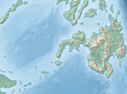
| Epicenter | 6°00′N 122°00′E / 6.0°N 122.0°E |
| Max. intensity | MMI VII (Very strong) MMI IX (Violent) |
| Tsunami | Both |
| Casualties | None reported, 13 to 100+ |

Both earthquakes triggered tsunamis, with the second being quite destructive, with a maximum run-up of 7.0 m.[5] The tsunami was noted all along the southwest coast of Negros, the west coast of Panay, the south coast of Palawan, the west coast of Mindanao, and the east coast of Borneo.[6] At least 13 died as a result of the second tsunami, with a hundred or more casualties also being reported.[2]
See also edit
References edit
- ^ National Geophysical Data Center (1972). "Significant Earthquake Information (20/9)". NCEI/WDS Global Significant Earthquake Database. National Geophysical Data Center/ World Data Service (NGDC/WDS). doi:10.7289/V5TD9V7K. Retrieved August 2, 2022.
- ^ a b National Geophysical Data Center (1972). "Significant Earthquake Information (21/9)". NCEI/WDS Global Significant Earthquake Database. National Geophysical Data Center/ World Data Service (NGDC/WDS). doi:10.7289/V5TD9V7K. Retrieved August 2, 2022.
- ^ Ye L., Lay T. & Kanamori H. (2012). "Intraplate and interplate faulting interactions during the August 31, 2012, Philippine Trench earthquake (M w 7.6) sequence". Geophysical Research Letters. L24310 (24): n/a. Bibcode:2012GeoRL..3924310Y. doi:10.1029/2012GL054164.
- ^ Coronas, José (1899). La actividad séismica en el Archipiélago filipino durante el año 1897 (in Spanish). Manila Observatory: Tipolitografía del Observatorio.
- ^ National Geophysical Data Center. "Tsunami Event Information (21/9)". NGDC/WDS Global Tsunami Event Database. National Geophysical Data Center/ World Data Service. doi:10.7289/V5PN93H7. Retrieved August 2, 2022.
- ^ Saderra Masó, Miguel (1904). Volcanoes and seismic centers of the Philippine Archipelago. Census of the Philippine Islands. Vol. Bulletin 3. Bureau of the Census. pp. 42–44.