


Summary
Alushta City Municipality (Ukrainian: Алуштинська міська рада, Russian: Алуштинский горсовет, Crimean Tatar: Aluşta şeer şurası), officially "the territory governed by the Alushta city council", also known as Greater Alushta is one of the 25 regions of the Autonomous Republic of Crimea, a territory recognized by a majority of countries as part of Ukraine but incorporated by Russia as the Republic of Crimea. Population: 52,318 (2014 Census).[2]
Alushta City Municipality
Алуштинська міська рада | |
|---|---|
 Alushta city council | |
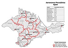
 Location of Alushta municipality in Crimea | |
| Coordinates: 44°40′2″N 34°23′52″E / 44.66722°N 34.39778°E | |
| Country | Territory of Ukraine, occupied by Russia[1] |
| Republic | Crimea |
| Capital | Alushta |
| Subdivisions | List
|
| Area | |
| • Total | 600 km2 (200 sq mi) |
| Population (2014) | |
| • Total | 52,318 |
| • Density | 87/km2 (230/sq mi) |
| Time zone | UTC+3 (MSK) |
| Area code | 380-6560- |
| Website | alushta |
It is a resort region, located at the southern shore of Crimea - one of the most famous recreational territories of the former Soviet Union.
Administrative and municipal status edit
Within the framework of administrative divisions of Russia, Alushta is, together with a number of urban and rural localities, incorporated separately as the town of republican significance of Alushta—an administrative unit with the status equal to that of the districts.[3] As a municipal division, the town of republican significance of Alushta is incorporated as Alushta Urban Okrug.[4]
Within the framework of administrative divisions of Ukraine, Alushta is incorporated as the town of republican significance of Alushta.[5] Ukraine does not have municipal divisions.
Besides the city of Alushta the region includes the town of Partenit and 24 villages which are organized into 6 communities.
Former Crimean Tatar names which were officially changed in 1945-49 and are now used only by the Crimean Tatar community are mentioned in brackets.

|
|
2020 Ukrainian Administrative Reform edit
In July 2020, Ukraine conducted an administrative reform throughout its de jure territory. This included Crimea, which was at the time occupied by Russia, and is still ongoing as of October 2023. Crimea was reorganized from 14 raions and 11 municipalities into 10 raions, with municipalities abolished altogether.
Alushta Municipality was abolished, and its territories to become a part of Yalta Raion, but this has not yet been implemented due to the ongoing Russian occupation.[6]
Sister cities edit
The following cities are twinned with Alushta:[7]
 Äänekoski, Central Finland
 Santa Cruz, California, United States
 Jūrmala, Latvia
 Dzierżoniów, Poland
References edit
- ^ This place is located on the Crimean peninsula, which is internationally recognized as part of Ukraine, but since 2014 under Russian occupation. According to the administrative-territorial division of Ukraine, there are the Ukrainian divisions (the Autonomous Republic of Crimea and the city with special status of Sevastopol) located on the peninsula. Russia claims these as federal subjects of the Russian Federation (the Republic of Crimea and the federal city of Sevastopol).
- ^ Russian Federal State Statistics Service (2014). "Таблица 1.3. Численность населения Крымского федерального округа, городских округов, муниципальных районов, городских и сельских поселений" [Table 1.3. Population of Crimean Federal District, Its Urban Okrugs, Municipal Districts, Urban and Rural Settlements]. Федеральное статистическое наблюдение «Перепись населения в Крымском федеральном округе». ("Population Census in Crimean Federal District" Federal Statistical Examination) (in Russian). Federal State Statistics Service. Retrieved January 4, 2016.
- ^ Law of the Republic of Crimea #35-ZRK
- ^ Law of the Republic of Crimea #15-ZRK
- ^ Чисельність наявного населення України (in Ukrainian). State Service of Statistics. Archived from the original on 1 July 2014. Retrieved 6 May 2014.
- ^ "Про утворення та ліквідацію районів". Офіційний вебпортал парламенту України (in Ukrainian). Retrieved 2023-10-16.
- ^ "Suomen kaupunkiopas" (in Finnish). Kaupunkiopas.com. Retrieved 2015-12-01.