


Summary
Alviela River (Portuguese: Rio Alviela, Portuguese pronunciation: [alviˈɛlɐ]) is a river in Portugal. It is 51.16 kilometres (31.79 mi) long.[3] The Alviela spring is one of the deepest in the world and is locally connected to a cave complex that represents the most significant fluvio-karstic phenomena in Portugal, one which supports several bat colonies with more than 5,000 bats in total.[4] In 2007, a population of troglomorphic Procambarus clarkii, an invasive crayfish species, was recorded in the Alviela spring, raising concerns about their potential effect on native stygobitic fauna. These crayfish lack all body pigment, although pigmented specimens were recorded in nearby surface waters.[5]
| Alviela | |
|---|---|
 | |
| Physical characteristics | |
| Source | |
| • location | Olhos d’Água do Alviela, Alcanena |
| • elevation | 135 m (443 ft) |
| Mouth | Tagus |
• location | near Vale de Figueira[1] |
• elevation | 23 m (75 ft) |
| Length | 51.16 km (31.79 mi) |
| Basin size | 180 km2 (69 sq mi)[2]-331 km2 (128 sq mi)[1] |
| Discharge | |
| • maximum | 17 m3/s (600 cu ft/s)[2] |
| Basin features | |
| Tributaries | Ribeira dos Amiais, Ribeira de Carvalhos, Ribeira da Gouxaria |
| Tagus Basin | |
The river has its origin in a karst spring. Ribeira dos Amiais, a losing stream, infiltrates through the Sumidouro da Ribeira dos Amiais, a ponor, only to return to the surface 250 m further on through a canyon.[6]
-
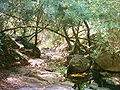 Ribeira dos Amiais, tributary of Alviela
 -
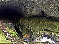 Sumidouro da ribeira dos Amiais, were the water from the stream infiltrates


References edit
- ^ a b "Conhecer o Rio Alviela" (PDF). Retrieved 22 May 2021.
- ^ a b "Nascente dos Olhos de Água do Alviela, Alcanena". www.roteirodeminas.pt (in Portuguese). Retrieved 21 May 2021.
- ^ "Rio Alviela". snirh.inag.pt (in Portuguese). Archived from the original on 2012-01-26. Retrieved 2012-09-22.
- ^ "Mira Minde Polje and related Springs | Ramsar Sites Information Service". rsis.ramsar.org. Retrieved 21 May 2021.
- ^ Mazza, Giuseppe; Sofia, Ana; Reboleira, P.S.; Goncalves, Fernando; Aquiloni, Laura; Inghilesi, Alberto; Spigoli, Daniele; Stoch, Fabio; Taiti, Stefano; Gherardi, Francesca; Tricarico, Elena (2014). "A New Threat to Groundwater Ecosystems: First Occurrences of the Invasive Crayfish Procambarus clarkii (Girard, 1852) in European Caves". Journal of Cave and Karst Studies. 86 (1): 62–65. doi:10.4311/2013LSC0115.
- ^ "Ribeira dos Amiais, um trilho pela perda e ressurgência do PNSAC". Viajar entre Viagens (in European Portuguese). 2020-04-15. Retrieved 22 May 2021.
39°17′40″N 8°36′58″W / 39.29444°N 8.61611°W