


Summary
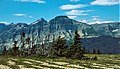
Bear Mountain (8,841 feet (2,695 m)) is located in the northern Lewis Range, Glacier National Park in the U.S. state of Montana.[4] Cosley Lake, followed by Glenns Lake to the southwest of the mountain. Mokowanis Lake is also visible from the peak. The mountain has tremendous views of the east face of Mount Cleveland, the north face of Mount Merritt, and the east face of Chief Mountain.
| Bear Mountain | |
|---|---|
 | |
| Highest point | |
| Elevation | 8,841 ft (2,695 m)[1] |
| Prominence | 841 ft (256 m)[1] |
| Parent peak | Kaina Mountain (9,489 ft)[2] |
| Isolation | 1.86 mi (2.99 km)[2] |
| Coordinates | 48°57′18″N 113°45′27″W / 48.95500°N 113.75750°W[3][3] |
| Geography | |
 Bear Mountain Location in Montana  Bear Mountain Location in the United States | |
| Location | Glacier County, Montana, U.S. |
| Parent range | Lewis Range |
| Topo map | USGS Mount Cleveland |
Climate edit
Bear Mountain is located in an alpine subarctic climate zone characterized by long, usually very cold winters, and short, cool to mild summers.[5] Winter temperatures can drop below −10 °F with wind chill factors below −30 °F.
Geology edit
Like the other mountains in Glacier National Park, Bear Mountain is composed of sedimentary rock laid down during the Precambrian to Jurassic periods. Formed in shallow seas, this sedimentary rock was initially uplifted beginning 170 million years ago when the Lewis Overthrust fault pushed an enormous slab of precambrian rocks 3 mi (4.8 km) thick, 50 miles (80 km) wide and 160 miles (260 km) long over younger rock of the cretaceous period.[6]
Gallery edit
-
 East aspect, with top of parent Kaina Mountain behind left
 -
 East aspect of Bear Mountain (right)
 -
 Bear Mountain, south aspect


See also edit
References edit
- ^ a b "Bear Mountain, Montana". Peakbagger.com. Retrieved May 30, 2018.
- ^ a b "Bear Mountain - 8,841' MT". listsofjohn.com. Retrieved 2021-11-03.
- ^ a b "Bear Mountain". Geographic Names Information System. United States Geological Survey, United States Department of the Interior. Retrieved May 30, 2018.
- ^ Mount Cleveland, MT (Map). TopoQwest (United States Geological Survey Maps). Retrieved May 30, 2018.
- ^ Peel, M. C.; Finlayson, B. L.; McMahon, T. A. (2007). "Updated world map of the Köppen−Geiger climate classification". Hydrol. Earth Syst. Sci. 11 (5): 1633–1644. Bibcode:2007HESS...11.1633P. doi:10.5194/hess-11-1633-2007. ISSN 1027-5606. S2CID 9654551.
- ^ Gadd, Ben (2008). "Geology of the Rocky Mountains and Columbias".
{{cite journal}}: Cite journal requires|journal=(help)