


Summary
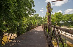
The Bluff Dale Bridge is a historic cable-stayed bridge (not a suspension bridge) located near Bluff Dale, Texas, United States. Built in 1891, the bridge spans 225 feet (69 m) across the Paluxy River. The road deck is 28 feet (8.5 m) above the river and held in place by fourteen 1-inch-diameter (2.5 cm) cables attached to the towers made of 9-inch-diameter (23 cm) iron pipe.[1]
Bluff Dale Suspension Bridge | |
|---|---|
 Bluff Dale Bridge, with the modern bridge that has replaced it for vehicle traffic visible at right. | |
| Coordinates | 32°21′14″N 98°1′34″W / 32.35389°N 98.02611°W |
| Carries | Pedestrian way on County Road 49 (Berry's Creek Road) |
| Crosses | Paluxy River |
| Locale | Berry's Creek Road, Bluff Dale, Texas |
| Owner | Erath County |
| Characteristics | |
| Design | Cable-stayed |
| Material | Wrought iron |
| Total length | 200 feet (61 m) |
| Width | 13 feet (4.0 m) |
| Longest span | 140 feet (43 m) |
| No. of spans | 3 |
| Piers in water | 2 |
| History | |
| Designer | Edwin Elijah Runyon |
| Construction start | 1890 |
| Construction end | 1890 |
Bluff Dale Bridge[a] | |
 Bluff Dale Bridge  Bluff Dale Bridge | |
| Area | 1 acre (0.40 ha) |
| NRHP reference No. | 77001440[2] |
| TSAL No. | 8200000250 |
| Significant dates | |
| Added to NRHP | December 20, 1977 |
| Designated TSAL | May 28, 1981 |
| Location | |
 | |
History edit
The bridge was originally constructed across the river on a dirt road that became Texas State Highway 10, which is now U.S. Route 377. In 1933, a new bridge was built to handle the increasing traffic on U.S. 377. The old bridge was relocated 1.5 miles (2.4 km) upstream in 1934 and extended from 200 to 225 feet (61 to 69 m).[3]
The bridge was added to the National Register of Historic Places on December 20, 1977. The bridge is on Preservation Texas' 2009 list of most endangered places due to its poor condition and lack of funds for restoration. It was closed to vehicular traffic in 1989 because of its advanced state of deterioration.[4]
Structure type edit
Despite the name given in Historic American Engineering Record documentation, the Bluff Dale Suspension Bridge is actually a cable-stayed structure.[5] Its deck is suspended from multiple layers of stay cables radiating from the towers, some terminating at the deck and others running continuously from one tower to the other. This pattern of cables was established in designer Edwin Elijah Runyon's first U.S. patent, US 394,940.[6] It is known as one of only two examples of Runyon's patents, along with the Barton Creek Bridge in Huckabay, Texas. Its hand-twisted wire cable and non-traditional use of wrought-iron pipe components make it a notable example of vernacular American bridge construction.
See also edit
Notes edit
References edit
- ^ a b National Park Service (January 29, 2016), Weekly List of Actions Taken on Properties: 1/19/16 through 1/22/16, archived from the original on January 28, 2016, retrieved January 28, 2016.
- ^ "National Register Information System". National Register of Historic Places. National Park Service. July 9, 2010.
- ^ "Bluff Dale Suspension Bridge". Texas Historic Sites Atlas. Retrieved August 26, 2009.
- ^ "Preservation Texas: Most Endangered Places 2009". Archived from the original on 2009-03-05. Retrieved 2009-05-20.
- ^ Brown, Mark M. (August 1996). "Bluff Dale Suspension Bridge" (PDF). Historic American Engineering Record. Washington, D.C.: Library of Congress. p. 7. Retrieved 2018-10-05.
- ^ Buonopane, Stephen G.; Brown, Mark M. (2003). "History and Engineering Analysis of the 1890 Cable-Stayed Bluff Dale Bridge". Proceedings of the First International Congress on Construction History. Madrid: Instituto Juan de Herrera. pp. 433–442.
External links edit
- Historic American Engineering Record (HAER) No. TX-36, "Bluff Dale Suspension Bridge, Spanning Paluxy River at County Route 149, Bluff Dale, Erath County, TX", 14 photos, 5 measured drawings, 27 data pages, 2 photo caption pages