


Summary
Launceston City Council (or City of Launceston) is a local government body in Tasmania, located in the city and surrounds of Launceston in the north of the state. The Launceston local government area is classified as urban and has a population of 77,363,[1] which also encompasses the localities including Lilydale, Targa and through to Swan Bay on the eastern side of the Tamar River. Launceston has a population growth rate of less than 1%
| Launceston City Council Tasmania | |||||||||||||||
|---|---|---|---|---|---|---|---|---|---|---|---|---|---|---|---|
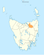
 Map showing the Launceston local government area | |||||||||||||||
| Coordinates | 41°21′38″S 147°18′16″E / 41.3605°S 147.3044°E | ||||||||||||||
| Population | 70,055 (2021)[1] | ||||||||||||||
| • Density | 49.544/km2 (128.32/sq mi) | ||||||||||||||
| Established | 1 January 1853[2] | ||||||||||||||
| Area | 1,414 km2 (545.9 sq mi)[1] | ||||||||||||||
| Mayor | Matthew Garwood | ||||||||||||||
| Council seat | Launceston | ||||||||||||||
| Region | Launceston and surrounds | ||||||||||||||
| State electorate(s) | |||||||||||||||
| Federal division(s) | |||||||||||||||
| Website | Launceston City Council | ||||||||||||||
| |||||||||||||||
Government edit
The current Mayor is Matthew Garwood, elected in 2023.
| Name | Position[3] |
|---|---|
| Matthew Garwood | Mayor/councillor |
| Hugh McKenzie | Deputy mayor/councillor |
| Danny Gibson | Councillor |
| Andrea Dawkins | Councillor |
| Alan Harris | Councillor |
| Tim Walker | Councillor |
| George Razay | Councillor |
| Joe Pentridge | Councillor |
| Andrew Palmer | Councillor |
| Lindi McMahon | Councillo |
| Susie Cai | Councillor |
| Alex Britton | Councillor |
History and attributes edit
Launceston is classified as urban, regional and medium (URM) under the Australian Classification of Local Governments.[4] The population at the 2016 Census was over 65,000, making Launceston the most populous of the 29 local government areas in Tasmania.
The municipality logo features the now extinct Tasmanian tiger, an indigenous marsupial that used to be prevalent in the Launceston district.
History edit
Launceston was first declared as a municipality in 1853 and declared a city in 1888.[5] Its original boundaries have long since been redefined and the area now known as the City of Launceston includes parts of the former Lilydale, St Leonard's, Evandale and Westbury Municipalities.[6] In the 1890s, the municipality grew to include Galvin Town (South Launceston) and in 1906 to include the northern suburbs of Invermay, Mowbray and Trevallyn.[7] This has produced a local government area that overlaps its similarly named city, rather than either being contained by or encompassing it.
Women were ineligible to stand for election to the Launceston City Council until 1945,[8] despite being granted the same rights at federal and state level in 1902 and 1921, respectively.
Localities edit
Suburbs of the city of Launceston edit
• Dilston • East Launceston • Invermay • Kings Meadows • Launceston • Mayfield • Mowbray • Newnham • Newstead • Norwood • Prospect • Punchbowl • Ravenswood • Rocherlea • South Launceston • St Leonards • Summerhill • Trevallyn • Waverley • West Launceston • Youngtown
Localities other than suburbs edit
• Bangor • Blessington • Burns Creek • Golconda • Karoola • Lalla • Lebrina • Lilydale • Lower Turners Marsh • Mount Direction • Myrtle Bank • North Lilydale • Nunamara • Patersonia • Pipers Brook • Pipers River • Prospect Vale • Relbia • Retreat • Springfield • Swan Bay • Targa • Tayene • Tunnel • Turners Marsh • Underwood • Upper Blessington • White Hills • Windermere • Wyena
Sister city relations edit
 – Napa, California, USA
See also edit
References edit
- ^ a b c "2021 Launceston, Census All persons QuickStats | Australian Bureau of Statistics". Australian Bureau of Statistics. Retrieved 23 July 2023. Resident population on census night, 10 August 2021.
- ^ http://www7.austlii.edu.au/cgi-bin/viewdb/au/legis/tas/num_act/aatemcitcohtatol16vn17854/
- ^ "Meet Us - Launceston City". launceston.tas.gov.au. Launceston City Council. Retrieved 22 March 2021.
- ^ "Local government national report 2014-2015". regional.gov.au. Australian Government. Retrieved 8 June 2018.
- ^ History Pages (2007). "Significant works of architects in Launceston". Architecture History of Tasmania. Archived from the original on 30 October 2020.
- ^ "Agency Details: Launceston City Council". search.archives.tas.gov.au. Tasmanian Government. Retrieved 11 June 2018.
- ^ State Library Service of Tasmania (1999). "Properties in Launceston - their owners and occupiers". Retrieved 22 May 2007.
- ^ "Women may be eligible for Council". Launceston Examiner. 14 April 1945.
External links edit
- Launceston City Council official website
- Local Government Association Tasmania Archived 22 June 2018 at the Wayback Machine
- Tasmanian Electoral Commission - local government