


Summary
The City of Swan is a local government area of Western Australia. It is in the eastern metropolitan region of Perth and includes the Swan Valley and 42 suburbs. It is centred approximately 20 km north-east of the Perth central business district. The City covers an area of 1,042 km2 (which is 19.4% of the Perth Metro area) and had an estimated population of 155,653 in 2020.[3]
| City of Swan Western Australia | |||||||||||||||
|---|---|---|---|---|---|---|---|---|---|---|---|---|---|---|---|
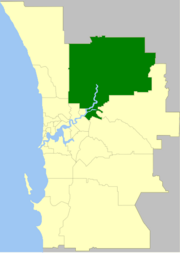 The City of Swan within the Perth Metropolitan Area | |||||||||||||||
 | |||||||||||||||
| Population | 152,974 (LGA 2021)[1] | ||||||||||||||
| Established | 1970 | ||||||||||||||
| Area | 1,042 km2 (402.3 sq mi) | ||||||||||||||
| Mayor | Tanya Richardson[2] | ||||||||||||||
| Council seat | Midland | ||||||||||||||
| Region | Eastern Metropolitan Perth, Swan Valley | ||||||||||||||
| State electorate(s) | Bassendean, Midland, Swan Hills, West Swan, Mirrabooka | ||||||||||||||
| Federal division(s) | Swan, Cowan, Durack, Hasluck, Pearce | ||||||||||||||
 | |||||||||||||||
| Website | City of Swan | ||||||||||||||
| |||||||||||||||
32.7% of the City of Swan population was born overseas, compared with 36.1% for Greater Perth.[4]
The largest non-English speaking country of birth in the City of Swan was India, where 3.1% of the population, or 4,163 people, were born.[4]
History edit
The City of Swan was formed on 20 February 1970 as the Shire of Swan with the amalgamation of the Shire of Swan-Guildford and the Town of Midland. It assumed its current name when it gained city status on 25 April 2000.[5]
On 1 July 2016 the portion of Noranda north of Widgee Road was transferred to the City of Bayswater.[6]
Wards edit
The City of Swan is divided into 5 wards, most of which have three Councillors:[7]
- Altone Ward (3 Councillors)
- Midland/Guildford Ward (3 Councillors)
- Pearce Ward (4 Councillors)
- Swan Valley/Gidgegannup Ward (2 Councillors)
- Whiteman Ward (3 Councillors)
Councillors edit
| Councillor | Ward | Term Expiry | Notes |
|---|---|---|---|
| Haeden Miles | Whiteman | 2023 | |
| Aaron Bowman | Pearce | 2025 | |
| Amanda Dorn | Altone | 2027 | |
| Jagdip Singh | Altone | 2025 | |
| Cate McCullough | Pearce | 2023 | |
| Charlie Zannino | Swan Valley/Gidgegannup | 2025 | |
| Dave Knight | Whiteman | 2025 | |
| Ian Johnson | Midland/Guildford | 2027 | Deputy Mayor |
| Evia Aringo | Pearce | 2027 | |
| Jennifer Catalano | Altone | 2025 | |
| Patty Jones | Pearce | 2025 | |
| Rashelle Predovnik | Midland/Guildford | 2027 | |
| Rod Henderson | Swan Valley/Gidgegannup | 2027 | |
| Sarah Howlett | Midland/Guildford | 2025 | |
| Tanya Richardson | Pearce | 2027 | Mayor |
Suburbs edit
The suburbs of the City of Swan with population and size figures based on the most recent Australian census:[9][10]
| Suburb | Population | Area | Map | ||||||||||||||||||||||||||||||||||||||||||||||||||||||||||||||||||||||||||||||||||||||||||||||||||||||
|---|---|---|---|---|---|---|---|---|---|---|---|---|---|---|---|---|---|---|---|---|---|---|---|---|---|---|---|---|---|---|---|---|---|---|---|---|---|---|---|---|---|---|---|---|---|---|---|---|---|---|---|---|---|---|---|---|---|---|---|---|---|---|---|---|---|---|---|---|---|---|---|---|---|---|---|---|---|---|---|---|---|---|---|---|---|---|---|---|---|---|---|---|---|---|---|---|---|---|---|---|---|---|---|---|---|
| Aveley | 13,998 (SAL 2021)[11] | 6.1 km2 (2.4 sq mi) | 
| ||||||||||||||||||||||||||||||||||||||||||||||||||||||||||||||||||||||||||||||||||||||||||||||||||||||
| Ballajura | 18,459 (SAL 2021)[12] | 8.9 km2 (3.4 sq mi) | 
| ||||||||||||||||||||||||||||||||||||||||||||||||||||||||||||||||||||||||||||||||||||||||||||||||||||||
| Baskerville | 302 (SAL 2021)[13] | 7.7 km2 (3.0 sq mi) | 
| ||||||||||||||||||||||||||||||||||||||||||||||||||||||||||||||||||||||||||||||||||||||||||||||||||||||
| Beechboro | 9,112 (SAL 2021)[14] | 4.9 km2 (1.9 sq mi) | 
| ||||||||||||||||||||||||||||||||||||||||||||||||||||||||||||||||||||||||||||||||||||||||||||||||||||||
| Belhus | 264 (SAL 2021)[15] | 4 km2 (1.5 sq mi) | 
| ||||||||||||||||||||||||||||||||||||||||||||||||||||||||||||||||||||||||||||||||||||||||||||||||||||||
| Bellevue | 1,514 (SAL 2021)[16] | 3 km2 (1.2 sq mi) | 
| ||||||||||||||||||||||||||||||||||||||||||||||||||||||||||||||||||||||||||||||||||||||||||||||||||||||
| Bennett Springs | 5,929 (SAL 2021)[17] | 4.4 km2 (1.7 sq mi) | 
| ||||||||||||||||||||||||||||||||||||||||||||||||||||||||||||||||||||||||||||||||||||||||||||||||||||||
| Brabham | 8,665 (SAL 2021)[18] | 6.5 km2 (2.5 sq mi) | 
| ||||||||||||||||||||||||||||||||||||||||||||||||||||||||||||||||||||||||||||||||||||||||||||||||||||||
| Brigadoon | 1,025 (SAL 2021)[19] | 20 km2 (7.7 sq mi) | 
| ||||||||||||||||||||||||||||||||||||||||||||||||||||||||||||||||||||||||||||||||||||||||||||||||||||||
| Bullsbrook | 5,605 (SAL 2021)[20] | 253.8 km2 (98.0 sq mi) | 
| ||||||||||||||||||||||||||||||||||||||||||||||||||||||||||||||||||||||||||||||||||||||||||||||||||||||
| Bushmead | 677 (SAL 2021)[21] | 3.2 km2 (1.2 sq mi) | 
| ||||||||||||||||||||||||||||||||||||||||||||||||||||||||||||||||||||||||||||||||||||||||||||||||||||||
| Caversham | 7,419 (SAL 2021)[22] | 11.6 km2 (4.5 sq mi) | 
| ||||||||||||||||||||||||||||||||||||||||||||||||||||||||||||||||||||||||||||||||||||||||||||||||||||||
| Cullacabardee | 45 (SAL 2021)[23] | 14.8 km2 (5.7 sq mi) | 
| ||||||||||||||||||||||||||||||||||||||||||||||||||||||||||||||||||||||||||||||||||||||||||||||||||||||
| Dayton | 5,507 (SAL 2021)[24] | 2.8 km2 (1.1 sq mi) | 
| ||||||||||||||||||||||||||||||||||||||||||||||||||||||||||||||||||||||||||||||||||||||||||||||||||||||
| Ellenbrook | 24,668 (SAL 2021)[25] | 13.1 km2 (5.1 sq mi) | 
| ||||||||||||||||||||||||||||||||||||||||||||||||||||||||||||||||||||||||||||||||||||||||||||||||||||||
| Gidgegannup | 2,818 (SAL 2021)[26] | 303.7 km2 (117.3 sq mi) | 
| ||||||||||||||||||||||||||||||||||||||||||||||||||||||||||||||||||||||||||||||||||||||||||||||||||||||
| Guildford | 2,040 (SAL 2021)[27] | 3.2 km2 (1.2 sq mi) | 
| ||||||||||||||||||||||||||||||||||||||||||||||||||||||||||||||||||||||||||||||||||||||||||||||||||||||
| Hazelmere | 935 (SAL 2021)[28] | 7.3 km2 (2.8 sq mi) | 
| ||||||||||||||||||||||||||||||||||||||||||||||||||||||||||||||||||||||||||||||||||||||||||||||||||||||
| Henley Brook | 2,500 (SAL 2021)[29] | 7.3 km2 (2.8 sq mi) | 
| ||||||||||||||||||||||||||||||||||||||||||||||||||||||||||||||||||||||||||||||||||||||||||||||||||||||
| Herne Hill | 1,542 (SAL 2021)[30] | 17.1 km2 (6.6 sq mi) | 
| ||||||||||||||||||||||||||||||||||||||||||||||||||||||||||||||||||||||||||||||||||||||||||||||||||||||
| Jane Brook | 3,670 (SAL 2021)[31] | 5.3 km2 (2.0 sq mi) | 
| ||||||||||||||||||||||||||||||||||||||||||||||||||||||||||||||||||||||||||||||||||||||||||||||||||||||
| Kiara | 1,776 (SAL 2021)[32] | 1.4 km2 (0.54 sq mi) | 
| ||||||||||||||||||||||||||||||||||||||||||||||||||||||||||||||||||||||||||||||||||||||||||||||||||||||
| Koongamia | 985 (SAL 2021)[33] | 0.6 km2 (0.23 sq mi) | 
| ||||||||||||||||||||||||||||||||||||||||||||||||||||||||||||||||||||||||||||||||||||||||||||||||||||||
| Lexia | 30 (SAL 2021)[34] | 25.8 km2 (10.0 sq mi) | 
| ||||||||||||||||||||||||||||||||||||||||||||||||||||||||||||||||||||||||||||||||||||||||||||||||||||||
| Lockridge | 3,322 (SAL 2021)[35] | 1.4 km2 (0.54 sq mi) | 
| ||||||||||||||||||||||||||||||||||||||||||||||||||||||||||||||||||||||||||||||||||||||||||||||||||||||
| Malaga | 25 (SAL 2021)[36] | 6.6 km2 (2.5 sq mi) | 
| ||||||||||||||||||||||||||||||||||||||||||||||||||||||||||||||||||||||||||||||||||||||||||||||||||||||
| Melaleuca | 0 (SAL 2016)[37][38] | 78.8 km2 (30.4 sq mi) | 
| ||||||||||||||||||||||||||||||||||||||||||||||||||||||||||||||||||||||||||||||||||||||||||||||||||||||
| Middle Swan | 2,852 (SAL 2021)[39] | 12.8 km2 (4.9 sq mi) | 
| ||||||||||||||||||||||||||||||||||||||||||||||||||||||||||||||||||||||||||||||||||||||||||||||||||||||
| Midland | 6,335 (SAL 2021)[40] | 4.4 km2 (1.7 sq mi) | 
| ||||||||||||||||||||||||||||||||||||||||||||||||||||||||||||||||||||||||||||||||||||||||||||||||||||||
| Midvale | 2,283 (SAL 2021)[41] | 2.9 km2 (1.1 sq mi) | 
| ||||||||||||||||||||||||||||||||||||||||||||||||||||||||||||||||||||||||||||||||||||||||||||||||||||||
| Millendon | 490 (SAL 2021)[42] | 6.9 km2 (2.7 sq mi) | 
| ||||||||||||||||||||||||||||||||||||||||||||||||||||||||||||||||||||||||||||||||||||||||||||||||||||||
| Perth Airport * | 25 (SAL 2021)[43] | 19.2 km2 (7.4 sq mi) | 
| ||||||||||||||||||||||||||||||||||||||||||||||||||||||||||||||||||||||||||||||||||||||||||||||||||||||
| Red Hill | 85 (SAL 2021)[44] | 15.7 km2 (6.1 sq mi) | 
| ||||||||||||||||||||||||||||||||||||||||||||||||||||||||||||||||||||||||||||||||||||||||||||||||||||||
| South Guildford | 3,781 (SAL 2021)[45] | 5.8 km2 (2.2 sq mi) | 
| ||||||||||||||||||||||||||||||||||||||||||||||||||||||||||||||||||||||||||||||||||||||||||||||||||||||
| Stratton | 3,267 (SAL 2021)[46] | 2.3 km2 (0.89 sq mi) | 
| ||||||||||||||||||||||||||||||||||||||||||||||||||||||||||||||||||||||||||||||||||||||||||||||||||||||
| Swan View | 7,889 (SAL 2021)[47] | 7.5 km2 (2.9 sq mi) | 
| ||||||||||||||||||||||||||||||||||||||||||||||||||||||||||||||||||||||||||||||||||||||||||||||||||||||
| The Vines | 5,848 (SAL 2021)[48] | 6.6 km2 (2.5 sq mi) | 
| ||||||||||||||||||||||||||||||||||||||||||||||||||||||||||||||||||||||||||||||||||||||||||||||||||||||
| Upper Swan | 549 (SAL 2021)[49] | 19.8 km2 (7.6 sq mi) | 
| ||||||||||||||||||||||||||||||||||||||||||||||||||||||||||||||||||||||||||||||||||||||||||||||||||||||
| Viveash | 1,280 (SAL 2021)[50] | 2.1 km2 (0.81 sq mi) | 
| ||||||||||||||||||||||||||||||||||||||||||||||||||||||||||||||||||||||||||||||||||||||||||||||||||||||
| West Swan | 786 (SAL 2021)[51] | 6.6 km2 (2.5 sq mi) | 
| ||||||||||||||||||||||||||||||||||||||||||||||||||||||||||||||||||||||||||||||||||||||||||||||||||||||
| Whiteman | 10 (SAL 2021)[52] | 27.7 km2 (10.7 sq mi) | 
| ||||||||||||||||||||||||||||||||||||||||||||||||||||||||||||||||||||||||||||||||||||||||||||||||||||||
| Woodbridge | 1,207 (SAL 2021)[53] | 1.4 km2 (0.54 sq mi) |
( * indicates suburb partially located within City)
Population
edit
 Population of antecedent councils edit
Population of the unified City of Swan edit
Heritage-listed places editAs of 2024[update], 676 places are heritage-listed in the City of Swan,[54] of which 317 are on the State Register of Heritage Places, among them the Garrick Theatre, Guildford Grammar School Chapel and the Midland Railway Workshops.[55] References edit
External links edit
31°53′42″S 115°59′35″E / 31.895°S 115.993°E | ||||||||||||||||||||||||||||||||||||||||||||||||||||||||||||||||||||||||||||||||||||||||||||||||||||||