


Summary
The Cloquet River is a 104-mile-long (167 km)[1] river in Minnesota, United States. It is the main tributary of the Saint Louis River.[2]
| Cloquet River | |
|---|---|
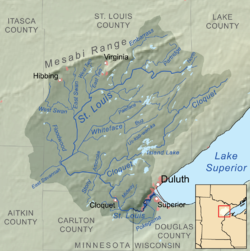 Map of the Saint Louis River drainage basin showing the Cloquet River | |
 Mouth of the Cloquet River | |
| Location | |
| Country | United States |
| State | Minnesota |
| Counties | Lake, St. Louis |
| Physical characteristics | |
| Source | |
| • location | Cloquet Lake, Silver Creek Township, Lake County, Minnesota |
| • coordinates | 47°25′53″N 91°29′12″W / 47.4313058°N 91.4865513°W |
| Mouth | |
• location | Saint Louis River at Culver Township, St. Louis County, Minnesota |
• coordinates | 46°51′41″N 92°34′13″W / 46.86139°N 92.57028°W |
| Length | 104 miles (167 km) |
| Basin features | |
| Progression | Cloquet River→ Saint Louis River→ Lake Superior |
Name edit
Cloquet (/kloʊˈkeɪ/ ⓘ kloh-KAY) River is known in the Ojibwe language as the Gaa-biitootigweyaag-ziibi ("River that parallels the Saint Louis River"). On the map of Stephen H. Long's expedition in 1823, it shows that stream as "Rapid River", and it is unnamed on the map by David Thompson in 1826 for the proposed routes of the international boundary. However, on the 1843 Joseph N. Nicollet map, the river is identified by its present name.[3]
Geography edit
The Cloquet River generally flows in a southwesterly direction through Indian Lake, Alden Lake, and Island Lake, before emptying into the Saint Louis River.
One can separate the river into two primary stretches, the upper stretch beginning at Cloquet Lake in Lake County as a small stream and ending at Island Lake.
Tributaries of the Cloquet River include the Us-kab-wan-ka River, the Beaver River, and Little Cloquet River.
See also edit
References edit
- ^ "National Hydrography Dataset high-resolution flowline data". U.S. Geological Survey. Archived from the original on 2012-03-29. Retrieved 2012-09-28., accessed May 7, 2012
- ^ U.S. Geological Survey Geographic Names Information System: Cloquet River
- ^ Upham, Warren. "Cloquet"[permanent dead link] in "Carlton County" section of Minnesota Place Names: A Geographical Encyclopedia. Accessed July 27, 2013.
- Minnesota Watersheds
- USGS Hydrologic Unit Map - State of Minnesota (1974)