


Summary
Georgetown is a rural town and locality in the Shire of Etheridge, Queensland, Australia.[3][4] In the 2016 census, the locality of Georgetown had a population of 348 people.[1]
| Georgetown Queensland | |||||||||||||||
|---|---|---|---|---|---|---|---|---|---|---|---|---|---|---|---|
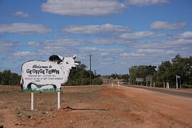 Entry into Georgetown | |||||||||||||||
 Georgetown | |||||||||||||||
| Coordinates | 18°17′32″S 143°32′53″E / 18.2922°S 143.5480°E | ||||||||||||||
| Population | 348 (2016 census)[1] | ||||||||||||||
| • Density | 0.07956/km2 (0.20607/sq mi) | ||||||||||||||
| Postcode(s) | 4871 | ||||||||||||||
| Elevation | 292 m (958 ft)[2] | ||||||||||||||
| Area | 4,373.9 km2 (1,688.8 sq mi) | ||||||||||||||
| Time zone | AEST (UTC+10:00) | ||||||||||||||
| Location |
| ||||||||||||||
| LGA(s) | Shire of Etheridge | ||||||||||||||
| County | Gilbert County | ||||||||||||||
| State electorate(s) | Traeger | ||||||||||||||
| Federal division(s) | Kennedy | ||||||||||||||
| |||||||||||||||
| |||||||||||||||
History edit
Georgetown area may have been part of North America 1.7 billion years ago based on the characteristics of rocks found in Georgetown matching those of northern Canada rather than the rest of Australia. Researchers at Curtin University have postulated that 100 million years later, this landmass collided with what is now northern Australia, at the Mount Isa region, forming the Nuna supercontinent.[5]
Georgetown was on the northern border of Ewamin lands.
The Etheridge River was the site of a gold rush in the 1870s; the town of Georgetown was established on the site of the diggings. Originally known by the name Etheridge, the town's name was changed in 1871 to honour an early gold commissioner, Howard St George.[6] Georgetown Post Office opened on 15 January 1872.[7]
Georgetown State School opened on 14 September 1874.[8]
As in many places around Australia associated with gold, Chinese miners also prospected and this included one or possibly two Joss Houses. " "John" is keeping the high festival of the new year, and wakes the silent watches of the night by crackers and uncouth devices of fire. Here he has a Joss-house, with a gaudy standard floating in front.” [9]
“GEORGETOWN January 20. Extensive preparations are being made by the Chinese residents for the opening of the Joss House. Lim Chee, an ancient Chinese priest, conducts the ceremony known as "Yosshima."[10]
By 1900, grazing had replaced gold mining as the region's primary source of income.
The Georgetown Public Library opened in 2003.[11]
In the 2006 census, Georgetown had a population of 254.[12]
In the 2011 census, the locality of Georgetown had a population of 243 people.[13]
In the 2016 census, the locality of Georgetown had a population of 348 people.[1]
Geography edit
Georgetown is on the Etheridge River in Far North Queensland, Australia. The Gulf Developmental Road passes through the town, linking Cairns - 380 kilometres (240 mi) to the east - and Normanton - 301 kilometres (187 mi) to the west. Georgetown is the administrative headquarters of the Shire of Etheridge, a local government area encompassing the nearby settlements of Mount Surprise, Forsayth and Einasleigh.
Climate edit
Georgetown has a borderline tropical savanna climate (Köppen Aw) bordering on a hot semi-arid climate (BSh). The wet season from mid-November to March is hot and humid with like all of tropical Queensland highly erratic rainfall.[14] During the wet season, rainfall is highly concentrated into a few days from monsoonal depressions or remnant cyclones.[15] Wet season weather can vary from daily thunderstorm rains in active monsoon months like January and February 1974 when rain fell on fifty-five consecutive days and 2,072 millimetres (81.57 in) fell between December and March, to long sweltering and dry spells as in 1925/1926, when only 232.5 millimetres or 9.15 inches fell during those four months. The dry season from April to mid-November is very warm, becoming sweltering in the “build-up” to the wet season during October and November and almost completely dry. Nevertheless, the height of the dry season features cool to pleasant mornings more typical of the humid subtropical climate areas to the southeast, and Georgetown is amongst the most northerly locations in Australia to record frost, with the temperature falling as low as −3.0 °C (26.6 °F) on 9 July 1974.
| Climate data for Georgetown | |||||||||||||
|---|---|---|---|---|---|---|---|---|---|---|---|---|---|
| Month | Jan | Feb | Mar | Apr | May | Jun | Jul | Aug | Sep | Oct | Nov | Dec | Year |
| Record high °C (°F) | 43.5 (110.3) |
41.0 (105.8) |
39.2 (102.6) |
38.3 (100.9) |
36.8 (98.2) |
34.8 (94.6) |
35.4 (95.7) |
37.0 (98.6) |
39.5 (103.1) |
42.6 (108.7) |
43.3 (109.9) |
43.5 (110.3) |
43.5 (110.3) |
| Mean daily maximum °C (°F) | 34.4 (93.9) |
33.5 (92.3) |
33.4 (92.1) |
32.5 (90.5) |
30.4 (86.7) |
28.2 (82.8) |
28.2 (82.8) |
30.0 (86.0) |
33.0 (91.4) |
35.8 (96.4) |
36.6 (97.9) |
36.1 (97.0) |
32.7 (90.9) |
| Mean daily minimum °C (°F) | 22.9 (73.2) |
22.7 (72.9) |
21.5 (70.7) |
19.4 (66.9) |
16.1 (61.0) |
13.1 (55.6) |
12.0 (53.6) |
13.1 (55.6) |
16.2 (61.2) |
19.7 (67.5) |
21.7 (71.1) |
22.8 (73.0) |
18.4 (65.1) |
| Record low °C (°F) | 10.6 (51.1) |
15.1 (59.2) |
11.1 (52.0) |
5.0 (41.0) |
2.2 (36.0) |
−0.6 (30.9) |
−3.0 (26.6) |
−1.1 (30.0) |
2.2 (36.0) |
6.7 (44.1) |
8.9 (48.0) |
11.1 (52.0) |
−3.0 (26.6) |
| Average rainfall mm (inches) | 224.9 (8.85) |
212.9 (8.38) |
123.1 (4.85) |
28.8 (1.13) |
9.3 (0.37) |
10.4 (0.41) |
6.7 (0.26) |
4.3 (0.17) |
6.4 (0.25) |
16.7 (0.66) |
50.7 (2.00) |
127.8 (5.03) |
822 (32.36) |
| Average rainy days (≥ 0.2 mm) | 13.7 | 12.9 | 8.3 | 2.7 | 1.2 | 1.2 | 0.8 | 0.4 | 0.7 | 2.0 | 5.3 | 9.5 | 58.7 |
| Source: Bureau of Meteorology[16] | |||||||||||||
Heritage listings edit
Georgetown has a number of heritage-listed sites, including:
- Gulf Developmental Road: Aspasia Mine and Battery[17]
- South Street: Antbed House[18]
Education edit
Georgetown State School is a government primary (Early Childhood to Year 6) school for boys and girls at High Street (18°17′41″S 143°32′50″E / 18.2947°S 143.5473°E).[19][20] In 2014, Georgetown State School had an enrolment of 57 students with 3 teachers.[21] In 2018, the school had an enrolment of 42 students with 4 teachers (3 full-time equivalent) and 7 non-teaching staff (4 full-time equivalent).[22]
There are no secondary schools in Georgetown, nor nearby. The options are distance education and boarding school.[23]
Facilities edit
Georgetown has a racecourse, swimming pool and a tourist information centre and camping/caravan park.[24]
The Etheridge Shire Council operates a public library at Low Street, Georgetown.[25]
The Georgetown branch of the Queensland Country Women's Association has its rooms on the Gulf Developmental Road.[26]
The Terrestrial Information Centre contains the Ted Elliot Mineral Collection, comprising over 4500 local and international mineral specimens.[27]
St Patrick's Catholic Church is at 26 High Street. It is within the Gulf Savannah Parish of the Roman Catholic Diocese of Cairns.[28]
In popular culture edit
Georgetown is one of the real locations mentioned several times in the novel A Town Like Alice by Nevil Shute.
References edit
- ^ a b c Australian Bureau of Statistics (27 June 2017). "Georgetown (SSC)". 2016 Census QuickStats. Retrieved 20 October 2018.
- ^ Bureau of Meteorology
- ^ "Georgetown – town in Shire of Etheridge (entry 13605)". Queensland Place Names. Queensland Government. Retrieved 14 August 2022.
- ^ "Georgetown – locality in Shire of Etheridge (entry 47872)". Queensland Place Names. Queensland Government. Retrieved 14 August 2022.
- ^ "Curtin researchers discover a piece of America in northern Australia". Curtin University. Archived from the original on 23 January 2018. Retrieved 23 January 2018.
- ^ "Georgetown (entry 13605)". Queensland Place Names. Queensland Government. Retrieved 13 September 2015.
- ^ Premier Postal History. "Post Office List". Premier Postal Auctions. Retrieved 10 May 2014.
- ^ Queensland Family History Society (2010), Queensland schools past and present (Version 1.01 ed.), Queensland Family History Society, ISBN 978-1-921171-26-0
- ^ "Joss House". The Queenslander, 20 March 1880, p.372.
- ^ "Joss House". The North Queensland Register, 23 January 1905, p.6.
- ^ "Public Libraries Statistical Bulletin 2016-17" (PDF). Public Libraries Connect. State Library of Queensland. November 2017. p. 12. Retrieved 24 January 2018.
- ^ Australian Bureau of Statistics (25 October 2007). "Georgetown (L) (Urban Centre/Locality)". 2006 Census QuickStats. Retrieved 28 October 2007.
- ^ Australian Bureau of Statistics (31 October 2012). "Georgetown (SSC)". 2011 Census QuickStats. Retrieved 27 June 2016.
- ^ Dewar, Robert E. and Wallis, James R; ‘Geographical patterning of interannual rainfall variability in the tropics and near tropics: An L-moments approach’; in Journal of Climate, 12; pp. 3457-3466
- ^ Jackson, I.J. (1988). "Daily Rainfall over Northern Australia: Deviations from the World Pattern". Journal of Climatology. 8 (5): 463–476. doi:10.1002/joc.3370080503.
- ^ "Climate statistics for Georgetown". Bureau of Meteorology.
- ^ "Aspasia Mine and Battery (entry 602245)". Queensland Heritage Register. Queensland Heritage Council. Retrieved 7 July 2013.
- ^ "Antbed House (entry 601628)". Queensland Heritage Register. Queensland Heritage Council. Retrieved 7 July 2013.
- ^ "State and non-state school details". Queensland Government. 9 July 2018. Archived from the original on 21 November 2018. Retrieved 21 November 2018.
- ^ "Georgetown State School". Retrieved 21 November 2018.
- ^ "2014 School Annual Report". Georgetown State School. Retrieved 27 June 2016.
- ^ "ACARA School Profile 2018". Australian Curriculum, Assessment and Reporting Authority. Retrieved 28 January 2020.
- ^ "Queensland Globe". State of Queensland. Retrieved 25 August 2022.
- ^ "Georgetown". Centre for the Government of Queensland. Retrieved 21 December 2011.
- ^ "Georgetown Library". Public Libraries Connect. State Library of Queensland. 2 November 2015. Retrieved 24 January 2018.
- ^ "Branch locations". Queensland Country Women's Association. Archived from the original on 26 December 2018. Retrieved 26 December 2018.
- ^ Etheridge. "Terrestrial Information Centre - Etheridge". www.etheridge.qld.gov.au. Retrieved 18 February 2018.
- ^ "Gulf Savannah Parish". Roman Catholic Diocese of Cairns. Archived from the original on 18 November 2020. Retrieved 18 November 2020.
External links edit
- University of Queensland: Queensland Places: Georgetown
- Etheridge Shire Council
- Town information
- Town map, 1983
- 1.7-Billion-Year-Old Chunk of North America Found Sticking to Australia