


Summary
Gigaquit, officially the Municipality of Gigaquit (Surigaonon: Lungsod nan Gigaquit; Tagalog: Bayan ng Gigaquit), is a 4th class municipality in the province of Surigao del Norte, Philippines. According to the 2020 census, it has a population of 21,849 people.[3]
Gigaquit | |
|---|---|
| Municipality of Gigaquit | |
 Flag | |
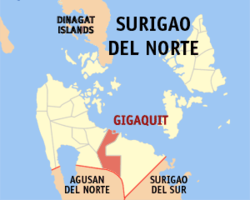 Map of Surigao del Norte with Gigaquit highlighted | |
OpenStreetMap .mw-parser-output .locmap .od{position:absolute}.mw-parser-output .locmap .id{position:absolute;line-height:0}.mw-parser-output .locmap .l0{font-size:0;position:absolute}.mw-parser-output .locmap .pv{line-height:110%;position:absolute;text-align:center}.mw-parser-output .locmap .pl{line-height:110%;position:absolute;top:-0.75em;text-align:right}.mw-parser-output .locmap .pr{line-height:110%;position:absolute;top:-0.75em;text-align:left}.mw-parser-output .locmap .pv>div{display:inline;padding:1px}.mw-parser-output .locmap .pl>div{display:inline;padding:1px;float:right}.mw-parser-output .locmap .pr>div{display:inline;padding:1px;float:left}html.skin-theme-clientpref-night .mw-parser-output .od,html.skin-theme-clientpref-night .mw-parser-output .od .pv>div,html.skin-theme-clientpref-night .mw-parser-output .od .pl>div,html.skin-theme-clientpref-night .mw-parser-output .od .pr>div{background:#000;color:#fff}html.skin-theme-clientpref-night .mw-parser-output .locmap{filter:grayscale(0.6)}@media(prefers-color-scheme:dark){html.skin-theme-clientpref-os .mw-parser-output .locmap{filter:grayscale(0.6)}html.skin-theme-clientpref-os .mw-parser-output .od,html.skin-theme-clientpref-os .mw-parser-output .od .pv>div,html.skin-theme-clientpref-os .mw-parser-output .od .pl>div,html.skin-theme-clientpref-os .mw-parser-output .od .pr>div{background:#000;color:#fff}}  Gigaquit Location within the Philippines | |
| Coordinates: 9°35′41″N 125°41′51″E / 9.5947°N 125.6975°E | |
| Country | Philippines |
| Region | Caraga |
| Province | Surigao del Norte |
| District | 2nd district |
| Founded | 1850 |
| Barangays | 13 (see Barangays) |
| Government | |
| • Type | Sangguniang Bayan |
| • Mayor | Chandru T. Bonite |
| • Vice Mayor | Jennifer B. Bonite |
| • Representative | Robert Ace S. Barbers |
| • Municipal Council | Members |
| • Electorate | 15,425 voters (2022) |
| Area | |
| • Total | 138.11 km2 (53.32 sq mi) |
| Elevation | 10 m (30 ft) |
| Highest elevation | 222 m (728 ft) |
| Lowest elevation | 0 m (0 ft) |
| Population (2020 census)[3] | |
| • Total | 21,849 |
| • Density | 160/km2 (410/sq mi) |
| • Households | 5,229 |
| Economy | |
| • Income class | 4th municipal income class |
| • Poverty incidence | 39.23 |
| • Revenue | ₱ 108.4 million (2020) |
| • Assets | ₱ 293.9 million (2020) |
| • Expenditure | ₱ 128.9 million (2020) |
| • Liabilities | ₱ 130.4 million (2020) |
| Service provider | |
| • Electricity | Surigao del Norte Electric Cooperative (SURNECO) |
| Time zone | UTC+8 (PST) |
| ZIP code | 8409 |
| PSGC | 166711000 |
| IDD : area code | +63 (0)86 |
| Native languages | Surigaonon Agusan Cebuano Tagalog |
| Website | www |
The name is derived from the words gigad (meaning "shore") and gakit (meaning "bamboo raft") and refers to the means of transportation that the early settlers used to travel from the inland to the shore.[5]
History edit
Gigaquit was established in 1850 by Cero, a native who fortified the place to make it safe from Moro raiders. During this period, the local population was Christianized by priests from religious orders who made Saint Augustine their patron saint.[5]
Bacuag and Claver, which had been part of Gigaquit, became separate municipalities in 1918 and 1955 under Executive Order Nos. 61 and 126 respectively.[5]
Geography edit
Barangays edit
Gigaquit is politically subdivided into 13 barangays. Each barangay consists of puroks while some have sitios.
- Alambique (Poblacion)
- Anibongan
- Cam-boayon
- Camam-onan
- Ipil (Poblacion)
- Lahi
- Mahanub
- Poniente
- San Antonio (Bonot)
- San Isidro (Parang)
- Sico-sico
- Villaflor
- Villafranca
Climate edit
| Climate data for Gigaquit, Surigao del Norte | |||||||||||||
|---|---|---|---|---|---|---|---|---|---|---|---|---|---|
| Month | Jan | Feb | Mar | Apr | May | Jun | Jul | Aug | Sep | Oct | Nov | Dec | Year |
| Mean daily maximum °C (°F) | 27 (81) |
28 (82) |
28 (82) |
30 (86) |
30 (86) |
30 (86) |
29 (84) |
30 (86) |
30 (86) |
29 (84) |
29 (84) |
28 (82) |
29 (84) |
| Mean daily minimum °C (°F) | 23 (73) |
23 (73) |
23 (73) |
23 (73) |
25 (77) |
25 (77) |
25 (77) |
25 (77) |
25 (77) |
25 (77) |
24 (75) |
24 (75) |
24 (75) |
| Average precipitation mm (inches) | 210 (8.3) |
161 (6.3) |
123 (4.8) |
85 (3.3) |
148 (5.8) |
186 (7.3) |
164 (6.5) |
157 (6.2) |
141 (5.6) |
190 (7.5) |
223 (8.8) |
200 (7.9) |
1,988 (78.3) |
| Average rainy days | 21.0 | 16.8 | 18.5 | 18.2 | 24.9 | 27.7 | 28.4 | 27.0 | 26.1 | 27.6 | 24.6 | 22.0 | 282.8 |
| Source: Meteoblue[6] | |||||||||||||
Demographics edit
| Year | Pop. | ±% p.a. |
|---|---|---|
| 1903 | 5,290 | — |
| 1918 | 14,244 | +6.83% |
| 1939 | 13,676 | −0.19% |
| 1948 | 14,431 | +0.60% |
| 1960 | 8,368 | −4.44% |
| 1970 | 11,097 | +2.86% |
| 1975 | 11,810 | +1.26% |
| 1980 | 13,186 | +2.23% |
| 1990 | 13,715 | +0.39% |
| 1995 | 15,261 | +2.02% |
| 2000 | 16,155 | +1.23% |
| 2007 | 18,870 | +2.17% |
| 2010 | 18,784 | −0.17% |
| 2015 | 20,864 | +2.02% |
| 2020 | 21,849 | +0.91% |
| Source: Philippine Statistics Authority[7][8][9][10] | ||
Economy edit
References edit
- ^ Municipality of Gigaquit | (DILG)
- ^ "2015 Census of Population, Report No. 3 – Population, Land Area, and Population Density" (PDF). Philippine Statistics Authority. Quezon City, Philippines. August 2016. ISSN 0117-1453. Archived (PDF) from the original on May 25, 2021. Retrieved July 16, 2021.
- ^ a b Census of Population (2020). "Caraga". Total Population by Province, City, Municipality and Barangay. Philippine Statistics Authority. Retrieved July 8, 2021.
- ^ "PSA Releases the 2018 Municipal and City Level Poverty Estimates". Philippine Statistics Authority. December 15, 2021. Retrieved January 22, 2022.
- ^ a b c "Historical Background". Gigaquit. Province of Surigao Del Norte. Archived from the original on August 20, 2013. Retrieved August 29, 2013.
- ^ "Gigaquit: Average Temperatures and Rainfall". Meteoblue. Retrieved November 20, 2019.
- ^ Census of Population (2015). "Caraga". Total Population by Province, City, Municipality and Barangay. Philippine Statistics Authority. Retrieved June 20, 2016.
- ^ Census of Population and Housing (2010). "Caraga" (PDF). Total Population by Province, City, Municipality and Barangay. National Statistics Office. Retrieved June 29, 2016.
- ^ Censuses of Population (1903–2007). "Caraga". Table 1. Population Enumerated in Various Censuses by Province/Highly Urbanized City: 1903 to 2007. National Statistics Office.
{{cite encyclopedia}}: CS1 maint: numeric names: authors list (link) - ^ "Province of Surigao del Norte". Municipality Population Data. Local Water Utilities Administration Research Division. Retrieved December 17, 2016.
- ^ "Poverty incidence (PI):". Philippine Statistics Authority. Retrieved December 28, 2020.
- ^ "Estimation of Local Poverty in the Philippines" (PDF). Philippine Statistics Authority. November 29, 2005.
- ^ "2003 City and Municipal Level Poverty Estimates" (PDF). Philippine Statistics Authority. March 23, 2009.
- ^ "City and Municipal Level Poverty Estimates; 2006 and 2009" (PDF). Philippine Statistics Authority. August 3, 2012.
- ^ "2012 Municipal and City Level Poverty Estimates" (PDF). Philippine Statistics Authority. May 31, 2016.
- ^ "Municipal and City Level Small Area Poverty Estimates; 2009, 2012 and 2015". Philippine Statistics Authority. July 10, 2019.
- ^ "PSA Releases the 2018 Municipal and City Level Poverty Estimates". Philippine Statistics Authority. December 15, 2021. Retrieved January 22, 2022.
External links edit
- Gigaquit Profile at PhilAtlas.com
- Gigaquit Profile at the DTI Cities and Municipalities Competitive Index
- Philippine Standard Geographic Code
- Philippine Census Information
- Local Governance Performance Management System Archived March 4, 2016, at the Wayback Machine