


Summary
Gornozavodsky District (Russian: Горнозаво́дский райо́н) is an administrative district (raion) of Perm Krai, Russia; one of the thirty-three in the krai.[1] Municipally, it is incorporated as Gornozavodsky Municipal District.[6] It is located on the western slopes of the Ural Mountains in the east of the krai. The area of the district is 7,057 square kilometers (2,725 sq mi).[2] Its administrative center is the town of Gornozavodsk.[1] Population: 26,044 (2010 Russian census);[3] 30,172 (2002 Census);[8] 38,004 (1989 Soviet census).[9] The population of Gornozavodsk accounts for 46.3% of the district's total population.[3]
Gornozavodsky District
Горнозаводский район | |
|---|---|
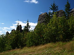 Rock formations, Kolpaki, Gornozavodsky District | |
 Flag  Coat of arms | |
 Location of Gornozavodsky District in Perm Krai | |
| Coordinates: 58°35′02″N 57°32′42″E / 58.584°N 57.545°E | |
| Country | Russia |
| Federal subject | Perm Krai[1] |
| Established | November 4, 1965[2] |
| Administrative center | Gornozavodsk[1] |
| Area | |
| • Total | 7,057 km2 (2,725 sq mi) |
| Population | |
| • Total | 26,044 |
| • Estimate (2018)[4] | 23,634 (−9.3%) |
| • Density | 3.7/km2 (9.6/sq mi) |
| • Urban | 94.4% |
| • Rural | 5.6% |
| Administrative structure | |
| • Inhabited localities[1] | 1 cities/towns, 1 Urban-type settlements[5], 9 rural localities |
| Municipal structure | |
| • Municipally incorporated as | Gornozavodsky Municipal District[6] |
| • Municipal divisions[6] | 1 urban settlements, 6 rural settlements |
| Time zone | UTC+5 (MSK+2 |
| OKTMO ID | 57614000 |
| Website | http://www.gornozavodskii.ru/ |
Geography edit
The landscape of the district is hilly in the west and mountainous in the east. Climate changes from southwest to northeast, where it becomes more cold and humid. Main rivers include the Vilva, the Vizhay, the Koyva, and the Usva.
A part of the Basegi Nature Reserve occupies the north of the district.
History edit
Human settlement of this territory started in the early 17th century, when iron ore was found. Several metallurgical plants were later constructed. In the end of the 19th century, the Perm–Yekaterinburg was constructed, contributing to the development of the region. The district in its modern borders was established on November 4, 1965, when it was split from Chusovskoy District.[2]
Demographics edit
Most of the inhabited localities in the district are concentrated along the Perm-Nizhny Tagil railroad and along the Koyva River.
Ethnically, Russians account for 88.4% of the population, Tatars are distant second at 4.9%, followed by Ukrainians at 1.7%.[2]
Economy edit
Timber and metallurgical industries and manufacture of building materials form the basis of the district's economy.[citation needed]
References edit
Notes edit
- ^ a b c d e Law #416-67
- ^ a b c d e Encyclopedia of Perm Krai. Entry on Gornozavodsky District (in Russian)
- ^ a b c Russian Federal State Statistics Service (2011). Всероссийская перепись населения 2010 года. Том 1 [2010 All-Russian Population Census, vol. 1]. Всероссийская перепись населения 2010 года [2010 All-Russia Population Census] (in Russian). Federal State Statistics Service.
- ^ "26. Численность постоянного населения Российской Федерации по муниципальным образованиям на 1 января 2018 года". Federal State Statistics Service. Retrieved January 23, 2019.
- ^ The count of urban-type settlements may include the work settlements, the resort settlements, the suburban (dacha) settlements, as well as urban-type settlements proper.
- ^ a b c Law #1733-354
- ^ "Об исчислении времени". Официальный интернет-портал правовой информации (in Russian). June 3, 2011. Retrieved January 19, 2019.
- ^ Federal State Statistics Service (May 21, 2004). Численность населения России, субъектов Российской Федерации в составе федеральных округов, районов, городских поселений, сельских населённых пунктов – районных центров и сельских населённых пунктов с населением 3 тысячи и более человек [Population of Russia, Its Federal Districts, Federal Subjects, Districts, Urban Localities, Rural Localities—Administrative Centers, and Rural Localities with Population of Over 3,000] (XLS). Всероссийская перепись населения 2002 года [All-Russia Population Census of 2002] (in Russian).
- ^ Всесоюзная перепись населения 1989 г. Численность наличного населения союзных и автономных республик, автономных областей и округов, краёв, областей, районов, городских поселений и сёл-райцентров [All Union Population Census of 1989: Present Population of Union and Autonomous Republics, Autonomous Oblasts and Okrugs, Krais, Oblasts, Districts, Urban Settlements, and Villages Serving as District Administrative Centers]. Всесоюзная перепись населения 1989 года [All-Union Population Census of 1989] (in Russian). Институт демографии Национального исследовательского университета: Высшая школа экономики [Institute of Demography at the National Research University: Higher School of Economics]. 1989 – via Demoscope Weekly.
Sources edit
- Законодательное собрание Пермской области. Закон №416-67 от 28 февраля 1996 г. «Об административно-территориальном устройстве Пермского края», в ред. Закона №504-ПК от 9 июля 2015 г. «О внесении изменений в Закон Пермской области "Об административно-территориальном устройстве Пермского края"». Вступил в силу с момента опубликования. Опубликован: "Звезда", №38, 12 марта 1996 г. (Legislative Assembly of Perm Oblast. Law #416-67 of February 28, 1996 On the Administrative-Territorial Structure of Perm Krai, as amended by the Law #504-PK of July 9, 2015 On Amending the Law of Perm Oblast "On the Administrative-Territorial Structure of Perm Krai". Effective as of the moment of publication.).
- Законодательное собрание Пермской области. Закон №1733-354 от 10 ноября 2004 г. «Об утверждении границ и о наделении статусом муниципальных образований Горнозаводского района Пермского края», в ред. Закона №273-ПК от 14 декабря 2013 г. «О внесении изменений в отдельные Законы Пермской области, Коми-Пермяцкого автономного округа, Пермского края». Вступил в силу через десять дней со дня официального опубликования. Опубликован: "Бюллетень Законодательного Собрания и администрации Пермской области", №12, I часть, 9 декабря 2004 г. (Legislative Assembly of Perm Oblast. Law #1733-354 of November 10, 2004 On Establishing the Borders and on Granting the Status to the Municipal Formations of Gornozavodsky District of Perm Krai, as amended by the Law #273-PK of December 14, 2013 On Amending Various Laws of Perm Oblast, Komi-Permyak Autonomous Okrug, Perm Krai. Effective as of the day which is ten days following the day of the official publication.).