
KNOWPIA
WELCOME TO KNOWPIA

Grade II* listed buildings in Colchester (borough) 
Summary
There are over 20,000 Grade II* listed buildings in England. This page is a list of these buildings in the district of Colchester in Essex.
List of buildings edit
| Name | Location | Type | Completed [note 1] | Date designated | Grid ref.[note 2] Geo-coordinates |
Entry number [note 3] | Image |
|---|---|---|---|---|---|---|---|
| Church of St Andrew | Abberton | Church | 14th century | 7 April 1965 | TL9974419386 51°50′14″N 0°53′52″E / 51.837347°N 0.897883°E |
1110914 |  More images
|
| Aldham Hall | Aldham | House | Early 17th century | 23 June 1952 | TL9184924860 51°53′21″N 0°47′11″E / 51.889271°N 0.786473°E |
1306270 |  Upload Photo |
| Barn to north-east of Hoe Farmhouse | Aldham | Barn | c.1500 | 27 January 1982 | TL9061325774 51°53′52″N 0°46′09″E / 51.897903°N 0.76904°E |
1170078 | Upload Photo |
| Church of St Margaret and St Catherine | Aldham | Church | 1854 | 7 April 1965 | TL9176325844 51°53′53″N 0°47′09″E / 51.898137°N 0.785772°E |
1170063 |  More images
|
| The Old House | Aldham | House | 1751 | 7 April 1965 | TL9202226996 51°54′30″N 0°47′25″E / 51.908393°N 0.790173°E |
1337411 | Upload Photo |
| Threshers | Aldham | House | Later 16th century | 7 April 1965 | TL9203826983 51°54′30″N 0°47′25″E / 51.908271°N 0.790398°E |
1110885 | Upload Photo |
| Church of St Mary (ruin) North of Birch Hall | Birch | Church | 12th century | 23 June 1952 | TL9500720770 51°51′05″N 0°49′48″E / 51.851449°N 0.829996°E |
1110898 | 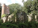 More images
|
| Badcocks Farmhouse | Copford | Farmhouse | Late 15th century | 23 June 1952 | TL9004321086 51°51′22″N 0°45′29″E / 51.855997°N 0.758187°E |
1239073 | Upload Photo |
| Easthorpe Hall | Copford | House | 17th century | 23 June 1952 | TL9116621513 51°51′34″N 0°46′29″E / 51.859449°N 0.774709°E |
1273949 | Upload Photo |
| St Mary's Grange | Copford | House | Late 15th century | 23 June 1952 | TL9161521602 51°51′36″N 0°46′53″E / 51.860094°N 0.78127°E |
1239072 | Upload Photo |
| Brook House | Dedham | Jettied house | 16th century | 23 June 1952 | TM0583333190 51°57′33″N 0°59′40″E / 51.959079°N 0.994371°E |
1239284 | Upload Photo |
| Dale Brook | Dedham | House | c.1780 | 23 June 1952 | TM0582133190 51°57′33″N 0°59′39″E / 51.959083°N 0.994197°E |
1239313 | Upload Photo |
| Essex Rose Cafe | Dedham | Jettied house | 15th/16th century | 23 June 1952 | TM0575433196 51°57′33″N 0°59′36″E / 51.959162°N 0.993227°E |
1239326 |  More images
|
| Gould House | Dedham | House | 18th century | 23 June 1952 | TM0581033187 51°57′33″N 0°59′39″E / 51.959061°N 0.994035°E |
1273803 |  More images
|
| Great House | High Street, Dedham | House | 1937–38 | 6 July 1981 | TM0557733100 51°57′30″N 0°59′26″E / 51.958366°N 0.990597°E |
1239335 |  More images
|
| House and shop occupied by F R Spearing next to Shermans | Dedham | House | 18th century | 23 June 1952 | TM0571333173 51°57′32″N 0°59′33″E / 51.958971°N 0.992617°E |
1273804 | Upload Photo |
| Ivy House | Dedham | House | 1767 | 23 June 1952 | TM0573733181 51°57′33″N 0°59′35″E / 51.959034°N 0.992971°E |
1239286 |  More images
|
| Knights Manor | Dedham | Manor house | 16th century | 23 June 1952 | TM0613332234 51°57′01″N 0°59′53″E / 51.950385°N 0.998158°E |
1273808 | Upload Photo |
| Le Talbooth | Gun Hill, Dedham | Jettied house | 16th century | 22 November 1967 | TM0421933464 51°57′44″N 0°58′16″E / 51.962134°N 0.971077°E |
1239265 |  More images
|
| Loom House & Marlborough Head Inn | Dedham | Houses | Later | 23 June 1952 | TM0578633184 51°57′33″N 0°59′37″E / 51.959043°N 0.993685°E |
1239285 |  More images
|
| Rye Farmhouse | Dedham | Farmhouse | c.1400 | 27 January 1982 | TM0473031516 51°56′40″N 0°58′38″E / 51.944456°N 0.977345°E |
1239440 | Upload Photo |
| Shakespeare House | Dedham | House | Later | 23 June 1952 | TM0565733151 51°57′32″N 0°59′30″E / 51.958794°N 0.99179°E |
1239331 |  More images
|
| Sheldrakes | Dedham | House | 18th century | 7 April 1965 | TM0566333132 51°57′31″N 0°59′31″E / 51.958621°N 0.991866°E |
1239317 | Upload Photo |
| The Sun Public House | Dedham | Jettied house | 14th century | 23 June 1952 | TM0568233174 51°57′32″N 0°59′32″E / 51.958991°N 0.992167°E |
1273783 |  More images
|
| Vale Bakery | Dedham | Bakery | Late medieval | 7 April 1965 | TM0562133123 51°57′31″N 0°59′28″E / 51.958556°N 0.99125°E |
1239332 |  More images
|
| 1 High Street | Dedham | Timber-framed house | 18th century | 23 June 1952 | TM0584433191 51°57′33″N 0°59′40″E / 51.959084°N 0.994532°E |
1239312 | Upload Photo |
| Barnards Farmhouse | Fordham | Farmhouse | 14th century | 27 January 1982 | TL9198627322 51°54′41″N 0°47′23″E / 51.911333°N 0.789832°E |
1239874 | Upload Photo |
| Wash Farmhouse | Fordham | Farmhouse | 13th century | 27 January 1982 | TL9190627384 51°54′43″N 0°47′19″E / 51.911918°N 0.788705°E |
1239836 | Upload Photo |
| Church of St Nicholas | Little Wigborough, Great and Little Wigborough | Church | 15th century | 7 April 1965 | TL9809114540 51°47′40″N 0°52′16″E / 51.79442°N 0.871153°E |
1223007 |  More images
|
| Church of St Stephen | Great Wigborough, Great and Little Wigborough | Church | 14th century | 7 April 1965 | TL9680715640 51°48′17″N 0°51′11″E / 51.804751°N 0.853182°E |
1223003 | 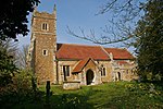 More images
|
| Chapel Cottage | Great Horkesley | House | 15th century | 23 June 1952 | TL9772130967 51°56′31″N 0°52′31″E / 51.942059°N 0.875192°E |
1222607 |  More images
|
| Cockerills | Great Horkesley | Cross-wing house | 14th century | 7 April 1965 | TL9772831610 51°56′52″N 0°52′32″E / 51.94783°N 0.875663°E |
1222741 | Upload Photo |
| Gulls Farmhouse | Great Tey | Farmhouse | 15th century | 27 January 1982 | TL8715024732 51°53′23″N 0°43′06″E / 51.889718°N 0.718204°E |
1267431 | Upload Photo |
| The Hall | Langham | House | c.1740 | 27 January 1982 | TM0322233656 51°57′51″N 0°57′24″E / 51.964223°N 0.9567°E |
1223465 | Upload Photo |
| Valley House | Langham | House | 17th century | 23 June 1952 | TM0199634291 51°58′13″N 0°56′21″E / 51.970371°N 0.939253°E |
1223746 | Upload Photo |
| Layer Breton Hall | Layer Breton | House | Mid-18th century | 27 January 1982 | TL9486517131 51°49′08″N 0°49′33″E / 51.81882°N 0.82589°E |
1267120 | Upload Photo |
| Duke's Farmhouse | Layer Marney | Farmhouse | 16th century | 23 June 1952 | TL9305918267 51°49′47″N 0°48′01″E / 51.829648°N 0.800353°E |
1267081 |  More images
|
| Wick Farmhouse | Layer Marney | Cross-wing house | 15th century | 27 January 1982 | TL9308517484 51°49′21″N 0°48′01″E / 51.822607°N 0.800294°E |
1223989 | Upload Photo |
| Blind Knights | Layer-de-la-Haye | House | Early 15th century | 18 May 1979 | TL9763219069 51°50′07″N 0°52′02″E / 51.835252°N 0.867088°E |
1267086 | Upload Photo |
| Malting Green House | Layer-de-la-Haye | House | Early 18th century | 27 January 1982 | TL9756119950 51°50′35″N 0°52′00″E / 51.843188°N 0.866561°E |
1223909 |  More images
|
| Holt's Farmhouse | Little Horkesley | Farmhouse | c. 1750 (frontage) | 27 January 1982 | TL9479131125 51°56′40″N 0°49′58″E / 51.944511°N 0.83271°E |
1223990 | Upload Photo |
| King's Farmhouse | Little Horkesley | Farmhouse | 15th century or earlier | 7 April 1965 | TL9629631698 51°56′57″N 0°51′18″E / 51.949127°N 0.854905°E |
1224018 | 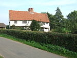 More images
|
| Little Horkesley Hall | Little Horkesley | House | 18th century | 27 January 1982 | TL9599931868 51°57′03″N 0°51′02″E / 51.950758°N 0.850686°E |
1267036 | Upload Photo |
| Old Josselyns | Little Horkesley | House | Modern | 23 June 1952 | TL9639232612 51°57′26″N 0°51′25″E / 51.957301°N 0.856822°E |
1266816 |  More images
|
| The Priory | Little Horkesley | Farmhouse | 17th century | 27 January 1982 | TL9607431991 51°57′07″N 0°51′07″E / 51.951837°N 0.851846°E |
1224435 | Upload Photo |
| Westwood Park | Little Horkesley | Country house | 17th century | 27 January 1982 | TL9619529988 51°56′02″N 0°51′09″E / 51.933808°N 0.852462°E |
1267009 | Upload Photo |
| Barn south of Marks Tey Hall | Marks Tey | Barn | c.1400 | 27 January 1982 | TL9168123306 51°52′31″N 0°46′59″E / 51.875374°N 0.783173°E |
1224577 | Upload Photo |
| Barn to south-west of Little Tey House | Marks Tey | Aisled barn | 16th century | 27 January 1982 | TL8928924405 51°53′10″N 0°44′57″E / 51.88606°N 0.749069°E |
1266779 | Upload Photo |
| Church of All Saints | Messing, Messing-cum-Inworth | Church | 13th century | 7 April 1965 | TL8968518930 51°50′12″N 0°45′07″E / 51.836757°N 0.751813°E |
1224665 | 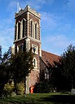 More images
|
| Messing Park | Messing Park, Messing-cum-Inworth | House | Early 18th century | 7 April 1965 | TL8939318026 51°49′43″N 0°44′50″E / 51.828737°N 0.747085°E |
1224649 | Upload Photo |
| Games Farmhouse | Peldon | Farmhouse | Early 15th century | 27 January 1982 | TL9879516278 51°48′35″N 0°52′56″E / 51.809777°N 0.882344°E |
1266661 | Upload Photo |
| Church of St Mary | Salcott cum Virley | Church | 14th century | 7 April 1965 | TL9519713590 51°47′13″N 0°49′43″E / 51.786906°N 0.828708°E |
1224767 |  More images
|
| Beaconhead Farmhouse | Stanway | Farmhouse | 14th century | 27 January 1982 | TL9530024803 51°53′15″N 0°50′11″E / 51.887562°N 0.836524°E |
1224842 | More images
|
| Catchbells | Stanway | House | c.1500 | 27 January 1982 | TL9411224407 51°53′04″N 0°49′09″E / 51.884421°N 0.819061°E |
1224841 |  More images
|
| Church of All Saints | Stanway | Church | Late 13th century | 16 June 1999 | TL9532022056 51°51′46″N 0°50′07″E / 51.862887°N 0.835261°E |
1266610 | 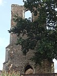 More images
|
| Olivers | Stanway | House | 17th century | 7 April 1965 | TL9670721437 51°51′25″N 0°51′18″E / 51.856842°N 0.855026°E |
1224900 | Upload Photo |
| Parish Church of St Albright | Stanway | Parish church | 12th century | 7 April 1965 | TL9403924318 51°53′01″N 0°49′05″E / 51.883647°N 0.817952°E |
1224899 |  More images
|
| Church of All Saints | Wakes Colne | Parish church | Norman | 7 April 1965 | TL8896628605 51°55′26″N 0°44′48″E / 51.923887°N 0.746683°E |
1225059 |  More images
|
| Normans Farmhouse | Wakes Colne | Farmhouse | c.1300 | 27 January 1982 | TL8865530347 51°56′23″N 0°44′35″E / 51.939637°N 0.74312°E |
1225019 | Upload Photo |
| Old House | Wakes Colne | House | 17th century | 27 January 1982 | TL8975029170 51°55′43″N 0°45′30″E / 51.928695°N 0.758381°E |
1225029 |  More images
|
| Watch House | Wakes Colne | Open hall house | c.1520 | 27 January 1982 | TL8957128540 51°55′23″N 0°45′20″E / 51.923098°N 0.755435°E |
1224980 |  More images
|
| Cooks Hall | West Bergholt | House | 16th century | 27 January 1982 | TL9500527364 51°54′38″N 0°50′01″E / 51.910663°N 0.83369°E |
1225091 |  More images
|
| High Trees Farmhouse | West Bergholt | Farmhouse | Early 15th century | 23 June 1952 | TL9590728276 51°55′07″N 0°50′50″E / 51.918536°N 0.847305°E |
1225133 | Upload Photo |
| Horsepits Farmhouse | West Bergholt | Farmhouse | 16th century or earlier | 23 June 1952 | TL9543927112 51°54′30″N 0°50′23″E / 51.908248°N 0.839849°E |
1266529 | Upload Photo |
| The Hall | West Bergholt | House | 18th century | 7 April 1965 | TL9523728060 51°55′01″N 0°50′15″E / 51.916831°N 0.837453°E |
1266531 |  More images
|
| Yew Tree House, gate and gatepiers | West Mersea | House | Early 18th century | 11 October 1949 | TM0084012476 51°46′30″N 0°54′35″E / 51.774907°N 0.909768°E |
1266512 | Upload Photo |
| The Church of St Mary | Wivenhoe | Parish church | Mid-14th century | 3 May 1949 | TM0389921524 51°51′18″N 0°57′34″E / 51.855044°N 0.959366°E |
1225318 |  More images
|
| Jenkins Farmhouse | Wormingford | Farmhouse | 16th century | 23 June 1952 | TL9308130723 51°56′29″N 0°48′27″E / 51.941496°N 0.807637°E |
1225427 |  More images
|
| Rochfords | Wormingford | House | 16th century | 23 June 1952 | TL9329730373 51°56′18″N 0°48′38″E / 51.938278°N 0.810579°E |
1225428 | Upload Photo |
| Church of St James the Great | Colchester | Church | 13th to 15th century | 24 February 1950 | TM0016525238 51°53′23″N 0°54′27″E / 51.889744°N 0.907373°E |
1307051 |  More images
|
| Church of St Michael | Berechurch | Bell tower | 14th century | 24 February 1950 | TL9928521888 51°51′36″N 0°53′34″E / 51.859978°N 0.89267°E |
1123672 |  More images
|
| Church of St Peter | Colchester | Church | Early 15th century | 24 February 1950 | TL9943525240 51°53′24″N 0°53′48″E / 51.890023°N 0.896781°E |
1123570 |  More images
|
| Colchester Club | Colchester | House | Mid-18th century | 24 February 1950 | TL9992825170 51°53′21″N 0°54′14″E / 51.889218°N 0.903894°E |
1337710 |  More images
|
| Column and street light, left of entrance to Town Hall | Colchester | Column | c.1898 | 8 September 1993 | TL9958525213 51°53′23″N 0°53′56″E / 51.889727°N 0.898942°E |
1230447 |  More images
|
| Column and street light, right of entrance to Town Hall | Colchester | Column | c.1898 | 8 September 1993 | TL9959425215 51°53′23″N 0°53′57″E / 51.889742°N 0.899074°E |
1230446 |  More images
|
| Employment Exchange | Colchester | House | Early 18th century | 2 December 1971 | TL9964825319 51°53′26″N 0°54′00″E / 51.890657°N 0.899917°E |
1337704 |  More images
|
| Essex and Suffolk Fire Office | Colchester | Corn exchange | 1820 | 24 February 1950 | TL9943725211 51°53′23″N 0°53′48″E / 51.889762°N 0.896793°E |
1306789 |  More images
|
| Former Church of St Leonard at the Hythe | Hythe | Church | 12th century | 24 February 1950 | TM0128024719 51°53′05″N 0°55′24″E / 51.884683°N 0.923251°E |
1123578 |  More images
|
| Former Church of St Martin | Colchester | Church | Early 12th century (origin) | 2 December 1971 | TL9961025347 51°53′27″N 0°53′58″E / 51.890922°N 0.899382°E |
1337393 |  More images
|
| Garrison Church | Colchester Garrison | Military chapel | 1856 | 2 December 1971 | TM0039524387 51°52′55″N 0°54′37″E / 51.88202°N 0.910217°E |
1123564 |  More images
|
| Grey Friars | Colchester | House | 18th century | 24 February 1950 | TM0005725268 51°53′24″N 0°54′21″E / 51.890052°N 0.905823°E |
1123611 |  More images
|
| Headgate Court, Colchester | Colchester | Courtyard | 16th–17th century | 24 February 1950 | TL9936025041 51°53′18″N 0°53′44″E / 51.888263°N 0.895577°E |
1337707 |  More images
|
| Municipal Water Tower ("Jumbo") | Colchester | Water tower | 1882 | 2 December 1971 | TL9932125182 51°53′22″N 0°53′42″E / 51.889543°N 0.895093°E |
1123669 |  More images
|
| Rear wing of the Old Siege House | Colchester | House | Early 19th century | 2 December 1971 | TM0072825326 51°53′25″N 0°54′56″E / 51.890332°N 0.915594°E |
1123628 |  More images
|
| Summerhouse at Number 74 (the Minories) | Colchester | Summerhouse | Mid-18th century | 19 February 1959 | TM0001325176 51°53′21″N 0°54′18″E / 51.889242°N 0.905131°E |
1123608 |  More images
|
| The George Hotel | Colchester | House | 17th century | 24 February 1950 | TL9973525258 51°53′24″N 0°54′04″E / 51.890078°N 0.901145°E |
1123614 | 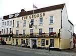 More images
|
| The Marquis of Granby Inn | Colchester | Inn | Early 16th century | 24 February 1950 | TL9941125469 51°53′32″N 0°53′48″E / 51.892088°N 0.896565°E |
1123534 |  More images
|
| The Minories | Colchester | House | Later 18th century | 24 February 1950 | TM0000925230 51°53′23″N 0°54′18″E / 51.889728°N 0.905105°E |
1123607 |  More images
|
| The Scheregate | Colchester | Timber-framed house | 17th century | 24 February 1950 | TL9962125012 51°53′16″N 0°53′58″E / 51.88791°N 0.899348°E |
1337769 |  More images
|
| The Siege House | Colchester | House | Early 16th century | 19 February 1959 | TM0073825318 51°53′25″N 0°54′57″E / 51.890256°N 0.915735°E |
1123627 | 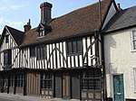 More images
|
| Tymperleys | Colchester | House | 15th–16th century | 24 February 1950 | TL9957325084 51°53′19″N 0°53′55″E / 51.888573°N 0.898693°E |
1169553 |  More images
|
| Wivenhoe House | Wivenhoe Park | Country house | 1759 | 1 June 1973 | TM0327524120 51°52′43″N 0°57′07″E / 51.878581°N 0.951845°E |
1225229 |  More images
|
| 3–5 West Stockwell Street | Colchester | Timber-framed house | Late 15th century | 19 February 1959 | TL9960225278 51°53′25″N 0°53′57″E / 51.890305°N 0.899226°E |
1110922 |  More images
|
| 29–31 West Stockwell Street | Colchester | Timber-framed house | c.1600 | 24 February 1950 | TL9954225466 51°53′31″N 0°53′54″E / 51.892014°N 0.898464°E |
1110929 |  |
| 54 Head Street | Colchester | House | 1774 | 24 February 1950 | TL9943225035 51°53′17″N 0°53′48″E / 51.888184°N 0.896619°E |
1123596 |  |
| 11A and 11B High Street | Colchester | House | 17th century | 24 February 1950 | TL9948925169 51°53′22″N 0°53′51″E / 51.889366°N 0.897523°E |
1123597 |  |
| 71 Culver Street | Colchester | House | 18th century | 24 February 1950 | TL9994225169 51°53′21″N 0°54′15″E / 51.889204°N 0.904097°E |
1123644 |  More images
|
| 20 and 22 Crouch Street | Colchester | House | Mid-18th century | 24 February 1950 | TL9927524953 51°53′15″N 0°53′39″E / 51.887503°N 0.894293°E |
1123643 |  |
| 9 and 10 East Hill | Colchester | Town house | Early Georgian | 24 February 1950 | TM0027325224 51°53′22″N 0°54′32″E / 51.889579°N 0.908932°E |
1123650 |  More images
|
| 60 North Hill | Colchester | House | 17th century | 24 February 1950 | TL9938425270 51°53′25″N 0°53′46″E / 51.890311°N 0.896058°E |
1169334 |  |
| 6 Trinity Street | Colchester | House | 18th century | 1 August 1968 | TL9959525105 51°53′20″N 0°53′56″E / 51.888754°N 0.899024°E |
1337771 |  More images
|
| 13–15 North Hill | Colchester | Shop | Later 19th century | 24 February 1950 | TL9942025377 51°53′29″N 0°53′48″E / 51.891259°N 0.896642°E |
1337776 |  More images
|
| 58-62 Head Street, 17 Sir Isaac's Walk | Colchester | Cellar | Late 17th century (medieval cellar) | 24 February 1950 | TL9943525012 51°53′17″N 0°53′48″E / 51.887976°N 0.896649°E |
1337728 | 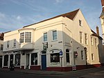 More images
|
| Colchester War Memorial | Colchester | War memorial | 1923 | 7 July 2006 | TL9992525247 51°53′24″N 0°54′14″E / 51.889911°N 0.90389543°E |
1391704 |  More images
|
See also edit
- Grade I listed buildings in Essex
- Grade II* listed buildings in Essex
- Grade II* listed buildings in Basildon (district)
- Grade II* listed buildings in Braintree (district)
- Grade II* listed buildings in Brentwood (borough)
- Grade II* listed buildings in Castle Point
- Grade II* listed buildings in Chelmsford (borough)
- Grade II* listed buildings in Epping Forest (district)
- Grade II* listed buildings in Harlow
- Grade II* listed buildings in Maldon (district)
- Grade II* listed buildings in Rochford (district)
- Grade II* listed buildings in Southend-on-Sea
- Grade II* listed buildings in Tendring
- Grade II* listed buildings in Thurrock
- Grade II* listed buildings in Uttlesford
- Churches in Colchester
Notes edit
- ^ The date given is the date used by Historic England as significant for the initial building or that of an important part in the structure's description.
- ^ Sometimes known as OSGB36, the grid reference is based on the British national grid reference system used by the Ordnance Survey.
- ^ The "List Entry Number" is a unique number assigned to each listed building and scheduled monument by Historic England.